
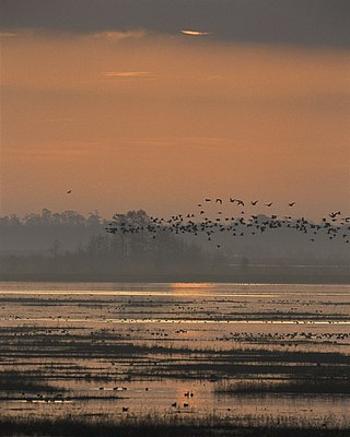
The Shiawassee National Wildlife Refuge is a 9,870.35 acres (39.9439 km2) National Wildlife Refuge in Saginaw County managed by the United States Fish and Wildlife Service. It is located in the central portion of the lower peninsula of the U.S. state of Michigan, approximately 25 miles (40 km) south of the Saginaw Bay in Lake Huron and five miles (8 km) south of the city of Saginaw in the county's Spaulding and James townships. It was established in 1953 to provide habitat for migratory waterfowl.

The Arthur R. Marshall Loxahatchee National Wildlife Refuge is a 145,188-acre (587.55 km2) wildlife sanctuary is located west of Boynton Beach, in Palm Beach County, Florida. It is also known as Water Conservation Area 1 (WCA-1). It includes the most northern remnant of the historic Everglades wetland ecosystem.

Waterfowl hunting is the practice of hunting aquatic birds such as ducks, geese and other waterfowls or shorebirds for sport and meat. Waterfowl are hunted in crop fields where they feed, or in areas with bodies of water such as rivers, lakes, ponds, wetlands, sloughs, or coasts. There are around 3 million waterfowl hunters in the United States alone.

The Erie National Wildlife Refuge is an 8,777-acre (3,552 ha) National Wildlife Refuge located in Crawford County, Pennsylvania. Named after the Erie tribe, it was established to provide waterfowl and other migratory birds with nesting, feeding, brooding, and resting habitat.
The Yazoo National Wildlife Refuge is a 12,941 acre (52.4 km2) National Wildlife Refuge located in Washington County, Mississippi. Named after the Yazoo tribe, it was established to provide waterfowl and other migratory birds in the Mississippi Flyway with nesting, feeding, brooding, and resting habitat.

The National Wildlife Refuge System in the United States has a long and distinguished history.

The Atlantic Flyway is a major north-south flyway for migratory birds in North America. The route generally starts in Greenland, then follows the Atlantic coast of Canada, then south down the Atlantic Coast of the United States to the tropical areas of South America and the Caribbean. Every year, migratory birds travel up and down this route following food sources, heading to breeding grounds, or traveling to overwintering sites.
Audubon Wetland Management District is located in the U.S. state of North Dakota and consists of 123 Waterfowl Production Areas (WPAs), 8 National Wildlife Refuges (NWRs), and numerous wetland and grassland easements and over 100 separate wetland areas set aside to preserve habitat for bird, plant and mammal species. These lands contain valuable wetland and grassland habitat for waterfowl and other migratory birds, and many other species of wildlife. Scattered throughout west central and southwestern North Dakota in McLean, Ward, and Sheridan Counties, the district is managed by the U.S. Fish and Wildlife Service and from Audubon National Wildlife Refuge. Hundreds of lakes and marshlands in this region provide critical habitat for migratory and nesting bird species.
The Atchafalaya National Wildlife Refuge is located about 30 miles (48 km) west of Baton Rouge, Louisiana, and one mile (1.6 km) east of Krotz Springs, Louisiana, lies just east of the Atchafalaya River. In 1988 under the administration of Governor Foster the "Atchafalaya Basin Master Plan" was implemented that combined the 11,780-acre (4,770 ha) Sherburne Wildlife Management Area (WMA), the 15,220-acre (6,160 ha) Atchafalaya National Wildlife Refuge, and the 17,000-acre (6,900 ha) U.S. Army Corps of Engineers' Bayou Des Ourses into the Sherburne Complex Wildlife Management Area.

Black Bayou Lake National Wildlife Refuge is one of five refuges managed in the North Louisiana Refuge Complex and one of 545 refuges in the National Wildlife Refuge System. It was established in 1997 through a unique partnership with the city of Monroe, Louisiana. The U.S. Fish and Wildlife Service has a free 99-year lease to manage the city-owned lake.
Lacassine National Wildlife Refuge is located in Cameron and Evangeline Parishes in southwestern Louisiana, was established in 1937 by Executive Order No. 7780 as "a refuge and breeding ground for migratory birds and other wildlife." The refuge is nearly 35,000 acres (140 km2) in size, including 653 acres (2.64 km2) leased from the Cameron Parish School Board. The Evangeline Parish unit is called Duralde Prairie and is currently being developed. It is located south of the city of Eunice.
Lake Ophelia National Wildlife Refuge was established in 1988 to protect the Mississippi/Red River floodplain ecosystem. The refuge is located in Avoyelles Parish, Louisiana, east central Louisiana. The refuge is named for its most prominent water body, the 350-acre (1.4 km2) Lake Ophelia that was at one time a channel of the nearby Red River of the South.
The North American Wetlands Conservation Act signed into law by President George H. W. Bush on December 13, 1989 authorizes a wetlands habitat program, administered by the United States Fish and Wildlife Service, which provides grants to protect and manage wetland habitats for migratory birds and other wetland wildlife in the United States, Mexico, and Canada. A nine-member council meets periodically to decide which projects to fund.
Pass a Loutre Wildlife Management Area (WMA) is a 115,000-acre (47,000 ha) protected wetland in Plaquemines Parish, Louisiana, United States. The WMA is located due south and bordering the 48,000 acre Delta National Wildlife Refuge, accessible only by air or boat, contains the Pass A L'Outre Lighthouse, and Port Eads is within the boundary.

The Summer Lake Wildlife Area is a 29.6-square-mile (77 km2) wildlife refuge located on the northwestern edge of the Great Basin drainage in south-central Oregon. It is administered by the Oregon Department of Fish and Wildlife. The refuge is an important stop for waterfowl traveling along the Pacific Flyway during their spring and fall migrations. The Summer Lake Wildlife Area also provides habitat for shorebirds and other bird species as well as wide variety of mammals and several fish species. The Ana River supplies the water for the refuge wetlands.
The Louisiana Department of Wildlife and Fisheries (LDWF) is a state agency of Louisiana that maintains state wildlife and fishery areas. The agency is headquartered in the capital city of Baton Rouge.
Over the past 200 years, the United States has lost more than 50% of its wetlands. And even with the current focus on wetland conservation, the US is losing about 60,000 acres (240 km2) of wetlands per year. However, from 1998 to 2004 the United States managed a net gain of 191,750 acres (776.0 km2) of wetlands . The past several decades have seen an increasing number of laws and regulations regarding wetlands, their surroundings, and their inhabitants, creating protections through several different outlets. Some of the most important have been and are the Migratory Bird Act, Swampbuster, and the Clean Water Act.

The fauna of Louisiana is characterized by the region's low swamplands, bayous, creeks, woodlands, coastal marshlands and beaches, and barrier islands covering an estimated 20,000 square miles, corresponding to 40 percent of Louisiana's total land area. Southern Louisiana contains up to fifty percent of the wetlands found in the Continental United States, made up of countless bayous and creeks.
White Lake Wetlands Conservation Area (WLWCA), officially the White Lake Property, is a 71,905-acre tract of protected area located 7.4 miles (11.9 km) south of Gueydan at the south end of Louisiana Highway 91 in Vermilion Parish, Louisiana.
Maurepas Swamp Wildlife Management Area is a 112,615-acre (45,574 ha) tract of protected area located in parts of Ascension, Livingston, St. John the Baptist, St. James and Tangipahoa Parishes, Louisiana, encircling three sides of Lake Maurepas.

