Carrigaline is a town and civil parish in County Cork, Ireland, situated on the River Owenabue. It is about 14 kilometres (8.7 mi) south of Cork city on the R611 regional road, which passes through the town, and just off the N28 national primary route to Ringaskiddy. Carrigaline grew rapidly in the late 20th century, from a village of a few hundred people into a thriving commuter town, although many locals still refer to it as "the village". The town is one of the key gateways to west Cork, especially for those who arrive by ferry from France. Carrigaline is within the Cork South-Central Dáil constituency.

Carrigallen is a small village in County Leitrim, Ireland. It is located on the R201 and R203 roads in the east of the county. As of 2016, the village had a population of 387.
Ballincollig is a suburban town within the administrative area of Cork city in Ireland. It is located on the western side of Cork city, beside the River Lee on the R608 regional road. In 2016 it was the largest town in County Cork, at which time the Ballincollig Electoral Division had a population of 18,621 people. The nearest towns include Ballinora, Carrigrohane, Kilnaglory, Ovens, Killumney, Inniscarra, Blarney, and Tower. It is located beyond the green belt from the suburbs of Bishopstown and Wilton. Ballincollig is within the Cork North-West Dáil constituency.
Kildorrery is a village in north County Cork, Ireland. It lies at the crossroads of the N73 road from Mallow to Mitchelstown and the R512 from Kilmallock to Fermoy.

Douglas is a village and suburb contained within Cork city, Ireland and the name given to the Roman Catholic, Church of Ireland and Civil parish in which it is contained. Originally a village, the growth of both the village and the city has meant Douglas has become incorporated into the city over time. The 2017 Mackinnon Report proposed that Douglas and surrounding residential areas be moved to within an extended Cork city boundary, ending the division of Douglas between the city and county administrative areas. This was approved by the Cabinet on 6 June 2018, with Douglas and surrounding areas Rochestown, Grange and Frankfield to move into the city council area following the 2019 local elections. This change occurred on 31 May 2019, ending the divide between the separated halves of Douglas.

Clondulane is a village in north County Cork, Ireland, 3.5m east of Fermoy, just off the Main Fermoy-Dungarvan Road. Originally built as a camp for the workers of a Cork Milling Company grain mill, it now has a population of over 400. Clondulane is part of the Cork East Dáil constituency.

Durrus is a village and civil parish in West Cork in Ireland. It is situated six miles (9.7 km) from Bantry in County Cork, at the head of the Sheep's Head and the Mizen Head peninsulas.
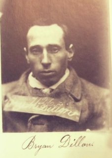
Brian Dillons is one of the oldest GAA clubs in the city of Cork. It is named after the Irish Fenian, Brian Dillon and its original clubhouse was less than 100 metres from Dillon's home. The club is now based at the Tank Field in Montenotte and has playing pitches and dressing rooms at Lisnahorna, White's Cross.

Killavullen is a village on the river Blackwater, in County Cork, Ireland. The village is located just south of the N72 road, between Mallow and Castletownroche. It is 10 km (6.2 mi) east of Mallow and 32 km (20 mi) north of Cork city. The census of 2002 put the population at 224. The parish of Killavullen & Annakissa contains close to 1500 people.

Carriganima or Carriganimmy is a village in the Barony of Muskerry, County Cork, Ireland, situated approximately 11 km northwest of Macroom and 10 km south of Millstreet. The village lies in a valley between the Boggeragh and Derrynasaggart mountain ranges.

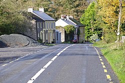
Carrigadrohid is a townland and village in the parish of Aghinagh, County Cork, Ireland. It is situated on the north bank of the River Lee, with the nearby village of Canovee to the south. Carrigadrohid is part of the Dáil constituency of Cork North-West.

Nohoval is a village located in County Cork, Ireland. St. Patrick's and Nohoval Parish Church are located in the village. It is approximately 26 kilometres (16 mi) south of the city of Cork, approximately 16 km (9.9 mi) south of Carrigaline and 10 km (6.2 mi) east of Kinsale.
Kildorrery GAA is a Gaelic Athletic Association based in the parish of Kildorrery, Cork, Ireland. The club fields teams in competitions organized by the Cork GAA county board and the Avondhu GAA divisional board. The club fields teams in both hurling and Gaelic football.

Carrigrohane is a village and civil parish situated on the south bank of the River Lee to the west of the city of Cork in Ireland. It is connected by the Carrigrohane Straight, 4 miles (6.4 km) west of Cork and is also in the northeastern part of Ballincollig. It contains St Peter's Church of the Resurrection. In 1837, it had a population of 1921 inhabitants. The civil parish is almost evenly split between the baronies of Muskerry East to the west and the Barony of Cork to the east.
Fermoy is a barony in County Cork in Ireland. It is bordered by the baronies of Orrery and Kilmore to the north-west; Duhallow to the west; Barretts to the south-west; Barrymore to the south; Condons and Clangibbon to the east; and Coshlea, County Limerick to the north. It is bounded to the south by the Nagle Mountains and the valley of the Munster Blackwater. The Ballyhoura Mountains mark the northern boundary. A tributary of the Blackwater, the Awbeg has two branches in its upper stretches; one branch forms the northern boundary while the other near Buttevant, forms the western limit. To the east, lies another Blackwater tributary, the Funcheon. Anomalously, the namesake town of Fermoy is actually in the barony of Condons and Clangibbon. The town with the greatest population in the barony is Mallow.

Carrignamuck is a townland within the civil parish of Magourney and catholic parish of Aghabullogue, County Cork, Ireland. It is 363.76 acres in size, situate north-east of Coachford village, and north-west of Dripsey village.
The 2016 Cork Intermediate Hurling Championship was the 107th staging of the Cork Intermediate Hurling Championship since its establishment by the Cork County Board in 1909. The draw for the opening rounds took place on 13 December 2015. The championship began on 21 May 2016 and ended on 30 October 2016.
The 2015 Cork Intermediate Hurling Championship was the 106th staging of the Cork Intermediate Hurling Championship since its establishment by the Cork County Board in 1909. The draw for the opening round fixture took place on 14 December 2014. The championship began on 16 May 2015 and ended on 24 October 2015.
The 2014 Cork Intermediate Hurling Championship was the 105th staging of the Cork Intermediate Hurling Championship since its establishment by the Cork County Board in 1909. The draw for the opening rounds took place on 14 December 2014. The championship began on 31 May 2014 and ended on 26 October 2014.