Kleanza Creek Provincial Park is a provincial park in British Columbia, Canada. Kleanza Creek is a tributary of the Skeena River. The park occupies over an area of 269 hectares.

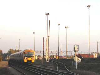
Hoo Junction is a rail yard on the North Kent Line, near the village of Higham, Kent and Shorne Marshes, operated by DB Schenker. It is between Gravesend and Higham stations, at the junction with the freight-only single-track Hoo branch to the Hoo Peninsula.

Berlin Sundgauer Straße is a railway station in the Zehlendorf locality of Berlin, Germany, served by the Berlin S-Bahn and a local bus line.

Verftet is a neighbourhood of Bergen, Norway. It is located on the Nordnes peninsula. It is the location of Georgernes Verft.

Une Station is a railway station on the Sanyō Main Line in Akō, Hyōgo Prefecture, Japan, operated by West Japan Railway Company.
Kossaki-Borowe is a village in the administrative district of Gmina Kołaki Kościelne, within Zambrów County, Podlaskie Voivodeship, in north-eastern Poland.
Wysokie Pierwsze is a village in the administrative district of Gmina Skierbieszów, within Zamość County, Lublin Voivodeship, in eastern Poland.

Ossy is a village in the administrative district of Gmina Ożarowice, within Tarnowskie Góry County, Silesian Voivodeship, in southern Poland. It lies approximately 6 kilometres (4 mi) south-west of Ożarowice, 10 km (6 mi) east of Tarnowskie Góry, and 21 km (13 mi) north of the regional capital Katowice.

The Parc du 26e Centenaire is a public park located in the 8th arrondissement of Marseille, France. It is listed by the French Ministry of Culture as one of the Notable Gardens of France.
Bannach is a municipality in the state of Pará in the Northern region of Brazil.

Córrego Novo is a municipality in the state of Minas Gerais in the Southeast region of Brazil.

Clevelândia is a municipality in the state of Paraná in the Southern Region of Brazil. Its name is an homage to American president Grover Cleveland.
Levosoje is a village in the municipality of Bujanovac, Serbia. According to the 2002 census, the town has a population of 840 people.
Creswell High School is a public high school located in Creswell, North Carolina. It is one of two high schools, along with Plymouth High School, in Washington County Schools. Creswell High School serves grades 6 - 12. Creswell High School's enrollment as of 2010 is 161 students. The student body is 52% Black; 39% White; 5% Hispanic; and 4% Unknown. All Creswell students receive a free or reduced lunch.

Ca' Farsetti is a palace in Venice, Italy. It is located in the sestiere (district) of San Marco, and faces the Grand Canal, not far from the Ponte di Rialto.
The Autovía V-31 is an autovía in Valencia, Spain. It is 13 km long and runs from the junction of the Autopista AP-7 and the Autovía A-7 near the small town of Silla to the Autovía V-30 on the southern outskirts of the city centre. Built as an upgrade of the N-332 road, it is frequently used by drivers travelling between Valencia and Alicante.
Chah Varz District is a Districts (bakhsh) in the lamerd County, Fars Province, Iran. At the 2006 census, its population was 7,985, in 1,565 families. The district has 2 rural districts:

Ledwyche Brook is a minor river in south Shropshire, England. It is sometimes referred to as the River Ledwyche and spelled variously, including "Ledwich" or "Ledwych". The brook is a tributary of the River Teme.
Stareyshino is a village in Kirkovo Municipality, Kardzhali Province, southern Bulgaria.

National Nature Park Upper Pobozhia is one of National Parks in Ukraine, located in Khmelnitsky Oblast, in western part of the country. It was established in 2013 and covers an area of 108,000 hectares (1,080 km2). The Park has its headquarters in the town of Khmelnitsky.


