Rolleston Junction–Mansfield line

Last updated

Contents

Rolleston Junction to Mansfield line
BSicon CONT2.svg
BSicon STRc3.svg
BSicon STRc1.svg
BSicon ABZ4+2xf.svg
BSicon STRc3.svg
BSicon STRc1.svg
BSicon exABZg+l.svg
BSicon ABZ2+4xr.svg
BSicon STRc3.svg
BSicon exSTR.svg
BSicon STRc1.svg
BSicon HST2+4.svg
BSicon STRc3.svg
Mansfield
BSicon exSTR.svg
BSicon STRc1.svg
BSicon CONT4.svg
BSicon exCONTgq.svg
BSicon exKRZo.svg
BSicon exCONTfq.svg
BSicon exABZgl.svg
BSicon exKBSTeq.svg
BSicon exABZgl.svg
BSicon exCONTfq.svg
to Rufford, Clipstone collieries
BSicon exHST.svg
Blidworth and Rainworth
BSicon exdKBSTaq.svg
BSicon exABZq+l.svg
BSicon exABZgr.svg
Blidworth Colliery
BSicon exSTRl.svg
BSicon exKRZu.svg
BSicon exCONTfq.svg
BSicon exHST.svg
Farnsfield
BSicon exABZg+l.svg
BSicon exCONTfq.svg
BSicon exHST.svg
Kirklington and Edingley
BSicon exHST.svg
Southwell
BSicon CONT2.svg
BSicon STRc3.svg
BSicon exSTR.svg
BSicon STRc1.svg
BSicon lHSTc2.svg
BSicon ABZ4+2xl.svg
BSicon lHSTc3.svg
BSicon exABZgr.svg
BSicon lHSTc1.svg
BSicon lHSTc4.svg
BSicon ABZ2+4xg.svg
BSicon STRc3.svg
Fiskerton
BSicon STRc1.svg
BSicon HST2+4.svg
BSicon STRc3.svg
Rolleston
BSicon STRc1.svg
BSicon CONT4.svg

The Rolleston Junction to Mansfield line was a railway line in Nottinghamshire, England linking the village of Rolleston with Mansfield. Whilst parts of the line date back to 1847, it was opened throughout in 1871 by the Midland Railway; by the 1920s, the dominant traffic was to the collieries east of Mansfield. Through passenger services ceased in 1929 and the line was closed completely in 1983.

A section of the line is now part of the Southwell Trail, a multi-user pathway for walkers, cyclists and horseriders.

Opening

The line first opened on 1 July 1847, as a short branch off the Nottingham and Lincoln line from Rolleston Junction to Southwell. [1] The Midland Railway then extended the line to Mansfield on 3 April 1871, with intermediate passenger stations at Kirklington and Edingley, Farnsfield and Rainworth. [2]

In the first few decades of the 20th century, a number of collieries opened in the area east of Mansfield and the railway was extended to serve them:

On 30 November 1931, a branch to the LMS and LNER joint railway to Ollerton was opened. [3] [4] The line only ever served coal traffic and was closed south of Bilsthorpe on 7 September 1962. [3]

Closure

Passenger numbers declined through the first part of the 20th century and passenger service was ultimately withdrawn between Mansfield and Southwell on 12 August 1929. [5] A shuttle service between Southwell and Rolleston Junction remained in high demand, with 17 trains per day operated by the Southwell Paddy, a single carriage pulled by a steam locomotive. This service was finally withdrawn on 16 June 1959. [6]

Despite the lack of passenger traffic, the line remained popular with coal and other goods traffic until the 1960s. By 1968, the line had been closed from Rufford Junction to Rolleston Junction; [5] the last section between Mansfield and Rufford Junction closed on 17 October 1983. [3]

In the early 1970s, Nottinghamshire County Council purchased the section of the line from Southwell station to Farnsfield station and beyond to the crossing of the A614, together with the section of the Ollerton branch as far as Bilsthorpe. This was converted into the Southwell Trail, initially as a bridleway. In 2005-6, the trail was resurfaced and converted into a multi-user route. [5]

Related Research Articles

<span class="mw-page-title-main">Sherwood (UK Parliament constituency)</span> Parliamentary constituency in the United Kingdom, 1983 onwards

Sherwood is a constituency represented in the House of Commons of the UK Parliament since 2010 by Mark Spencer, a Conservative. The constituency's name is common with Sherwood Forest which is in the area.

<span class="mw-page-title-main">Bilsthorpe</span> Village and civil parish in Nottinghamshire, England

Bilsthorpe is a village and civil parish in the Newark and Sherwood district of Nottinghamshire, England. According to the 2001 census it had a population of 3,076, increasing to 3,375 at the 2011 census, and dropping slightly to 3,365 at the 2021 census. It is located near the junction of the A614 and A617, around 5 miles south of Ollerton, 9 miles east of Mansfield and 6 miles north-west of Southwell.

The Erewash Valley Line is a railway line in England, running from Long Eaton, located between Nottingham and Derby, and Clay Cross, near Chesterfield. The southern part was opened by the Midland Railway in 1847 as far as Codnor Park, where it connected to established ironworks, and soon after, a line to Pinxton and Mansfield.

<span class="mw-page-title-main">Rolleston railway station</span> Railway station in Nottinghamshire, England

Rolleston station is a stop on the Nottingham to Lincoln Line. It is located around half a mile from the small village of Rolleston, one of the Trent-side villages near Southwell in Nottinghamshire, England. The station adjoins Southwell Racecourse.

<span class="mw-page-title-main">Shirebrook railway station</span> Railway station in Derbyshire, England

Shirebrook railway station serves the town of Shirebrook in Derbyshire, England. The station is on the Robin Hood Line, 21½ miles (35 km) north of Nottingham towards Worksop.

<span class="mw-page-title-main">Mansfield railway station (Nottinghamshire)</span> Railway station in Nottinghamshire, England

Mansfield railway station serves the town of Mansfield in Nottinghamshire, England. It was also known as Mansfield Town, to distinguish itself from the GCR's former Mansfield Central and Mansfield Woodhouse stations. It is a stop on the Robin Hood Line, located 17 miles (27 km) north of Nottingham; it is managed by East Midlands Railway. The station building is Grade II listed.

<span class="mw-page-title-main">Rainworth</span> Village and civil parish in Nottinghamshire, England

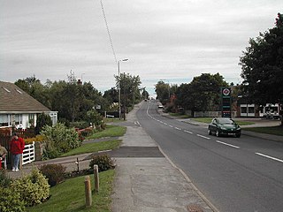
Rainworth is a village in the ceremonial county of Nottinghamshire in the East Midlands of England. It is split between the local government districts of Newark and Sherwood and Mansfield. To the north of Rainworth is the village of Clipstone and to the east are the villages of Bilsthorpe and Farnsfield. Mansfield lies two miles to the west and the village of Blidworth is a mile to the south.

<span class="mw-page-title-main">A617 road</span> Road in England

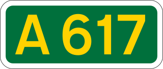
The A617 road runs through the northern East Midlands, England, between Newark-on-Trent and Chesterfield.

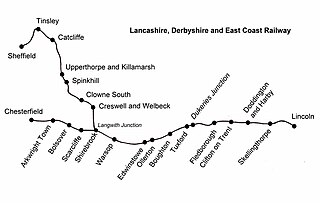
The Lancashire, Derbyshire and East Coast Railway (LD&ECR) was built to connect coalfields in Derbyshire and Nottinghamshire with Warrington and a new port on the Lincolnshire coast. It was a huge undertaking, and the company was unable to raise the money to build its line. With the financial help of the Great Eastern Railway it managed to open between Chesterfield and Lincoln with a branch towards Sheffield from 1896. Despite efforts to promote tourist travel, the passenger business was never buoyant, but collieries were connected to the line, at first and in succeeding years. The Great Eastern Railway, and other main line companies, transported coal to the southern counties, and the company's engines took coal to Immingham in great quantities. The company had a fleet of tank engines.

<span class="mw-page-title-main">Ollerton railway station</span> Former railway station in Nottinghamshire, England

Ollerton railway station is a former railway station in Ollerton, Nottinghamshire, England.

<span class="mw-page-title-main">Mansfield Railway</span> Former local railway service around Mansfield, Nottinghamshire

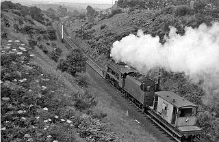
The Mansfield Railway was an eleven-mile railway line in Nottinghamshire, England. It was built to serve collieries opening in the coalfield around Mansfield, and ran between junctions at Clipstone and Kirkby-in-Ashfield on the Great Central Railway. It opened in 1916 and was worked by the GCR. Passenger stations were opened on the line, although, at the date of opening, road bus competition was already dominant.

<span class="mw-page-title-main">Pleasley West railway station</span> Former railway station in Derbyshire, England

Pleasley West was a railway station on the Doe Lea line in Pleasley, Derbyshire, England on the border of Derbyshire and Nottinghamshire. It opened in 1886 and closed to scheduled services in 1930, though it was served by excursion trains until 1964.

The Doe Lea branch is a mothballed railway line in Derbyshire, England. It connected the Derbyshire towns of Chesterfield, Staveley and Bolsover to the Nottinghamshire town of Mansfield. It also had a branch line to Creswell via the Derbyshire town of Clowne.

<span class="mw-page-title-main">Southwell railway station</span> Former railway station in Nottinghamshire, England

Southwell railway station served the town of Southwell in Nottinghamshire, England, from 1847 to 1959. It was a stop on the Rolleston Junction-Mansfield line.

<span class="mw-page-title-main">Kirklington and Edingley railway station</span> Former railway station in Nottinghamshire, England

Kirklington and Edingley railway station was a railway station serving the villages of Edingley and Kirklington in Nottinghamshire, England. It was on the Midland Railway's Rolleston Junction to Mansfield line.

<span class="mw-page-title-main">Farnsfield railway station</span> Former railway station in Nottinghamshire, England

Farnsfield railway station was a railway station serving the village of Farnsfield, Nottinghamshire, England. It was on the Midland Railway's Rolleston Junction to Mansfield line.

<span class="mw-page-title-main">Blidworth and Rainworth railway station</span> Former railway station in Nottinghamshire, England

Blidworth and Rainworth railway station served the villages of Blidworth and Rainworth in Nottinghamshire, England; it was a stop on the Midland Railway's Rolleston Junction to Mansfield line.

Bilsthorpe Moor is a hamlet in the civil parish of Bilsthorpe, in the Newark and Sherwood district of Nottinghamshire, England. It is 120 miles north of London, 13 miles north east of the city of Nottingham, and 5 miles south of Ollerton, and close to the junction of the A614 and A617 roads.

<span class="mw-page-title-main">Southwell Trail</span> Multi-user rail trail in the English county of Nottinghamshire

The Southwell Trail is a 7.5-mile (12.1 km) long multi-user trail, for use on foot, cycle and horseback, that links Bilsthorpe and Southwell in the English county of Nottinghamshire. It uses parts of the track bed of two former railway lines. It has been designated as a Local Nature Reserve.

References

  1. "Nottingham and Lincoln Railway" . Leicestershire Mercury. 3 July 1847. Retrieved 29 August 2016 via British Newspaper Archive.
  2. 1 2 3 4 Gough, John (1989). The Midland Railway - A Chronology. Railway & Canal Historical Society.
  3. 1 2 3 4 5 6 Maund, Richard (5 January 2021). "Rail Chronology: East of Mansfield". Rail Chronology. Retrieved 13 July 2023.
  4. Booth, Chris (5 April 2019). The Lancashire, Derbyshire and East Coast Railway. Vol. 2. Fonthill Media. ISBN   978-1-78155-660-3.
  5. 1 2 3 "Discover Southwell Trail" (PDF). Nottinghamshire County Council. April 2018. Retrieved 13 July 2023.
  6. "The Southwell Railway" . Retrieved 13 July 2023.