| |
Alternative name | Archeological site of Frielas |
---|---|
Location | Frielas, Loures, Lisbon district, Greater Lisbon, Portugal |
Coordinates | 38°49′37″N9°08′38″W / 38.8268747°N 9.1438332°W |
Type | Ruins |
History | |
Cultures | Roman Empire |
Site notes | |
Archaeologists | unknown |
Ownership | Portuguese Republic |
Public access | Private, Frielas |
The Roman Villa of Frielas is located in the parish of Frielas in the municipality of Loures in the Lisbon District of Portugal. It fell under the territory of the Roman settlement of Olisipo, which covered a large area from Lisbon to the south to Torres Vedras in the north. It is believed to have been re-used in the medieval period during the Islamic occupation of Portugal. [1] Excavations began in 1997 and are continuing, over an area of about 3500 square metres. Since 2012 the villa has been classified as a Site of Public Interest.
Its founding resulted from the fertile lands and agricultural harvests in the area, influenced by the confluence of three watercourses that fed the Trancão River in the lowlands of Loures. [2] The settlement was founded sometime between the 3rd and 4th century, and remained occupied until the 7th century. The villa benefited from the proximity of the river, which was navigable, provided a water supply and facilitated fishing. Above all the river ensured that its land was highly fertile. It was about 2 kilometres from the bridge of the road that connected Olisipo to Conímbriga, the large Roman settlement to the north, near present-day Coimbra. [1] [3] [4] [2]
Vestiges from the Middle Ages suggest that the site continued to have an important place in the agrarian community, even as it started to decline. [2] It has been interpreted that the segmentation of the property could have led to the founding of Frielas in the late Moorish occupation (sometime in the 12th century). [2] It is clear that the Roman buildings continued to be occupied in the Medieval era (from the appearance of clay pots and the reorientation of spaces within the compounds, including the construction of silos). [3] [2] [5] From the Moorish period a burial stone was discovered (in the 19th century) a short distance from the archaeological excavation. The Islamic community remained in this area as late as the Reconquista and vestiges until 1147, from this period that are groups of ceramics dating to the 9th and 10th century. [2]
Following the Reconquista, Frielas was transformed into the centre of the region, and the former Roman villa was destroyed by Castilian troops in 1383. This included an important tower, annex the main building, that guarded the road to Lisbon. [2] [6] The residential building was never rebuilt, even after the Count of Ribeira Grande made an attempt in the 17th century. [2] The ruins scarred the property, and only the chapel of Santa Catarina remained, reflecting the archaeological importance. [2]
The first archaeological excavations began in 1997 and on 27 October the municipal council of Loures proposed the classification of the site. [3] Many of the artefacts located on site were collected and stored in the Municipal Museum of Loures. [3]
Yet, nothing ever developed from this proposal and a secondary petition was made on 21 March 2002. [3] On 12 October 2004 the process was opened by the vice-president of the IPPAR Instituto Português do Património Arquitectónico), the national architectural heritage institute. [3] It was followed on 26 January 2012 by a proposal to classify the structures by the DRCLVTejo as a Sítio de Interesse Público (Site of Public Interest) and included in its respective zone of special protection. The proposal was approved on 29 February of the Cultural National Council. [3]
Implanted alongside the ravine of Póvoa, the settlement was formed away from its banks, to escape flooding from the River Trancão, near Sacavém. [2] [7] The Roman village was one of the more important archaeological sites in the municipality of Loures; it reflects the Roman organization and planning that persisted during the period of Imperial Rome until the early Middle Ages. [2]
The site has been explored systematically since 1997. [2] The terra sigillata soils were very settled in this region [8] and the excavated area did not permit a rigorous investigation. Artefacts discovered on the site include fragments of Roman mosaics, discovered in 1997 near the Chapel of Santa Catarina; unearthed and examined, the items dated to the 3rd century, suggesting a longer period of settlement. [2] [9] It is unclear what purpose the place of its discovery was used; the mosaic was part of the principal pavement of one of the principal halls/rooms in the residential building. [2] More recent campaigns identified peristyles of various levels of destruction, and a triclinium, as well as other unidentified structures. [2] There are various walls of differing heights and orientations, making interpretation difficult. [2]
São Domingos de Rana is a civil parish of the Portuguese municipality of Cascais, part of the Greater Lisbon subregion. The population in 2011 was 57,502, in an area of 20.36 km². The parish includes the localities Abóboda, Cabeço de Mouro, Caparide, Matarraque, Outeiro de Polima, Polima, Rana, Talaíde, Tires, Trajouce and Zambujal.
Conímbriga is one of the largest Roman settlements excavated in Portugal, and was classified as a National Monument in 1910. Located in the civil parish of Condeixa-a-Velha e Condeixa-a-Nova, in the municipality of Condeixa-a-Nova, it is situated 2 kilometres (1.2 mi) from the municipal seat and 16 kilometres (9.9 mi) from Coimbra.
Municipium Cives Romanorum Felicitas Julia Olisipo was the ancient name of modern-day Lisbon while it was part of the Roman Empire.
The Roman ruins of São Cucufate is a Romanesque archaeological site, located on the ruins of a Roman-era agricultural farm in the civil parish of Vila de Frades, in the municipality of Vidigueira, in the southern Alentejo, Portugal. The convent, which dates back to Middle Ages, was dedicated to the martyred saint Cucuphas.
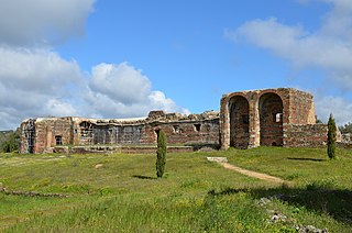
Mirobriga or Mirobriga of the Celts was an ancient town in the westernmost part of Lusitania during the Iron Age and Roman Times that was mentioned by Pliny the Elder and Ptolemy.
The Castle of Paderne is an ancient fortification located in the civil parish of Paderne, municipality of Albufeira, in the Portuguese Algarve. It was constructed in the later 12th century by Berbers, in an area around 7.5 kilometres (4.7 mi) inland.
The Fort of Nossa Senhora da Rocha is a medieval castle situated in the civil parish of Porches, in the municipality of Lagoa in Portuguese Algarve. Inside the fort is the Chapel of Nossa Senhora da Rocha, of uncertain date.
The Roman Ruins of Cerro da Vila are the remnants of a historical villa in the Algarve region of southern Portugal. Its vestiges lie in the vicinity of the resort and marina of Vilamoura, in the civil parish of Quarteira, municipality of Loulé Municipality.
The Roman villa of Vale do Mouro is a Roman settlement situated in the civil parish in the municipality of Meda, excavated since the early 21st century by archaeologists.
The Roman ruins of Santo Andre de Almoçageme is a Portuguese archaeological site located in the rural civil parish of Colares, in the municipality of Sintra. It includes a group of structures with typological, stylistic or historic value, whose structural elements are worthy of preservation.
The archaeological site of Colaride, is a Roman necropolis in a natural cave, located in the Portuguese civil parish of Agualva e Mira-Sintra, municipality of Sintra.
The Roman ruins of Casais Velhos are the remains of a Roman town, in the municipality of Cascais, Lisbon District, Portugal that included baths, two cemeteries, remains of a wall and ceramic artifacts.
The Roman villa of Alto da Cidreira is a Roman villa in the civil parish of Alcabideche, municipality of Cascais, in the Lisbon District of Portugal. Although known since the 1890s, this site has largely been neglected by archaeologists, resulting in destruction of artefacts, including Roman era mosaics, a bath complex and an olive oil cellar.
The Roman villa of Almoinhas is a Roman villa in the civil parish of Loures, municipality of Loures, dating to the first to fifth century AD.
The Roman villa of Outeiro de Polima is a Roman villa in the civil parish of São Domingos de Rana, in the Portuguese municipality of Cascais, dating from the 1st to 6th centuries AD.
The Roman villa of Quinta da Bolacha is a Roman villa in the civil parish of Falagueira-Venda Nova, municipality of Amadora, with an occupation dating from the 3rd and 4th century. It is commonly associated with the nearby Roman aqueduct, as well as the agricultural activities and Chalcedony mining occurring in the district.
The Roman Thermae of Maximinus, are the archaeological ruins of a monumental building and public baths, whose construction was integrated into the urban renewal of the civitas of Bracara Augusta, the Roman provincial capital of Gallaecia. The large public/civic construction consisted of a building, housing the baths and a theatre, although the archaeological excavations continue.
The Archaeological site of Cabeço do Vouga, also known as Castelium Marnelis, is an archaeological site in civil parish union of Trofa, Segadães e Lamas do Vouga, in the municipality of Águeda, in central Portugal. It is classified as a Property of Public Interest, and dates back to the Iron Age.
The Castle of Pena de Aguiar is a medieval castle, alternately the Castle of Aguiar da Pena, situated in the civil parish of Telões, in the municipality of Vila Pouca de Aguiar, in the Portuguese district of Vila Real.
The Roman villa of Freiria is a Roman villa in the civil parish of São Domingos de Rana, in the Portuguese municipality of Cascais.
{{citation}}
: CS1 maint: location missing publisher (link)