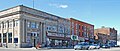
Romeo Historic District | |
 100 block of North Main Street, west side | |
  | |
| Location | Roughly bounded by the corporate lines of Romeo, Michigan |
|---|---|
| Coordinates | 42°48′7″N83°0′51″W / 42.80194°N 83.01417°W |
| NRHP reference No. | 70000281 [1] |
| Significant dates | |
| Added to NRHP | July 8, 1970 |
| Designated MSHS | April 24, 1970 [2] |
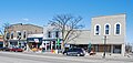
The Romeo Historic District is a historic district roughly bounded by the corporate lines of Romeo, Michigan. It was listed on the National Register of Historic Places in 1970 [1] and designated a Michigan State Historic Site in 1970. [2]