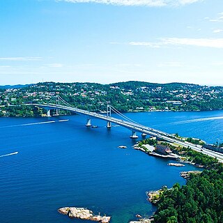
Oddernes is a borough in the municipality of Kristiansand in Vest-Agder county, Norway. The borough covers eastern Kristiansand on the east side of the Topdalsfjorden and the Varodd Bridge. The borough includes the former municipalities of Randesund and Tveit. There was a municipality of Oddernes from 1838 until 1965, but its boundaries were very different from those of the present-day borough.

Oddemarka is a neighborhood in the city of Kristiansand in Vest-Agder county, Norway. It is located in the borough of Lund. The European route E18 highway passes by the neighborhood on the north side. The neighborhood of Presteheia lies to the north of Oddemarka, Kjøita lies to the west, and Marvika lies to the south. Oddemarka school is located in the neighborhood.

Grim is a borough in the city of Kristiansand in Vest-Agder county, Norway. The borough has a population of about 16,000 people and is the second least populated borough in Kristiansand. Grim is located in the northwestern part of the municipality, north of Vågsbygd borough, northwest of Kvadraturen borough, and west of Lund borough. Grim also borders Songdalen and Vennesla municipalities to the west and north, respectively.

Søm is a district in the city of Kristiansand in Vest-Agder county, Norway. With a population of about 9,000 (2014), it is the third largest district in Kristiansand. The district is a part of the borough of Oddernes. Søm has borders with the district of Hånes to the north, the district of Randesund to the east and south, and the Topdalsfjorden to the west. Søm is the second most wealthy district in Kristiansand after Lund. Søm Church is located in the district.
Strømme is a neighborhood in the city of Kristiansand in Vest-Agder county, Norway. It is a part of the Oddernes borough and the district of Søm. It is located next to the Rona and Strømsdalen neighborhoods.

Møvik or Møvig is a neighbourhood in the city of Kristiansand in Vest-Agder county, Norway. The neighborhood is located in the borough of Vågsbygd and in the district of Voiebyen. It's located in the southeast part of the borough along the shore. It lies north of Spinneren and Krooden, southwest of Ternevig, and south of Voie.

Strømsdalen is a neighbourhood in the city of Kristiansand in Vest-Agder county, Norway. It is a part of the Oddernes borough and the district of Søm. The neighborhood is next to the European route E18 highway, just southwest of Vigvoll and north of Stromme. The closest school is Strømme Elementary school. All local bus lines bound to Oddernes goes through Strømsdalen. There is a bank and a pizza restaurant at Strømsdalen, other than that Rona is the closest to a centrum.

Vigvoll is a neighborhood in the city of Kristiansand in Vest-Agder county, Norway. It is a part of the Oddernes borough and the district of Hånes. The neighborhood lies north of the European route E18 highway, west of the Norwegian National Road 41, and east of the Topdalsfjorden. Vigvoll skole is the only junior high at Hånes. Bus line M2 goes though Vigvoll continuing to Hånes, Voiebyen, or Sørlandsparken. It includes a small shopping area known locally as Hånni.

Tømmerstø is a neighbourhood in the city of Kristiansand in Vest-Agder county, Norway. It's located in the borough of Oddernes and in the district of Randesund. The neighborhood of Odderhei lies to the northwest, Holte and Frikstad lie to the northeast, and Kongshavn lies to the southeast.

Bjørndalssletta is a neighborhood in the city of Kristiansand in Vest-Agder county, Norway. It is located in the borough of Lund in the district of Gimlekollen. The neighborhood is located next to the European route E18 highway and the lake Vollevannet. There is a large garden store at Bjørndalssletta. The neighborhood of Oddemarka lies to the southwest, the neighborhood of Presteheia lies to the west, Gimle lies to the north, and the Topdalsfjorden lies to the east.

Nordlia is a neighborhood in the city of Kristiansand in Vest-Agder county, Norway. It is a part of the Oddernes borough and the district of Søm. Nordlia is located on the eastern shore of the Topdalsfjorden at the eastern end of the Varodd Bridge in the northern part of Søm. The neighborhoods of Rona and Strømme lie to the east.
Voie is a neighbourhood in the city of Kristiansand in Vest-Agder county, Norway. The neighborhood is located in the borough of Vågsbygd and in the district of Voiebyen. Voie lies along Norwegian County Road 456 and County Road 457. The only road to the island of Andøya goes past the neighborhood of Voie. It lies northwest of Møvik and northeast of Steindalen.

Gimle is a neighbourhood in the city of Kristiansand in Vest-Agder county, Norway. It's located in the borough of Lund. It is located near the neighborhoods of Oddemarka and Presteheia. The neighborhood of Kjøita lies to the southwest and the neighborhood of Marvika lies to the southeast.

Auglandsbukta is a neighbourhood in the city of Kristiansand in Vest-Agder county, Norway. The neighborhood is located in the borough of Vågsbygd and in the district of Vågsbygd. There is a large marina harbour and park located in the cove of Auglandsbukta. There is also a gas station and some real estate offices at Auglandsbukta. Auglandsbukta is next to Norwegian County Road 456. Augland lies to the west and Skyllingsheia lies to the north.
Frikstad is a neighbourhood in the city of Kristiansand in Vest-Agder county, Norway. It's located in the borough of Oddernes and in the district of Randesund. Randesund Church is located at Frikstad. The neighborhoods of Holte and Tømmerstø lie to the southwest and the neighborhood of Kongshavn lies to the southeast.
Kongshavn is a neighbourhood in the city of Kristiansand in Vest-Agder county, Norway. It's located in the borough of Oddernes and in the district of Randesund. The neighborhood of Frikstad lies to the north and Tømmerstø lies to the northwest. Kongshavn Pier is a large harbor with connections to islands outside of Randesund.
Holte is a neighbourhood in the city of Kristiansand in Vest-Agder county, Norway. It's located in the borough of Oddernes and in the district of Randesund. The neighborhood of Tømmerstø lies to the south and Frikstad lies to the east. Holte Junior High is the only junior high in Randesund.
Slettheitoppen or Øvre Slettheia is a neighbourhood in the city of Kristiansand in Vest-Agder county, Norway. It is located in the borough of Vågsbygd and in the district of Slettheia. The neighborhood lies west of Trane and northwest of Nedre Slettheia. The Øvre Slettheia skole is an elementary school in the neighbourhood.

Gillsvannet or Gjelsvannet is a freshwater lake in the municipality of Kristiansand in Vest-Agder county, Norway. The 1.05-square-kilometre (260-acre) lake is located about 5 kilometres (3.1 mi) northeast of downtown Kristiansand, along to County Road 452. The lake lies about 300 metres (980 ft) west of the Topdalsfjorden, at an elevation of about 1 metre above sea level. There is a practice range for kayaking on the lake as well as many areas used for swimming during the summer season. The Gimlekollen district lies on the southern shore of the lake and the village of Justvik lies just north of the lake.


