Rongel Point

Last updated
Location of Livingston Island in the South Shetland Islands Livingston-Island-location-map.png
Location of Livingston Island in the South Shetland Islands
Rongel Point from Bulgarian Beach Rongel-Point.jpg
Rongel Point from Bulgarian Beach
1996 topographic map of the area featuring Rongel Point Central-Eastern-Livingston-Map.png
1996 topographic map of the area featuring Rongel Point
Livingston-Island-Map-2010-15.png

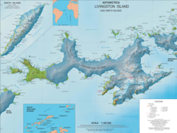
Rongel Point (Nos Rongel \'nos ron-'zhel\) is an ice-covered headland on the northwest coast of South Bay, Livingston Island in the South Shetland Islands, Antarctica. The area was visited by 19th century sealers operating from nearby Johnsons Dock.

Contents

The feature takes its name from nearby Rongel Reef named after the Brazilian Navy research vessel Ary Rongel, in recognition of her logistic support for the Bulgarian Antarctic campaigns.

Location

Ary Rongel Point is located at 62°37′00″S60°24′48″W / 62.61667°S 60.41333°W / -62.61667; -60.41333 , which is 1.3 km northeast of Smolyan Point, 4 km west of Aleko Point and 3.5 km northwest of Hespérides Point. Bulgarian mapping from a topographic survey of the region made from 8 December 1995 to 8 February 1996; the coastal configuration in the area was altered subsequently as a result of Pimpirev Glacier's retreat in the late 20th and early 21st centuries.

Maps

References


This article includes information from the Antarctic Place-names Commission of Bulgaria which is used with permission.