Roosevelt station (CTA Douglas branch)

Last updated

ROOSEVELT
 
1200S
1700W
Former Chicago 'L' rapid transit station
General information
Location1710 West Roosevelt Road
Chicago, Illinois, US [1]
Coordinates 41°52′03″N87°40′10″W / 41.867402°N 87.669466°W
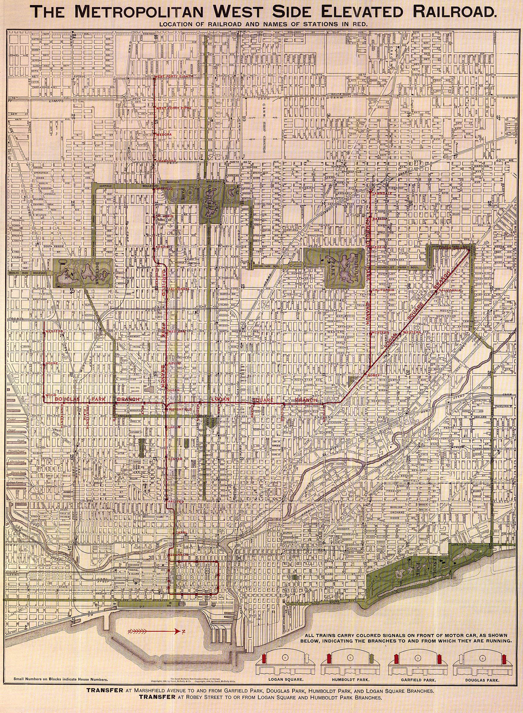
 / 41.867402; -87.669466
Line(s) Douglas Park branch
Platforms2 side platforms
Tracks2
Construction
Structure typeElevated
History
OpenedApril 28, 1896
ClosedMay 3, 1952
Passengers
195153,208Decrease2.svg 2.64%(CTA)
Former services
Preceding station Chicago "L" Following station
14th Place
Closed 1951 [lower-alpha 1]
toward Oak Park
Douglas branch Polk
toward Marshfield
Location
Roosevelt station (CTA Douglas branch)

Roosevelt, originally 12th, was a rapid transit station on the Chicago "L"'s Douglas Park branch between 1896 and 1952. Constructed by the Metropolitan West Side Elevated Railroad, it was one of the first stations opened on the branch in April 1896.

Contents

One of the busiest stations on the branch for the first decades of its existence, its ridership became lackluster in the 1920s and started declining precipitously in the latter half of that decade. Although several other stations were closed in a December 1951 service revision to the branch, Roosevelt was spared that fate; instead, its service and facilities were drastically reduced and it became a "partial-service" station. This proved short-lived, however, and the station closed altogether in 1952.

History

The Douglas Park branch opened on April 28, 1896, significantly later than the other branches of the Metropolitan West Side Elevated Railroad. One of its stations was located on 12th Street. [1] The street was renamed Roosevelt Road in May 1919 to honor the recently-deceased Theodore Roosevelt. [3]

Douglas service was significantly streamlined on December 9, 1951, part of the Chicago Transit Authority (CTA)'s broader overhaul of the Metropolitan's lines. Skip-stop was instituted on the Douglas and Garfield branches, and several low-performing stations on the Douglas branch were closed. Roosevelt, Wood and Douglas Park were turned into "partial service stations". [2] These stations lost their agents at all hours, entrance being instead through coin-operated turnstiles. Trains stopping at partial service stations did not stop at Polk, 18th, or California. [1]

Partial service proved to be short-lived for Roosevelt, however; the CTA closed it and Douglas Park altogether on May 3, 1952. [1]

Station details

Design and infrastructure

Roosevelt was similar to other stations on the Douglas branch, with a brick Craftsman-style station house at street level. It had two wooden side platforms with cast-iron canopies with hipped roofs of corrugated, in common with the other stations on the Metropolitan's lines. [1]

Operations

During the time of partial service stations, trains stopped at such stations every 15 minutes during rush hours and every 30 minutes at other times. [1]

Ridership

In 1900, 12th [lower-alpha 2] was the highest-ridership station on the Douglas Park branch, with 611,758 riders. It would hold this position until 1904, when it was surpassed by Hoyne. Ridership peaked at 755,555 passengers in 1907, a year that also saw the peak of every stations' ridership between 12th and Hoyne, inclusive. [5] Still the third-most popular Douglas Park station in 1907, by 1919 it had dropped to fifth place and by 1929 had become the sixth-least ridden station as riders moved west on the branch. [6] Ridership last exceeded 700,000 passengers in 1910, 500,000 in 1924, 300,000 in 1929, and 200,000 in 1931. [7]

In its last full year of operation, 1951, Roosevelt accommodated 53,208 passengers, a 2.64 percent decrease from the 54,649 passengers of 1950. Its relative ranking of Douglas ridership increased, however; in 1950, it was second only to Kenton  a station that had no street access and abutted a railway rather than an actual street, [8] serving 19,826 passengers in its disuse, whereas in 1951 it surpassed Kenton, the opened-in-December Central Park, and 14th Place on the branch. [9] Ridership is not available for any CTA stations in 1952. [9]

Notes

  1. Wood after 1951. [1] [2]
  2. Convention in Chicago is to omit "Street" and "Avenue" (though not "Place", "Drive", etc.) from rapid transit station names, a practice which has it roots as early as 1898. [4]

Related Research Articles

<span class="mw-page-title-main">Blue Line (CTA)</span> Rapid transit line in Chicago

The Blue Line is a 26.93-mile-long (43.34 km) Chicago "L" line which extends through The Loop from O'Hare International Airport at the far northwest end of the city, through downtown via the Milwaukee–Dearborn subway and across the West Side to its southwest end at Forest Park, with a total of 33 stations. At about 27 miles, it is the longest line on the Chicago "L" system and second busiest, and one of the longest local subway/elevated lines in the world. It has an average of 64,978 passengers boarding each weekday in 2022.

<span class="mw-page-title-main">Western station (CTA Blue Line O'Hare branch)</span> Chicago rapid transit station

Western is an elevated rapid transit station on the Chicago "L"'s Blue Line, where it is located on the O'Hare branch. The station, opened in 1895, is located within the Bucktown neighborhood in the larger Logan Square community area. It has two side platforms at track level with a station house at street level.

<span class="mw-page-title-main">Damen station (CTA Blue Line)</span> Rapid transit station in Chicago

Damen is a rapid transit station on the Chicago "L", currently serving the O'Hare branch of its Blue Line. Opened on May 6, 1895, as Robey, it is the oldest station on the Blue Line. The station serves the popular Bucktown and Wicker Park neighborhoods, and is consistently in the top 40 highest-ridership "L" stations. It has two wooden side platforms and a brick station house at street level. The west platform, serving southbound trains, contains a tower that has never been used but is a relic of the station's past. The station is served by three bus routes on Damen, Milwaukee, and North Avenues, which are each descended from streetcar lines on those streets in the early 20th century. The Blue Line has owl service; while the surrounding streetcar lines also had owl service in the early 20th century, the modern bus services do not.

<span class="mw-page-title-main">Western station (CTA Blue Line Forest Park branch)</span> Chicago "L" station

Western is a station on the 'L' system, serving the Blue Line's Forest Park branch. It is located in the median of the Eisenhower Expressway. It serves the Near West Side neighborhood and Crane Tech High School. The station is also located about 1 mile (1.6 km) north of the Western Avenue commuter railroad station.

<span class="mw-page-title-main">Pulaski station (CTA Blue Line)</span> Chicago "L" station

Pulaski is a station on the Chicago 'L' system, serving the Blue Line's Forest Park branch. The station is located in the median of the Eisenhower Expressway and serves the West Garfield Park neighborhood. A long ramp connects the platform to the station house on the Pulaski Road overpass. There was originally a similar entrance from the Keeler Avenue overpass; the entrance from Keeler was closed to cut costs on January 15, 1973, but retained as an exit, and the exit was fully closed on December 28, 1978. The structure for this exit still stands but it is closed to the public.

<span class="mw-page-title-main">Metropolitan main line</span> Former rapid transit line in Chicago

The Metropolitan main line was a rapid transit line of the Chicago "L" system from 1895 to 1958. It ran west from downtown to a junction at Marshfield station. At this point the Garfield Park branch continued westward, while the Douglas Park branch turned south, and the Logan Square branch turned north with the Humboldt Park branch branching from it. In addition to serving the Chicago "L", its tracks and those of the Garfield Park branch also carried the Chicago Aurora and Elgin Railroad, an interurban that served Chicago's western suburbs, between 1905 and 1953.

<span class="mw-page-title-main">Cermak branch</span>

The Cermak branch, formerly known as the Douglas branch, is a 6.6 mi (10.6 km) long section of the Pink Line of the Chicago "L" system in Chicago, Illinois. It was built by the Metropolitan West Side Elevated west of the Loop. As of February 2013, it serves an average of 17,474 passengers every weekday. The branch serves the Near West Side, Pilsen, Lower West Side, South Lawndale, and North Lawndale neighborhoods of Chicago, and the west suburb Cicero, Illinois. The branch operates from 4:05 a.m. to 1:25 a.m., weekdays, and Saturdays from 5:05 a.m. to 1:25 a.m., and Sundays from 5:00 a.m. to 1:25 a.m., including holidays.

The Humboldt Park branch was a rapid transit line which was part of the Chicago "L" system from 1895 to 1952. The branch served the West Town and the Humboldt Park neighborhoods of Chicago and consisted of six elevated stations. It opened on July 29, 1895, and closed on May 4, 1952.

The Garfield Park Branch was a rapid transit line which was part of the Chicago "L" system from 1895 to 1958. The branch served Chicago's Near West Side, East Garfield Park, West Garfield Park, and Austin neighborhoods, and the suburbs of Oak Park, and Forest Park, and consisted of twenty-two stations. It opened on June 19, 1895 and closed on June 22, 1958, when it was replaced by the Congress branch of the Blue Line.

<span class="mw-page-title-main">Logan Square branch</span> Rapid transit line in Chicago

The Logan Square branch was an elevated rapid transit line of the Chicago "L", where it was one of the branches of the Metropolitan West Side Elevated Railroad. Diverging north from the Metropolitan's main line west of Marshfield station, it opened in 1895 and served Chicago's Logan Square and West Town neighborhoods. North of Damen station, the Humboldt Park branch diverged from the Logan Square branch, going west to serve Humboldt Park. The original Logan Square branch was separated into several sections in 1951, some of which remain in revenue service as of 2023.

<span class="mw-page-title-main">Lake Street Transfer station</span> Rapid transit station in Chicago (1913–1951)

The Lake Street Transfer station was a rapid transit station on the Chicago "L", serving as a transfer station between its Lake Street Elevated Railroad and the Logan Square branch of its Metropolitan West Side Elevated Railroad. Located where the Logan Square branch crossed over the Lake Street Elevated, it was in service from 1913 to 1951, when it was rendered obsolete by the opening of the Dearborn Street subway.

<span class="mw-page-title-main">Marshfield station</span> Rapid transit station in Chicago, 1895–1954

Marshfield was a rapid transit station on the Chicago "L" in service between 1895 and 1954. Constructed by the Metropolitan West Side Elevated Railroad, it was the westernmost station of the Metropolitan's main line, which then diverged into three branches. Marshfield was also served by the Aurora Elgin and Chicago Railway (AE&C) and its descendant the Chicago Aurora and Elgin Railroad (CA&E), an interurban, between 1905 and 1953.

<span class="mw-page-title-main">Madison station (CTA)</span> Rapid transit station in Chicago, 1895–1951

Madison was a rapid transit station on the Chicago "L"'s Metropolitan West Side Elevated Railroad, serving its Logan Square branch from 1895 to 1951. The station was typical of those constructed by the Metropolitan, with a Queen Anne station house and two wooden side platforms adjacent to the tracks. For much of its existence, Madison served the nearby sports arena Chicago Stadium.

<span class="mw-page-title-main">Laflin station</span> Rapid transit station in Chicago, 1895–1951

Laflin was a rapid transit station operated by the Chicago "L"'s Metropolitan West Side Elevated Railroad and located on its main line. The station existed from 1895 to 1951, when it was closed due to low ridership. The entire main line would soon be demolished for construction of the Eisenhower Expressway and its Congress Line, and the niche served by the Laflin would be filled by an entrance on the new line's Racine station.

Canal was a rapid transit station located on the Metropolitan main line of the Chicago "L" that was in service from 1895 to 1958, when the entire main line was replaced by the Congress Line located in the median of the nearby Eisenhower Expressway. Starting in 1927, the interurban Chicago Aurora and Elgin Railroad (CA&E) also served the station, continuing until 1953. The station connected with Chicago's Union Station, which was one of the city's rail terminals. One of the busiest stations on the Metropolitan's routes, and of the "L" in general, it opened a second entrance on Clinton Street in 1914.

Division was a rapid transit station on the Chicago "L"'s Logan Square branch, one of several branches of the Metropolitan West Side Elevated Railroad. Located on Division Street, the station was constructed by the Metropolitan in the early 1890s and began service on May 6, 1895.

Grand was a rapid transit station on the Chicago "L"'s Logan Square branch, one of the several branches of the Metropolitan West Side Elevated Railroad. Located on Grand Avenue, the station was constructed by the Metropolitan in the early 1890s and began service on May 6, 1895.

14th Place was a rapid transit station on the Chicago "L"'s Douglas Park branch between 1896 and 1951. Constructed by the Metropolitan West Side Elevated Railroad, it was one of the first stations opened on the branch in April 1896.

<span class="mw-page-title-main">St. Louis station (CTA Garfield Park branch)</span> Rapid transit station in Chicago, 1895–1958

St. Louis was a rapid transit station on the Chicago "L" between 1895 and 1953. It was constructed by the Metropolitan West Side Elevated Railroad and served its Garfield Park branch. The Chicago Aurora and Elgin Railroad (CA&E), an interurban serving Chicago's western suburbs, also used the Garfield Park branch's tracks in 1905. To accommodate the mixing of the fast interurban and slow "L" service on a two-track line, two crossovers were installed on either side of the St. Louis station to let CA&E trains pass "L" trains in 1911.

Kedzie was a rapid transit station on the Chicago "L", serving the Garfield Park branch of its Metropolitan West Side Elevated Railroad, from 1895 to 1958. Between 1905 and 1953, it also served the Chicago Aurora and Elgin Railroad (CA&E), an interurban using Garfield Park tracks, between 1905 and 1953.

References

  1. 1 2 3 4 5 6 7 Garfield, Graham. "Roosevelt". Chicago-L.org. Retrieved December 31, 2022.
  2. 1 2 "Revise Douglas and Garfield 'L' Service Dec. 9". Chicago Tribune. December 1, 1951. Retrieved January 1, 2023.
  3. Broden, Scott (February 19, 1995). "By The Numbers Where Did Those Street Designations Come From?". Chicago Tribune. Archived from the original on January 31, 2013. Retrieved January 1, 2023.
  4. The Metropolitan West Side Elevated Railroad (Map). Metropolitan West Side Elevated Railroad. 1898. Retrieved January 1, 2023 via Chicago-L.org.
  5. CTA 1979, p. 18
  6. CTA 1979, pp. 18–20
  7. CTA 1979, pp. 19–21
  8. Garfield, Graham. "Kenton". Chicago-L.org. Retrieved January 1, 2023.
  9. 1 2 CTA 1979, p. 23

Works cited