
Beaghmore is a complex of early Bronze Age megalithic features, stone circles and cairns, 8.5 miles north west of Cookstown, County Tyrone in Northern Ireland, on the south-east edge of the Sperrin Mountains.
Carrowmore is a large group of megalithic monuments on the Coolera Peninsula to the west of Sligo, Ireland. They were built in the 4th millennium BC, during the Neolithic. There are thirty surviving tombs, making Carrowmore one of the largest clusters of megalithic tombs in Ireland, and one of the 'big four' along with Carrowkeel, Loughcrew and Brú na Bóinne. Carrowmore is the heart of an ancient ritual landscape which is dominated by the mountain of Knocknarea to the west. It is a protected National Monument.
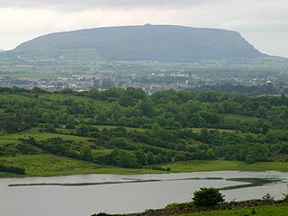
Knocknarea is a large prominent hill west of Sligo town in County Sligo, Ireland, with a height of 327 metres (1,073 ft). Knocknarea is visually striking as it has steep limestone cliffs and stands on the Cúil Irra peninsula overlooking the Atlantic coast. At the summit is one of Ireland's largest cairns, known as Queen Maeve's Cairn, which is believed to contain a Neolithic passage tomb. In recent years there has been concern that the ancient cairn, a protected National Monument, is being damaged by climbers. There are also remains of several smaller tombs on the summit. Knocknarea overlooks the Carrowmore tombs and is thought to have been part of an ancient ritual landscape.

New Luce is a civil parish in Dumfries and Galloway, south-west Scotland. It lies in the traditional county of Wigtownshire, and is about 10 miles (16 km) in length and 5 miles (8.0 km) in breath, being the upper part of the original Glenluce Parish. New Luce is shown as a civil parish on John Ainslie's county map of 1782.

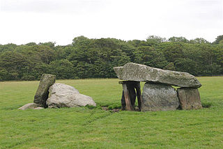
Cohaw is a Neolithic double court tomb located 4 kilometres south-east of Cootehill, County Cavan, Ireland. The tomb lies on a ridge overlooking a small tributary of the Annagh river.
Goodaver, Goodaver stone circle or Goodaver circle is a stone circle located in the parish of Altarnun, near Bolventor on Bodmin Moor in Cornwall, UK.
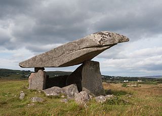
Kilclooney More is a townland in the northwest of Ireland in coastal County Donegal. It is situated halfway between Narin and Ardara at the R261 on the Loughrea Peninsula.
The Pettigarths Field Cairns is a Neolithic site in the parish of Nesting, northeastern Whalsay, in the Shetland islands of Scotland. It is located approximately 140 metres (460 ft) to the northwest of Benie Hoose. The site contains upright stones as well as masonry. The south cairn is roughly 6 metres (20 ft) square, with an eastern entrance passage and circular chamber about 2 metres across. 4 metres (13 ft) to the north is a round cairn, 4.5 metres (15 ft) in diameter, with a rectangular cist. The two cairns are located on a rise, about 140 metres (460 ft) northwest of Benie Hoose.

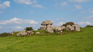
Creevykeel Court Tomb is one of the finest examples of a court tomb remaining in Ireland. The monument is located in the N15 Donegal to Sligo road, 50 meters north of Creevykeel cross-roads close to Cliffoney village in County Sligo. The original name for the Creevykeel monument is Caiseal an Bhaoisgin, the Fort of Bhaoisgin, Tobar an Bhaoisgin being the name of the well near the cairn. A second megalithic monument existed 300 meters to the north, but it was demolished around 1890.
Presaddfed Burial Chamber is a listed monument in Anglesey, north Wales, comprising two Neolithic chamber tombs. It is a scheduled ancient monument and is located a short distance northwest of Bodedern. It is maintained by Cadw.
Seefin Passage Tomb is an empty passage grave and National Monument located atop Seefin Hill, County Wicklow, Ireland.
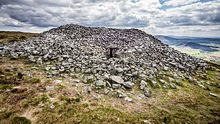
Rathcoran is a passage grave and hillfort and National Monument located atop Baltinglass Hill, County Wicklow, Ireland.

Heapstown Cairn is a cairn and National Monument located in County Sligo, Ireland.
Carrowreagh Court Tomb is a court cairn and National Monument located in County Sligo, Ireland.
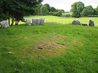
Glebe Stone Circles are standing stones and National Monument located in County Mayo, Ireland.
Carbad More is a double court cairn and National Monument located in County Mayo, Ireland.

Kilcashel Stone Fort is a double court cairn and National Monument located in County Mayo, Ireland, 800m southeast of Kilmovee. The last surviving member of three stone forts in the area, it's estimated to have been constructed between 2,500 and 500BC.

The court tomb of Behy is a megalithic monument in the townland of the same name, near Belderrig in the north of County Mayo, Ireland. The monument is located within the Céide Fields complex, 150 meters above sea level on the slope of Maumakeogh hill, and is the most westerly of the thirty or so tombs in the Killala group. The site commands wide views across the sea to the north and to the Stags of Broadhaven. The monument is located 500 meters west of the Céide Fields Visitor Centre and is on private property.

Kealkill stone circle is a bronze age axial five-stone circle located just outside the village of Kealkill, County Cork in southwest Ireland. When it was excavated in 1938 it was thought the crucial axial stone indicated an alignment to the north, contrary to the general alignment of such stone circles to the southwest. However, later archaeologists have thought it is the comparatively insignificant stone to the southwest that is the axial stone. There are two associated standing stones nearby, one of which had fallen and was re-erected in 1938.
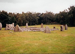
Loanhead of Daviot stone circle is a recumbent stone circle in Aberdeenshire in lowland northeast Scotland. The circle consists of the recumbent stone with its flankers and a complete set of eight orthostats about 21 metres (69 ft) in diameter surrounding a low kerbed ring cairn which has an open court. However, the present appearance has in part been produced by substantial restoration after archaeological excavation in 1934, and in 1989 by the removal of the stones covering the central court.
