
Dudley is a large market town and administrative centre in the county of West Midlands, England, 5.5 miles (8.9 km) southeast of Wolverhampton and 8 miles (13 km) northwest of Birmingham. Historically an exclave of Worcestershire, the town is the administrative centre of the Metropolitan Borough of Dudley; in 2011 it had a population of 79,379. The Metropolitan Borough, which includes the towns of Stourbridge and Halesowen, had a population of 312,900. In 2014 the borough council named Dudley as the capital of the Black Country.

The Metropolitan Borough of Dudley is a metropolitan borough of West Midlands, England. It was created in 1974 following the Local Government Act 1972, through a merger of the existing Dudley County Borough with the municipal boroughs of Stourbridge and Halesowen.

The Priory Estate is a housing estate in Dudley, West Midlands, England, which has largely been developed since 1929.

St James Academy is a secondary school located in Dudley, West Midlands, England for pupils 11 to 16 years. It is also a specialist Arts College.
Dudley Girls' High School was a selective higher education school which provided education for girls aged 11–18 years.
The Blue Coat School was a mixed secondary school located in Dudley, England. It was opened in 1869 within buildings in Bean Road, several hundred yards east of Dudley town centre. It expanded in 1970 to take in the buildings of Rosland Secondary School, Beechwood Road, at nearby Kates Hill, but the Bean Road site was still used for some lessons until 1981, when it was finally declared redundant after 112 years and sold to make way for a residential development.

Kates Hill, or Kate's Hill, is a residential area in Dudley, West Midlands, England.
St Thomas's Community Network is a community facility which serves the St Thomas's parish of Dudley, West Midlands, England.

Aldworth School is a secondary school, formerly Aldworth Science College, after Richard Aldworth Community School, in Basingstoke, Hampshire, England.
Pedmore is a residential suburb of Stourbridge in the West Midlands of England. It was originally a village in the Worcestershire countryside until extensive housebuilding during the interwar years saw it gradually merged into Stourbridge. The population of the appropriate Dudley Ward taken at the 2011 census was 12,471.
Cradley High School was a secondary school located in the Cradley area of Halesowen, which is a village in the West Midlands county of England. It is situated in the west end of Halesowen near the borders with Stourbridge and Brierley Hill, namely Homer Hill. As of 2006, the school had 606 pupils on roll.
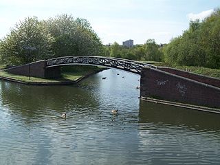
The present day Bumble Hole Branch Canal and Boshboil Branch surround Bumble Hole, a water-filled clay pit, in Bumble Hole and Warren's Hall Nature Reserve, Rowley Regis, West Midlands, England. They formed a looped part of the original Dudley No. 2 Canal until the opening of the Netherton Tunnel in 1858 when the loop was bypassed by a new cut, in line with the new tunnel. Part of the bypassed canal loop, which surrounds Bumble Hole, is now in-filled giving access to the pool of Bumble Hole. An area next to the Bumble Hole and Dudley canals is the Bumble Hole Local Nature Reserve.
Thorns Collegiate Academy is a coeducational secondary school located in Brierley Hill, West Midlands, England.
Park Secondary School was a secondary school located in Dudley, West Midlands, England.
Wolverhampton Street School was a secondary school located in Dudley, Worcestershire, England.
The Wren's Nest Estate is a housing estate located to the north west of the town centre of Dudley, West Midlands, England.
Ludlow College is a sixth form college situated in the heart of Ludlow, Shropshire, England. It now forms part of the Herefordshire and Ludlow College, though retains its own identity.
This article details a number of defunct schools that were once located in the Metropolitan Borough of Dudley. For details of currently operating schools in the area, please see: List of schools in Dudley.
This article details a number of defunct schools that were once located in Sandwell in the West Midlands of England. For details of currently operating schools in Sandwell, please see: List of schools in Sandwell.

Weoley Castle is the remains of a fortified manor house located in the Birmingham district of Weoley Castle, a primarily residential area, in the English West Midlands. Owned by Birmingham City Council and administered as a community museum by Birmingham Museums Trust, it is a Grade II listed building and a Scheduled monument. The castle was on Historic England's Heritage at Risk Register, but was removed in 2009 following repair work.