
Dudley is a market town in the West Midlands, England, 6 miles (9.7 km) southeast of Wolverhampton and 8 miles (13 km) northwest of Birmingham. Historically part of Worcestershire, the town is the administrative centre of the Metropolitan Borough of Dudley. In the 2011 census, it had a population of 79,379. The Metropolitan Borough, which includes the towns of Stourbridge and Halesowen, had a population of 312,900. In 2014, the borough council named Dudley as the capital of the Black Country.

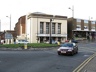
Stourbridge is a market town in the Metropolitan Borough of Dudley in the West Midlands, England, situated on the River Stour. Historically in Worcestershire, it was the centre of British glass making during the Industrial Revolution. The 2011 UK census recorded the town's population as 63,298.

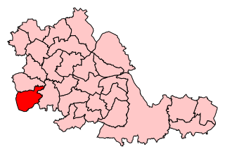
The Metropolitan Borough of Dudley is a metropolitan borough of West Midlands, England. It was created in 1974 following the Local Government Act 1972, through a merger of the existing Dudley County Borough with the municipal boroughs of Stourbridge and Halesowen.

Brierley Hill is a town and electoral ward in the Metropolitan Borough of Dudley, West Midlands, England, 3 miles south of Dudley and 1 mile north of Stourbridge. Part of the Black Country and in a heavily industrialised area, it has a population of 13,935 at the 2011 census. It is best known for glass and steel manufacturing, although industry has declined considerably since the 1970s. One of the largest factories in the area was the Round Oak Steelworks, which closed down and was redeveloped in the 1980s to become the Merry Hill Shopping Centre. Brierley Hill was originally in Staffordshire.
Sedgley is a town in the north of the Metropolitan Borough of Dudley, in the West Midlands, England.

Kingswinford is a town of the Metropolitan Borough of Dudley in the English West Midlands, situated 5 miles (8.0 km) west-southwest of central Dudley. In 2011 the area had a population of 25,191, down from 25,808 at the 2001 Census.

Amblecote is an affluent urban village in the Metropolitan Borough of Dudley in the West Midlands, England. It lies immediately north of the historic town of Stourbridge on the southwestern edge of the West Midlands conurbation. Historically, Amblecote was in the parish of Oldswinford, but unlike the rest of the parish it was in Staffordshire, and as such was administered separately.

A civil parish is a subnational entity, forming the lowest unit of local government in England. There are 21 civil parishes in the ceremonial county of West Midlands, most of the county being unparished; Dudley, Sandwell, Walsall and Wolverhampton are completely unparished. At the 2001 census, there were 89,621 people living in the parishes, accounting for 3.5 per cent of the county's population.

Dudley North is a constituency represented in the House of Commons of the UK Parliament since 2019 by Marco Longhi, of the Conservative Party.

Dudley South is a constituency represented in the House of Commons of the UK Parliament since 2015 by Mike Wood of the Conservative Party.
Stourbridge is a constituency in West Midlands represented in the House of Commons of the UK Parliament since 2019 by Suzanne Webb, a member of the Conservative Party. The seat was previously held by Margot James, a Conservative who lost the whip in September and October 2019 and did not run for reelection.
Wordsley is a suburban area of Stourbridge in the West Midlands, England. It is part of the Metropolitan Borough of Dudley and falls into the Stourbridge (DY8) postcode and address area, being just north of the River Stour. Wordsley is part of the Dudley South Parliamentary constituency. It is bordered by open countryside to the west, Kingswinford to the North, Brierley Hill to the East and Stourbridge to the South.
The County Borough of Dudley was a local government district in the English Midlands from 1865 to 1974. Originally a municipal borough, it became a county borough in 1889, centred on the main town centre of Dudley, along with the suburbs of Netherton and Woodside. Although surrounded by Staffordshire, the borough was associated with Worcestershire for non-administrative purposes, forming an exclave of the county until 1966, when it was transferred to Staffordshire after an expansion of the borough boundaries. Following local government reorganization in 1974, Dudley took in the boroughs of Halesowen and Stourbridge to form the present-day Metropolitan Borough of Dudley, in the newly formed West Midlands county.
Halesowen and Stourbridge was a parliamentary constituency in the West Midlands, which returned one Member of Parliament (MP) to the House of Commons of the Parliament of the United Kingdom from February 1974 until it was abolished for the 1997 general election.
Dudley West was a parliamentary constituency, centred on the town of Dudley in the West Midlands. It existed from 1974 to 1997, returning one Member of Parliament (MP) to the House of Commons of the Parliament of the United Kingdom by the first past the post system.
Wall Heath is a suburban village in the Dudley Metropolitan Borough in the West Midlands of England. It is located on the A449 road, approximately 1.5 miles northwest of Kingswinford, 5 miles west of Dudley Town Centre and 9 miles north of Kidderminster. It forms part of the West Midlands-South Staffordshire border.

The A491 is an A road in Zone 4 of the Great Britain numbering scheme.