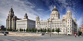
Merseyside is a ceremonial and metropolitan county in North West England. It borders Lancashire to the north, Greater Manchester to the east, Cheshire to the south, the Welsh county of Flintshire across the Dee Estuary to the southwest, and the Irish Sea to the west. The largest settlement is the city of Liverpool.

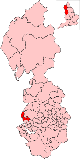
The Metropolitan Borough of Sefton is a metropolitan borough of Merseyside, England. It was formed on 1 April 1974, by the amalgamation of the county boroughs of Bootle and Southport, the municipal borough of Crosby, the urban districts of Formby and Litherland, and part of West Lancashire Rural District. It consists of a coastal strip of land on the Irish Sea which extends from Southport in the north to Bootle in the south, and an inland part to Maghull in the south-east, bounded by the city of Liverpool to the south, the Metropolitan Borough of Knowsley to the south-east, and West Lancashire to the east.

Great Crosby is an area of the town of Crosby, in the Metropolitan Borough of Sefton, Merseyside, England and is historically, part of Lancashire.

Litherland is a town in the Metropolitan Borough of Sefton, Merseyside. Until 1899 it was within the historic county of Lancashire. It was an urban district, which included Seaforth and Ford. It neighbours Waterloo to the north, Seaforth to the west, and Bootle to the south and is approximately 5 miles (8.0 km) north of Liverpool city centre.

Formby is a town and civil parish in the Metropolitan Borough of Sefton, Merseyside, England.

Crosby is a coastal town in the Metropolitan Borough of Sefton, Merseyside, England. Historically in Lancashire, it is north of Bootle, south of Southport and Formby, and west of Netherton. It abuts the areas of Blundellsands to the north and Waterloo to the south. It is approximately 6 miles (9.6 km) north of Liverpool City Centre.

Netherton is an area of the Metropolitan Borough of Sefton, in Merseyside, England.

The Liverpool, Crosby and Southport Railway was a British railway company, which opened a line in 1848 between Southport and Waterloo, extending into Liverpool in 1850. The company was acquired by the Lancashire and Yorkshire Railway in 1855. The line is still open.

Crosby was a constituency in Merseyside, represented in the House of Commons of the Parliament of the United Kingdom from 1950 until 2010. It elected one Member of Parliament (MP) by the first past the post system of election.
Sefton Central is a constituency represented since its creation in 2010 by Bill Esterson of the Labour Party.
Woodvale railway station was a railway station located in Woodvale, Merseyside, England.
The Southport & Cheshire Lines Extension Railway was an early British railway company operating in the then county of Lancashire. It was constructed to link the Cheshire Lines Committee railway at Aintree to Southport. It operated from 1884 to 1952.

Lydiate railway station was a station located on the Southport & Cheshire Lines Extension Railway off Carr Lane, just outside Lydiate. The Merseyside and Lancashire border runs down the stream alongside Altcar Lane, which runs parallel to the line.
Sefton and Maghull railway station was a station located on the Southport & Cheshire Lines Extension Railway on Sefton Lane, Maghull, Merseyside, England.

Sefton Council, or Sefton Metropolitan Borough Council, is the local authority of the Metropolitan Borough of Sefton in Merseyside, England. It is a metropolitan borough council and provides the majority of local government services in the borough. The council has been a member of the Liverpool City Region Combined Authority since 2014.
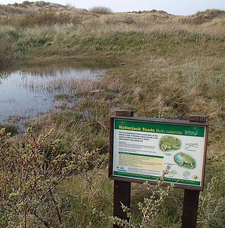
Sefton Coast is a 4605.3 hectare site of special scientific interest in England which stretches for 12 miles (20 km) between Southport and Waterloo, ending with Crosby Beach. The site was notified in 2000 for both its biological and geological features. It has species such as grass of Parnassus, wild orchids, rare butterflies, sand lizards, natterjack toads and waders.

South Lancashire is a geographical county area, used to indicate the southern part of the historic county of Lancashire, today without any administrative purpose. The county region has no exact boundaries but generally includes areas that form the West Derby Hundred and the Salford Hundred, both of which formed the South Lancashire parliament constituency from 1832. This constituency was further divided in 1868 forming the South East Lancashire and South West Lancashire constituencies. Today the area is still recognized by the government and organisations, including the National Health Service. South Lancashire includes the cities of Manchester and Liverpool.