From 1918 to 1950 Seaforth was within the Parliamentary constituency known as Waterloo, a safe seat for the Conservative Party, and then until 2010 within the Crosby constituency, whose MP from 1997 to 2010 was Claire Curtis-Thomas, of the Labour Party. Prior to her election the Crosby seat was generally considered a Conservative Party stronghold, like its predecessor seat, with Tory MPs elected at every election, except for the 1981 Crosby by-election, when Shirley Williams of the Social Democratic Party was elected. As a result of boundary revisions for the 2010 general election, the Crosby constituency was abolished and Seaforth was included in the expanded Bootle constituency. The district has been represented by Labour MP Peter Dowd since 2015.
For elections to Sefton Council, Seaforth is within the Church electoral ward and is represented by three councillors, two from the Labour Party and one from the Green Party.
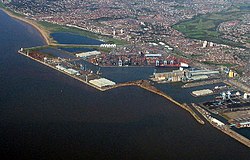
Geography
Montgomery House, Alexander House and Churchill House. In April 2016 Churchill House and Montgomery House were demolished. The demolition of Montgomery House failed causing the area to be evacuated.
Seaforth is between Waterloo in the north, Litherland to the east, Bootle to the south, and the River Mersey and the Port of Liverpool to the west. It is mainly an area of Victorian terraced housing.
This page is based on this Wikipedia article Text is available under the CC BY-SA 4.0 license; additional terms may apply. Images, videos and audio are available under their respective licenses.