
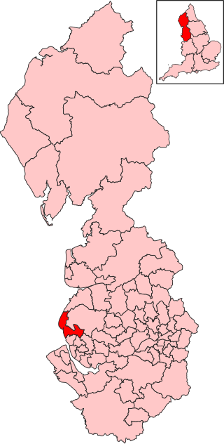
The Metropolitan Borough of Sefton is a metropolitan borough of Merseyside, England. It was formed on 1 April 1974, by the amalgamation of the county boroughs of Bootle and Southport, the municipal borough of Crosby, the urban districts of Formby and Litherland, and part of West Lancashire Rural District. It consists of a coastal strip of land on the Irish Sea which extends from Southport in the north to Bootle in the south, and an inland part to Maghull in the south-east, bounded by the city of Liverpool to the south, the Metropolitan Borough of Knowsley to the south-east, and West Lancashire to the east.

Formby is a town and civil parish in the Metropolitan Borough of Sefton, Merseyside, England.

Crosby is a coastal town in the Metropolitan Borough of Sefton, Merseyside, England. Historically in Lancashire, it is north of Bootle, south of Southport and Formby, and west of Netherton. It abuts the areas of Blundellsands to the north and Waterloo to the south. It is approximately 6 miles (9.6 km) north of Liverpool.

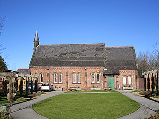
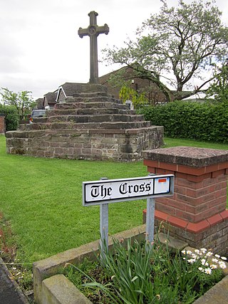
Little Crosby is a small village in the Sefton district of Merseyside, England. Despite being within 8 miles of Liverpool it has retained its rural character by, for example, opting not to have street lights. Until 1974 it was in Lancashire.

Waterloo is a town in the Metropolitan Borough of Sefton, in Merseyside, England. Together with Seaforth, the two setlements make up the borough's Church ward. The area is bordered by Crosby to the north, Seaforth to the south, the Rimrose Valley country park to the east, and to the west Crosby Beach and Crosby Coastal Park.
Ainsdale is a village near Southport, in the Sefton district, in Merseyside, England, situated three miles south of the centre of Southport. Originally in the historic county of Lancashire, at the 2001 Census it had a population of 12,723. By the time of the 2011 census, only figures for Ainsdale (ward) were available.

Little Altcar is a village and civil parish in the Metropolitan Borough of Sefton on Merseyside, within the boundaries of the historic county of Lancashire and on the West Lancashire Coastal Plain of England. The village forms part of the built-up area of Formby. It had a population of 892 in the 2001 Census, increasing to 910 at the 2011 Census.

Hightown is a village and civil parish in the Metropolitan Borough of Sefton in Merseyside, England, located midway between the city of Liverpool and the coastal resort of Southport. It is 8 miles north of Liverpool city centre and is located on the coast near the boundary of the Mersey Estuary and Liverpool Bay. The River Alt joins the sea at this point and forms an estuary. There is a pumping station on the River Alt at Altmouth, built 1972, as part of a programme to alleviate flooding in the area. This is on the Altcar Rifle Range, a Territorial Army base originally established in 1860 by Lt. Col. Gladstone.
Ince Blundell is a village and civil parish in the Metropolitan Borough of Sefton in the ceremonial county of Merseyside and historic county of Lancashire, England. It is situated to the north of Liverpool on the A565 road and to the east of the village of Hightown. There are two associated hamlets of Lady Green and Carr Houses.
Thornton is a village in the Metropolitan Borough of Sefton, in Merseyside, England. Within the boundaries of the historic county of Lancashire and situated to the north east of Crosby, it is a residential area of semi-detached and detached housing which dates mainly from the 1930s. Many of the houses, particularly those around Edge Lane and Water Street, feature notably long gardens. The A565 Liverpool-Southport road serves the area. At the 2001 Census the population of the village and civil parish was recorded as 2,262, falling to 2,139 at the Census 2011.

Crosby was a constituency in Merseyside, represented in the House of Commons of the Parliament of the United Kingdom from 1950 until 2010. It elected one Member of Parliament (MP) by the first past the post system of election.

Knowsley North and Sefton East was a county constituency represented in the House of Commons of the Parliament of the United Kingdom. It elected one Member of Parliament (MP) by the first past the post system of election.
The ceremonial county of Merseyside, created in 1974, is divided into 16 parliamentary constituencies. Three seats cross the county boundary - two are shared with Cheshire and one with Lancashire.

Seaforth is a district in the Metropolitan Borough of Sefton, Merseyside, England. Historically in Lancashire, it is north of Liverpool, between Bootle and Waterloo.
Sefton Central is a constituency represented since its creation in 2010 by Bill Esterson of the Labour Party.

Freshfield railway station serves the Freshfield district of Formby, Merseyside, England. The station is located on the Southport branch of the Merseyrail network's Northern Line.

Sefton Council, or Sefton Metropolitan Borough Council, is the local authority of the Metropolitan Borough of Sefton in Merseyside, England. It is a metropolitan borough council and provides the majority of local government services in the borough. The council has been a member of the Liverpool City Region Combined Authority since 2014.

Brighton-le-Sands is an area of Merseyside, England, in the borough of Sefton. It is located close to Crosby, situated between Blundellsands to the north, Waterloo to the south and Great Crosby to the east.
Thomas Fresh was a pioneer in British environmental health. In 1844, he became Liverpool's first public health officer.

