In 1907, the Victoria County History described Great Crosby's location thus: 'The ancient township of Great Crosby, which includes Waterloo, lies on the northern shore of the estuary of the Mersey, with a level sandy beach extending over three miles (5km) from north-west to southeast; it stretches inland some two miles (3km), and has an area of 2,168 acres (8.77km2), of which 1,907 acres (7.72km2) belong to the present diminished township. The village, which lies more than a mile inland, is becoming modernized and growing quickly, especially along the principal road, that from Liverpool to Southport, which crosses the township in a northerly direction, with roads branching off to the shore and to Thornton. The Liverpool and Southport line of the Lancashire and Yorkshire Railway, opened in 1848, with stations at Waterloo and Blundellsands, also passes through the township. An electric tramway connects Great Crosby with the Seaforth terminus of the Liverpool Overhead Railway.' [1]
History
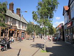
Great Crosby was a small village of Viking origin until the arrival of the railway in the 1840s. The village grew rapidly during the late 19th and early 20th century and merged with a number of distinct areas with their own character, to form the Great Crosby urban district. These areas included:
Thornton, a residential area of semi-detached and detached housing which dates mainly from the 1930s.
Great Crosby was formerly a chapelry in the parish of Sephton,[2] in 1866 Great Crosby became a separate civil parish,[3] in 1894 Great Crosby became an urban district, the urban district annexed Little Crosby in 1932. On 9 November 1937, the district was combined with the Waterloo with Seaforth urban district to form the municipal borough of Crosby,[4] On 1 April 1974 the parish was abolished[5] and it became part of the new Metropolitan Borough of Sefton. In 1951 the parish had a population of 26,982.[6] These boundary changes defined the town of Crosby in its modern borders and shrank down the modern area of Great Crosby from the old urban district, making it an area of the modern town of Crosby which today is a separate area of Crosby to Blundellsands, Brighton-le-Sands, and Thornton.
In the past, Crosby had five cinemas: the Corona, and the Regent were in the northern part of the district. The Corona, almost opposite the Library, in College Road, was part of the Gaumont chain, and after merging with the Rank Organisation became a second-run house, as Rank already had taken over the Plaza in Waterloo, which became an Odeon and had the first run policy. The Corona played the Bill Hayley film 'Rock Around The Clock' just before the cinema closed in 1957 and demolished before the end of that decade. Waterloo had two independent cinemas, the Queens on South Road and the Winter Gardens in Church Road. The Queens closed in the late fifties, and the Winter Gardens closed nearly ten years later.
Another cinema in the Great Crosby area, was the Regent on Liverpool Road at the junction of Endbutt Lane; it became part of the ABC group, and closed in 1967 to become a bingo hall, and has since become part of St. Mary's College. Land had been purchased in Crosby Village, across the road from the Crown Buildings, to be redeveloped into a Super Cinema. This never happened due to the onset of World War II. By the time building restrictions were lifted in the mid-1950s, cinema admissions were in decline. The land remained derelict until the 1960s when the Midland Bank and Satterthwaite's shop, amongst others, were built on the site.
Above the College Road shops, from the Corona Cinema to the corner with Brompton Avenue, was the Corona Ballroom, mostly used for ballroom dancing. The entrance to the ballroom was in Brompton Avenue. Another musical venue was St. Lukes Church Hall on Liverpool Road, where regular Saturday night dances were held.
Alexandra Hall, completed in 1888 and situated at the junction of Mersey Road, College Road and Coronation Road was originally the Town Hall for the Crosby Urban District Council.[7] When the Great Crosby and Waterloo with Seaforth Urban Districts were merged into the Borough of Crosby, the council offices were transferred to Waterloo Town Hall. The frontage of the red brick Alexandra Hall had an ironwork and glass canopy, which was removed in the late 1950s because of rust erosion. Alexandra Hall played host to The Beatles, before they became superstars, in January 1961.[7] The Crosby Flower Show and local drama groups used the Main Hall upstairs each year. In the 1970s the building was converted into Law Courts, and survived to the Millennium. In 2004 the building was demolished and replaced by residential apartments.
A private park, known locally as the 'Key Park', consists of 60 acres (240,000m2) of unspoilt land in Warren Road, Blundellsands. Members pay a subscription, and are given a key.
Set in the Moor Park area, close to the heart of the old village, is the Northern Club, a multi-sporting club.
In College Road is the ground and club house for Marine Football Club. Also worthy of note is Waterloo R.F.C., with their ground in St. Anthony's Road.
The Liverpool Overhead Railway opened in 1893, and to attract more custom, built a street tramway from their terminus at Seaforth Sands railway station, along Crosby Road South, Crosby Road North and Liverpool Road to terminate at the junction of Cooks Road and Victoria Road in the centre of Great Crosby. The tramway started in 1900 and had a 25 years lease; when this was due to expire Liverpool Corporation had shown interest in operating a service into Crosby; talks broke down at a late stage, and the Waterloo and Crosby Motor Services took on the route for bus operation, later taken over by Ribble Motor Services to become the L9.
Before 1932, Ribble Motor Services acquired the small local bus operators, including Waterloo and Crosby Motor Services (Ribble Timetables Area 4 1932). In 1936 Ribble opened a bus station on Little Crosby Road; this was very basic being a plot of land with a turning circle - passengers waited for their bus in a central waiting area which was open to the elements. Buses operated anti-clockwise round the waiting area.
Ribble monopolised the services in the district and their L1, L2, L3, L4, L5, L6, L7, L8, L9, L11, L15, L20, L30, L50, L60, L80, L90, S1, S2 and S3 services served the district. The L3 was Ribble's most frequent service linking Great Crosby with Liverpool Skelhorne Street; the service was also used for trials of new vehicles, and demonstrators. Once a year the S23 operated from Crosby Bus Station to Aintree Old Roan in connection with the Grand National; this service fell into decline and ceased in the early sixties. As traffic congestion grew in the early 1960s, the Ribble services began to suffer reliability problems. Ribble introduced two local services C1 and C2 using single deck vehicles in 1968. In January 1972, Ribble signed an agency agreement with Merseyside Passenger Transport Executive which gave the PTE control of all bus services in Crosby. In November 1974, PTE route 92 was introduced between Hall Road Station and Huyton. The Executive opened the Waterloo Interchange in January 1977, all local bus services were timed to connect with Merseyrail services to and from Liverpool.
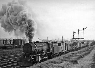
The Liverpool to Southport railway line provided a link to Liverpool Exchange railway station, serving the business sector of the city. The line was listed in Dr. Beeching's Report for closure in 1962, as requiring extra sets of trains for peak hour use only was costly. Merseyside Passenger Transport Executive recognised the needs of the line, and supported improvements to the service and stations, including diverting the line under the city centre (and so closing Liverpool Exchange, replaced by Moorfields railway station) and onward to Hunts Cross, and the line has survived.
The Southport to Liverpool line also had a through service to London Euston on weekdays, when a steam hauled train, generally of two or three carriages, would call at selected stations on the line including Blundellsands & Crosby and Waterloo. The train would leave the line after Bootle Oriel Road, to take the line round the city to join the main line into Lime Street. The through coaches were discontinued in 1966 when the Liverpool Lime Street to London Euston line converted to electric powered locomotives from steam power.
To compensate for this loss of amenity, British Rail introduced a diesel multiple unit service between Southport Chapel Street and Liverpool Lime Street. Generally five trains a day ran on weekdays. This service operated until Liverpool Exchange Station closed in 1977, when the trains from Southport were diverted, proceeding under the city to Liverpool Central Low Level.
Disasters
In 1926 the erosion of the sand dunes near The Serpentine, brought the sides of several large houses down. The River Alt at Formby and Hightown were a major cause to the erosion of the banks of the River Mersey at Crosby. The sea moving ever closer, brought about the total demolition of the residences. Over the years since the erosion, the site has become a promenade for walkers, with a car park with a view.
Merseyside is a ceremonial and metropolitan county in North West England. It borders Lancashire to the north, Greater Manchester to the east, Cheshire to the south, the Welsh county of Flintshire across the Dee Estuary to the southwest, and the Irish Sea to the west. The largest settlement is the city of Liverpool.
The Metropolitan Borough of Sefton is a metropolitan borough of Merseyside, England. It was formed on 1 April 1974, by the amalgamation of the county boroughs of Bootle and Southport, the municipal borough of Crosby, the urban districts of Formby and Litherland, and part of West Lancashire Rural District. It consists of a coastal strip of land on the Irish Sea which extends from Southport in the north to Bootle in the south, and an inland part to Maghull in the south-east, bounded by the city of Liverpool to the south, the Metropolitan Borough of Knowsley to the south-east, and West Lancashire to the east.
Bootle is a town in the Metropolitan Borough of Sefton, Merseyside, England, which had a population of 51,394 in 2011; the wider Parliamentary constituency had a population of 98,449. It is part of the Liverpool City Region.
Litherland is a town in the Metropolitan Borough of Sefton, Merseyside. Until 1899 it was within the historic county of Lancashire. It was an urban district, which included Seaforth and Ford. It neighbours Waterloo to the north, Seaforth to the west, and Bootle to the south and is approximately 5 miles (8.0 km) north of Liverpool city centre.
Formby is a town and civil parish in the Metropolitan Borough of Sefton, Merseyside, England.
Crosby is a coastal town in the Metropolitan Borough of Sefton, Merseyside, England. Historically in Lancashire, it is north of Bootle, south of Southport and Formby, and west of Netherton. It abuts the areas of Blundellsands to the north and Waterloo to the south. It is approximately 6 miles (9.6 km) north of Liverpool.
Waterloo is a town in the Metropolitan Borough of Sefton, in Merseyside, England. Together with Seaforth, the two setlements make up the borough's Church ward. The area is bordered by Crosby to the north, Seaforth to the south, the Rimrose Valley country park to the east, and to the west Crosby Beach and Crosby Coastal Park.
Hightown is a village and civil parish in the Metropolitan Borough of Sefton in Merseyside, England, located midway between the city of Liverpool and the coastal resort of Southport. It is 8 miles north of Liverpool city centre and is located on the coast near the boundary of the Mersey Estuary and Liverpool Bay. The River Alt joins the sea at this point and forms an estuary. There is a pumping station on the River Alt at Altmouth, built 1972, as part of a programme to alleviate flooding in the area. This is on the Altcar Rifle Range, a Territorial Army base originally established in 1860 by Lt. Col. Gladstone.
The Liverpool, Crosby and Southport Railway was a British railway company, which opened a line in 1848 between Southport and Waterloo, extending into Liverpool in 1850. The company was acquired by the Lancashire and Yorkshire Railway in 1855. The line is still open.
Crosby was a constituency in Merseyside, represented in the House of Commons of the Parliament of the United Kingdom from 1950 until 2010. It elected one Member of Parliament (MP) by the first past the post system of election.
Seaforth is a district in the Metropolitan Borough of Sefton, Merseyside, England. Historically in Lancashire, it is north of Liverpool, between Bootle and Waterloo.
Crosby Beach is part of the Merseyside coastline north of Liverpool in the Metropolitan Borough of Sefton, England, stretching about 2.5 miles (4.0 km) North-West from the Seaforth Dock in the Port of Liverpool, through Waterloo, where it separates the sea from the Marina. The beach was awarded Keep Britain Tidy's Quality Coast Award in 2011.
The North Mersey Branch (NMB) is a railway line that was constructed by the Lancashire and Yorkshire Railway to connect its mainline with the northern Mersey dock system.
Bootle New Strand railway station is a railway station in the centre of Bootle, Merseyside, England. It is on the Northern Line of the Merseyrail network and serves in particular the nearby New Strand Shopping Centre. The platforms are elevated and are reached by ramps from the entrance at street level. Connecting bus services leave from the nearby bus station in the basement of New Strand Shopping Centre.
Blundellsands is an area of Crosby in the ceremonial county of Merseyside, England and in the historic county of Lancashire. The area was created as a suburb for wealthy businessmen from Liverpool by the Blundell family of Crosby Hall in the middle of the 19th century.
Blundellsands & Crosby railway station is a railway station in the Blundellsands area of Merseyside, England. It also serves the adjacent town of Crosby. It is situated on the Northern Line of the Merseyrail network.
Ford railway station was a station located on the North Mersey Branch, north Liverpool, Merseyside, England.
Linacre Road railway station was a station located on the North Mersey Branch in Litherland, Lancashire.
Waterloo Town Hall, also known as Crosby Town Hall, is a municipal building in Great George's Road in Waterloo, Merseyside, England. The building, which was the headquarters of Waterloo Urban District Council from 1863 to 1937 and then of Crosby Borough Council from 1937 to 1974, is a Grade II listed building.
This page is based on this Wikipedia article Text is available under the CC BY-SA 4.0 license; additional terms may apply. Images, videos and audio are available under their respective licenses.