Related Research Articles

Ballarat is a city in the Central Highlands of Victoria, Australia. At the 2021 Census, Ballarat had a population of 116,201, making it the third largest city in Victoria.
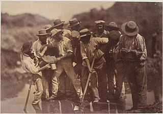
The Victorian gold rush was a period in the history of Victoria, Australia approximately between 1851 and the late 1860s. It led to a period of extreme prosperity for the Australian colony, and an influx of population growth and financial capital for Melbourne, which was dubbed "Marvellous Melbourne" as a result of the procurement of wealth.

The Golden Plains Shire is a local government area in Victoria, Australia, located in the western part of the state. It covers an area of 2,703 square kilometres (1,044 sq mi) and in June 2018, had a population of 23,120. It includes the towns of Bannockburn, Dereel, Gheringhap, Lethbridge, Linton, Berringa, Teesdale, Rokewood and Meredith.

Stawell, is an Australian town in the Wimmera region of Victoria 237 kilometres (147 mi) west-north-west of the state capital, Melbourne. Located within the Shire of Northern Grampians local government area, it is a seat of local government for the shire and its main administrative centre. At the 2021 census, Stawell had a population of 6,220.

Deer Park is a suburb in Melbourne, Victoria, Australia, 17 km (11 mi) west of the Melbourne central business district, located within the City of Brimbank local government area. Deer Park recorded a population of 18,145 at the 2021 census.
Hoddles Creek is a bounded rural locality near Melbourne in Victoria, Australia, located within the Shire of Yarra Ranges local government area. Hoddles Creek recorded a population of 676 at the 2021 census.

Ballarat East is a suburb of Ballarat in Victoria, Australia. From 1857 until 1921 the suburb had its own council. The suburb covers a large area east of the city centre. It is the oldest urban area in Ballarat and was the site of many goldmines, as well as of the Eureka Rebellion.

Berringa is a small township in west-central Victoria, Australia. It is situated in Golden Plains Shire, about 43 km southwest of Ballarat.

Gordon is a small town in Victoria, Australia, named after settler George Gordon. The town is located on the Old Melbourne Road in the Shire of Moorabool local government area, 95 kilometres (59 mi) west of the state capital, Melbourne. At the 2021 census, Gordon had a population of 1,393.

Smythesdale is a town in Victoria, Australia. The town is located on the Glenelg Highway. Most of the town is located in the Golden Plains Shire local government area; however, a small section lies in the Shire of Pyrenees. Smythesdale is 19 kilometres (12 mi) west of Ballarat and 135 kilometres (84 mi) west of the state capital, Melbourne. At the 2016 census, Smythesdale and the surrounding area had a population of 1,032. Smythesdale Primary School is a part of the Woady Yaloak PS with Ross Creek, Scarsdale, and Snake Valley as the other campus'.

Sebastopol is a southern suburb on the rural-urban fringe of Ballarat, Victoria, Australia. It is the third most populated area in urban Ballarat with a population of 10,194 at the 2021 census.

The Ballarat–Skipton Rail Trail in western Victoria, Australia, runs 53 kilometres along the old Skipton railway line from western Ballarat, southwest through Haddon, Smythesdale and Pittong to Skipton. The trail was in poor condition for many years before being upgraded and resurfaced in 2008, at a cost of $700,000, funded in roughly equal measure by local, state and federal government. The new surface is "compacted granitic sand". The total length of the trail is 63km including an 8km section from Ballarat railway station to the trailhead.

The Goldfields region of Victoria is a region commonly used but typically defined in both historical geography and tourism geography. The region is also known as the Victorian Golden Triangle.

Raglan is a town in western Victoria, Australia. It is located 177 kilometres (110 mi) north west of the state capital, Melbourne in the Shire of Pyrenees local government area. At the 2006 census, Raglan and the surrounding area had a population of 456.

Timor (/ˈtaɪˈmɔː/), also known as Timor-Bowenvale, is a mainly rural area in the Central Goldfields Shire of Victoria, Australia. It is located 8 kilometres (5 mi) north of Maryborough, Victoria and 178 kilometres (111 mi) northwest of Melbourne, the state capital.

Mount Pleasant is the oldest residential suburb of Ballarat, Victoria, Australia. It is located on the southern extremity of the city between the Yarrowee Creek and the White Horse Range. Physically it is largely cut off from the rest of Ballarat which contributes to a sense of a suburb apart. The traditional Wathaurung country was first settled in 1836 when the Yuille brothers established a sheep run that included the sheltered corner under the escarpment later named Mount Pleasant. In those days, before there was a town at Ballarat, Buninyong was the nearest township. When the gold rush of 1851 brought thousands of diggers to nearby Golden Point, Mount Pleasant was left alone as no gold was initially found there. Its peacefulness made it attractive to a number of Cornish miners and their families who had come to Australia to settle permanently. These Wesleyans were the founders of the community. As devout and sober church people they sought a place to live away from the drunken mayhem of the diggings around Main Road.

During the Australian gold rushes, starting in 1851, significant numbers of workers moved from elsewhere in Australia and overseas to where gold had been discovered. Gold had been found several times before, but the colonial government of New South Wales had suppressed the news out of the fear that it would reduce the workforce and destabilise the economy.

Snake Valley is a town in central Western Victoria, Australia, on Linton-Carngham Road, 27 kilometres (17 mi) west of Ballarat and 153 kilometres (95 mi) west of Melbourne, in the Shire of Pyrenees. A post office was opened on 1 March 1859. At the 2016 Census, Snake Valley had a population of 743, up from 329 in 2006.

Canoona is a rural locality in the Livingstone Shire, Queensland, Australia. In the 2016 census, Canoona had a population of 81 people. It was the site of the first North Australian gold rush.

Bald Hills is a locality in central Victoria, Australia, in the Hepburn Shire local government area, 107 kilometres (66 mi) west of the state capital, Melbourne, and 14 kilometres (8.7 mi) north of Ballarat. The area is about 442 metres (1,450 ft) above sea level.
References
Localities in the Golden Plains Shire | ||
|---|---|---|
| Town |  | |
| Locality |
| |
^ - Territory divided with another LGA | ||
| | This article about a location in Grampians (region) is a stub. You can help Wikipedia by expanding it. |