The North Pole, also known as the Geographic North Pole, Terrestrial North Pole or 90th Parallel North, is the point in the Northern Hemisphere where the Earth's axis of rotation meets its surface. It is called the True North Pole to distinguish from the Magnetic North Pole.

Svalbard, previously known as Spitsbergen or Spitzbergen, is a Norwegian archipelago in the Arctic Ocean. North of mainland Europe, it lies about midway between the northern coast of Norway and the North Pole. The islands of the group range from 74° to 81° north latitude, and from 10° to 35° east longitude. The largest island is Spitsbergen, followed in size by Nordaustlandet and Edgeøya. The largest settlement is Longyearbyen on the west coast of Spitsbergen.

Ellesmere Island is Canada's northernmost and third largest island, and the tenth largest in the world. It comprises an area of 196,236 km2 (75,767 sq mi), slightly smaller than Great Britain, and the total length of the island is 830 km (520 mi).

Bear Island is the southernmost island of the Norwegian Svalbard archipelago. The island is located at the limits of the Norwegian and Barents seas, approximately halfway between Spitsbergen and the North Cape. Bear Island was discovered by Dutch explorers Willem Barentsz and Jacob van Heemskerck on 10 June 1596. It was named after a polar bear that was seen swimming nearby. The island was considered terra nullius until the Spitsbergen Treaty of 1920 placed it under Norwegian sovereignty.
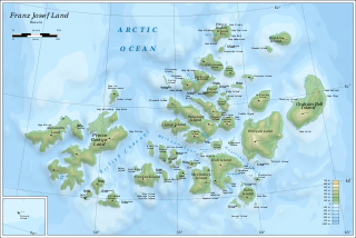
Franz Josef Land is a Russian archipelago in the Arctic Ocean. It is inhabited only by military personnel. It constitutes the northernmost part of Arkhangelsk Oblast and consists of 192 islands, which cover an area of 16,134 square kilometers (6,229 sq mi), stretching 375 kilometers (233 mi) from east to west and 234 kilometers (145 mi) from north to south. The islands are categorized in three groups separated by the British Channel and the Austrian Strait. The central group is further divided into a northern and southern section by the Markham Sound. The largest island is Prince George Land, which measures 2,741 square kilometers (1,058 sq mi), followed by Wilczek Land, Graham Bell Island and Alexandra Land.
The extreme points of Norway include the coordinates that are farther north, south, east or west than any other location in Norway; and the highest and the lowest altitudes in the country. The northernmost point is Rossøya on Svalbard, the southernmost is Pysen in Lindesnes Municipality, the easternmost is Kræmerpynten on Svalbard, and the westernmost is Hoybergodden on Jan Mayen. The highest peak is Galdhøpiggen, standing at 2,469 m (8,100 ft) above mean sea level, while the lowest elevation is sea level at the coast.
Nordvest-Spitsbergen National Park is located on the Norwegian arctic archipelago of Svalbard and includes parts of north-west Spitsbergen and nearby islands such as Danes Island and Moffen. It contains, among other things, warm springs and remains of volcanoes in Bockfjorden.

Camp Barneo is a private temporary tourist resort located on Arctic Ocean ice near the North Pole. When it is occupied for a few weeks in April, it is the northernmost inhabited place in the world. It was first established in 2002 and re-occupied annually thereafter, but it has remained vacant since 2018. When operating, the price for a visit starts at about $20,000.

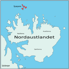
Sjuøyane is the northernmost part of the Svalbard archipelago north of mainland Norway, and some 20 km north of the eastern major island Nordaustlandet. The islands are the northernmost landmass reachable by normal means, being 1024.3 kilometers south of the North Pole. In comparison, Robert Falcon Scott started his ill-fated Terra Nova Expedition 1374 km from the South Pole. Many of the islands are named after English explorers, most notably Captain Nelson.

Phippsøya is the largest island in Sjuøyane, an archipelago north of Nordaustlandet, Svalbard in Arctic Norway. It is located some 22 km north of Nordkapp on Svalbard proper and 8.5 km south of Rossøya, the northernmost island of the Svalbard archipelago. Phippsøya is separated from Parryøya to the south by the 1.3 km wide Straumporten sound, from Martensøya to the southeast by the 1.1 km wide Trollsundet and from Tavleøya to the northwest by the 1 km wide Marmorsundet.
Vesle Tavleøya is the larger island of the two northernmost of Sjuøyane - the other being Rossøya, north of Nordaustlandet, Svalbard. Vesle Tavleøya is situated some 7 km northeast of Phippsøya, the largest island of the islands, separated by Sjuøyflaket sound.
Parryøya is southernmost of the three larger islands in Sjuøyane, situated 15 km northeast of Nordaustlandet, Svalbard. Parryøya is separated from Phippsøya to the north by the 1.3 km wide Straumporten sound and from Chermsideøya to the south by Nordkappsundet. Some five or more skerries south of the island's southern tip Fòreneset are named Fòrenesholmane, and two skerries east of the island are named Skrikholmane. The islands total area ca. 20 km2.. Highest point Øykollen ca. 400 m.a.s.l.. Area covered with ice: ca. 3%, approximately 0,6 km2..

Farthest North describes the most northerly latitude reached by explorers, before the first successful expedition to the North Pole rendered the expression obsolete. The Arctic polar regions are much more accessible than those of the Antarctic, as continental land masses extend to high latitudes and sea voyages to the regions are relatively short.

Nordaust-Svalbard Nature Reserve is located in the north-eastern part of the Svalbard archipelago in Norway. The nature reserve covers all of Nordaustlandet, Kong Karls Land, Kvitøya, Sjuøyane, Storøya, Lågøya, Wilhelm Island, Wahlbergøya and a small section of the north-east corner of Spitsbergen. The reserve is 55,354 square kilometres (21,372 sq mi), of which 18,663 square kilometres (7,206 sq mi) is on land and 36,691 square kilometres (14,166 sq mi) is on water—making it the largest preserved area in Norway. It includes the largest glacier in Norway, Austfonna, as well as Vestfonna and parts of Olav V Land. The reserve has been protected since 1 July 1973 and borders in the south to Søraust-Svalbard Nature Reserve.
Chermsideøya is a 14 km² island north of Nordaustlandet, Svalbard. It is separated from Nordaustlandet by the 1–2 km wide Beverlysundet. Two km to the east lies the two smaller Castrénøyane.
Nordkappsundet is a 10-15 km wide strait between Chermsideøya off the north of Nordaustlandet in the south and Sjuøyane in the north, Svalbard in Arctic Norway. Named after Nordkapp on Chermsideøya, the northern extreme of mainland Svalbard.
Straumporten is a 1,340 m (4,400 ft)-wide sound between the southernmost part, Migmatittodden of Phippsøya and northeast side, Gullberget of Parryøya, in Sjuøyane north of Nordaustlandet in Svalbard, Norway.
Migmatittodden is the southern headland of Phippsøya, one of Sjuøyane, north of Nordaustlandet, Svalbard, Norway.
Franz Josef Land, an uninhabited archipelago located in the Arctic Ocean, Barents Sea, and Kara Sea, may have been discovered by the 1865 expedition of the Norwegian sealing vessel Spidsbergen captained by Nils Fredrik Rønnbeck. However, the discovery was never announced and the existence of the territory only came to public notice following the Austro-Hungarian North Pole Expedition of 1872, which named the archipelago in honor of Franz Joseph I of Austria. Benjamin Leigh Smith led the next expedition in 1880, which continued the work of the first expeditions in investigating the southern and central parts of the archipelago. Concurrent expeditions followed in 1896, Nansen's Fram expedition and the Jackson–Harmsworth Expedition, which met by accident. These two journeys explored the northern area and the flanks of Franz Josef Land.