
The Rotondo Granite is a late Variscan granitic intrusion located in the Saint-Gotthard Massif in the Swiss Alps. Its name comes from the Pizzo Rotondo.
The Rotondo Granite is a late Variscan granitic intrusion located in the Saint-Gotthard Massif in the Swiss Alps. Its name comes from the Pizzo Rotondo.
It shows as a fine to medium-grained granite. Unlike other granitic intrusions present in the Gotthard Massif (Gamsboden Granite and Fibbia Granite), the foliation is only very weakly developed [1] and is mostly visible in ductile shear zones. Radiometric dating showed an age of 294 Ma. [2] On surface, it outcrops over an area of 20–25 km2. [3]
The Rotondo Granite forms at least part of Monte Prosa. [4]

The Bedretto Underground Laboratory for Geoenergies which is located in the Bedretto Tunnel (in German "Bedretto-Fenster"), is performing research on deep geothermal energy in the Rotondo Granite. The underground laboratory is operated by the Swiss Federal Institute of Technology in Zürich (ETH Zurich). The site was selected, among other reasons, because of the similarities that this rock shows with basement rocks that are expected to be encountered at a depth of 4–5 km below the Swiss Plateau.

Switzerland has a dense network of roads and railways. The Swiss public transport network has a total length of 24,500 kilometers and has more than 2600 stations and stops.

The Alpine region of Switzerland, conventionally referred to as the Swiss Alps, represents a major natural feature of the country and is, along with the Swiss Plateau and the Swiss portion of the Jura Mountains, one of its three main physiographic regions. The Swiss Alps extend over both the Western Alps and the Eastern Alps, encompassing an area sometimes called Central Alps. While the northern ranges from the Bernese Alps to the Appenzell Alps are entirely in Switzerland, the southern ranges from the Mont Blanc massif to the Bernina massif are shared with other countries such as France, Italy, Austria and Liechtenstein.
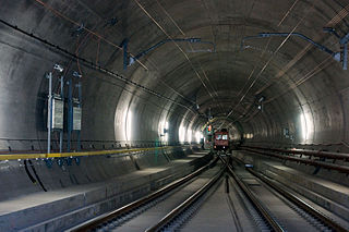
The Gotthard Base Tunnel is a railway tunnel through the Alps in Switzerland. It opened in June 2016 and full service began the following December. With a route length of 57.09 km (35.5 mi), it is the world's longest railway and deepest traffic tunnel and the first flat, low-level route through the Alps. It lies at the heart of the Gotthard axis and constitutes the third tunnel connecting the cantons of Uri and Ticino, after the Gotthard Tunnel and the Gotthard Road Tunnel.

The Gotthard Road Tunnel in Switzerland runs from Göschenen in the canton of Uri at its northern portal, to Airolo in Ticino to the south, and is 16.9 kilometres (10.5 mi) in length below the St Gotthard Pass, a major pass of the Alps. At time of construction, in 1980, it was the longest road tunnel in the world; it is currently the fifth-longest. Although it is a motorway tunnel, part of the A2 from Basel to Chiasso, it consists of only one bidirectional tube with two lanes. With a maximum elevation of 1,175 metres (3,855 ft) at the tunnel's highest point, the A2 motorway has the lowest maximum elevation of any direct north-south road through the Alps.

Airolo is a municipality in the district of Leventina in the canton of Ticino in Switzerland.
The New Railway Link through the Alps, is a Swiss construction project for faster north–south rail links across the Swiss Alps. It consists of two axes with several improvements along these rails including three new base tunnels several hundred metres below the existing apex tunnels, the 57-kilometre (35 mi) Gotthard Base Tunnel, the 35-kilometre (22 mi) Lötschberg Base Tunnel, and the 15-kilometre (9.3 mi) Ceneri Base Tunnel. Swiss Federal Railways subsidiary AlpTransit Gotthard AG and BLS AG subsidiary BLS Alp Transit AG were founded for this project and built the tunnels.

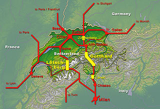
The Gotthard Pass or St. Gotthard Pass at 2,106 m (6,909 ft) is a mountain pass in the Alps traversing the Saint-Gotthard Massif and connecting northern Switzerland with southern Switzerland. The pass lies between Airolo in the Italian-speaking canton of Ticino, and Andermatt in the German-speaking canton of Uri, and connects further Bellinzona and Lugano to Lucerne, Basel, and Zurich. The Gotthard Pass lies at the heart of the Gotthard, a major transport axis of Europe, and it is crossed by three traffic tunnels, each being the world's longest at the time of their construction: the Gotthard Rail Tunnel (1882), the Gotthard Road Tunnel (1980) and the Gotthard Base Tunnel (2016). With the Lötschberg to the west, the Gotthard is one of the two main north-south routes through the Swiss Alps.

The Furka Base Tunnel is a Swiss railway base tunnel on the Matterhorn Gotthard Bahn's Furka–Oberalp line, an east-west railway connecting the cantons of Valais and Uri. Its west portal lies east of Oberwald (VS), at 1,390 m (4,560 ft) above sea level and its east portal lies south of Realp (UR), at 1,550 m (5,090 ft).

The Gotthard Tunnel is a 15-kilometre-long (9.3 mi) railway tunnel that forms the summit of the Gotthard Railway in Switzerland. It connects Göschenen with Airolo and was the first tunnel through the Saint-Gotthard Massif in order to bypass the St Gotthard Pass. It was built as single bore tunnel accommodating a standard gauge double-track railway throughout. When opened in 1882, the Gotthard Tunnel was the longest tunnel in the world.

The Aarmassif or Aaremassif is a geologic massif in the Swiss Alps. It contains a number of large mountain chains and parts of mountain chains.
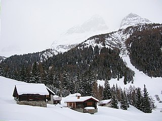
Bedretto is a municipality and a village in the Val Bedretto, the upper most part of the river Ticino. It belongs to the district of Leventina in the canton of Ticino in Switzerland.
The Zimmerberg Base Tunnel (ZBT) is a railway tunnel under the Zimmerberg mountains in Switzerland. Phase I of the tunnel was opened to traffic during April 2003.

Pizzo Rotondo is a mountain in the Lepontine Alps. At 3,190 metres above sea level, it is the highest mountain lying on the border between the cantons of Ticino and Valais, as well as the highest summit of the Lepontine Alps lying between Nufenen Pass and Lukmanier Pass.

Lucerne railway station is a major hub of the rail network of Switzerland, in the city of Lucerne in the canton of Lucerne. It is a terminal station serving domestic and international traffic on several rail lines, and is situated in a city centre and waterfront location on the south side of Lake Lucerne.
The Gotthard nappe is, in the geology of the Alps a nappe in the Helvetic zone of Switzerland. It consists of crystalline rocks that were, before the formation of the Alps, part of the upper crust of the southern margin of the European continent. As it names suggests, the Gotthard nappe lies in close proximity to the Gotthard Massif.
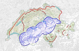
The Gotthard Massif or Saint-Gotthard Massif is a mountain range in the Alps in Switzerland, located at the border of four cantons: Valais, Ticino, Uri and Graubünden. It is delimited by the Nufenen Pass on the west, by the Furka Pass and the Oberalp Pass on the north and by the Lukmanier Pass on the east. The eponymous Gotthard Pass, lying at the heart of the massif, is the main route from north to south.
The Swiss National Redoubt is a defensive plan developed by the Swiss government beginning in the 1880s to respond to foreign invasion. In the opening years of the Second World War the plan was expanded and refined to deal with a potential German invasion. The term "National Redoubt" primarily refers to the fortifications begun in the 1880s that secured the mountainous central part of Switzerland, providing a defended refuge for a retreating Swiss Army.

Mont Terri is one of the mountains of the Jura Mountains range. It is located south of Cornol in the Canton of Jura. The mountain can be located 140 km west of Zurich.

High-speed rail in Switzerland consists of two new lines and three new base tunnels, including the world's longest railway and deepest traffic tunnel: the Gotthard Base Tunnel whose length is 57 km (35 mi). Each of these tunnels have a technical maximum speed of 250 km/h (155 mph), which is reduced, at least in the Gotthard Base Tunnel and the Ceneri Base Tunnel to a maximal authorized speed of 230 km/h (143 mph) for ecological and economical reasons, while the normal operational speed of passenger trains is restricted to 200 km/h (124 mph) in order to accommodate the freight traffic, with the possibility to accelerate up to 230 km/h (143 mph) in case of delay.
Monte Prosa is a mountain in the Saint-Gotthard Massif, a mountain range in the Lepontine Alps of Switzerland.