Rotundu

Last updated

Rotundu is a flat, heavily forested peak on the side of Mount Kenya. It's formed by a near-perpendicular wall raising from a height of approximately 3,100 metres (10,200 ft) [1] above sea level and finally flattening 150 metres (490 ft) above the peak's base. The flat land on the peak also hosts Lake Rotundu ( 0°02′28″S37°27′48″E / 0.041242°S 37.463458°E / -0.041242; 37.463458 . Some of the plants found on the peak are puzzling, as one would not expect to find them growing at that altitude.[ citation needed ]

Summit A point on a surface that is higher in elevation than all points immediately adjacent to it, in topography

A summit is a point on a surface that is higher in elevation than all points immediately adjacent to it. Mathematically, a summit is a local maximum in elevation. The topographic terms acme, apex, peak, and zenith are synonymous.

Mount Kenya mountain range

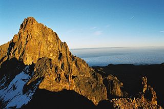
Mount Kenya is the highest mountain in Kenya and the second-highest in Africa, after Kilimanjaro. The highest peaks of the mountain are Batian, Nelion and Point Lenana. Mount Kenya is located in the former Eastern and central provinces of Kenya, now Meru, Embu, Laikipia, Kirinyaga, Nyeri and Isiolo counties, about 16.5 kilometres (10.3 mi) south of the equator, around 150 kilometres (93 mi) north-northeast of the capital Nairobi. Mount Kenya is the source of the name of the Republic of Kenya.

Sea level Average level for the surface of the ocean at any given geographical position on the planetary surface

Mean sea level (MSL) is an average level of the surface of one or more of Earth's oceans from which heights such as elevation may be measured. MSL is a type of vertical datum – a standardised geodetic datum – that is used, for example, as a chart datum in cartography and marine navigation, or, in aviation, as the standard sea level at which atmospheric pressure is measured to calibrate altitude and, consequently, aircraft flight levels. A common and relatively straightforward mean sea-level standard is the midpoint between a mean low and mean high tide at a particular location.

Related Research Articles

Mount Elgon mountain

Mount Elgon is an extinct shield volcano on the border of Uganda and Kenya, north of Kisumu and west of Kitale. The mountain's highest point, named "Wagagai", is located entirely within Uganda. Although there is no verifiable evidence of its earliest volcanic activity, geologists estimate that Mount Elgon is at least 24 million years old, making it the oldest extinct volcano in East Africa.

Nyenchen Tanglha Mountains mountain range

The Nyenchen Tanglha Mountains are a 700-kilometre (430 mi) long mountain range, and subrange of the Transhimalaya System, located in the Tibet region and the Tibet Autonomous Region of China.

Amboseli Airport

Amboseli Airport is an airport in Kenya.

Nanyuki Airport

Nanyuki Airfield is an airport in Nanyuki, Kenya.

Samburu Airport

Samburu Airport is an airport in Samburu County, Kenya.

Lokichogio Airport airport in Lokichogio, Kenya

Lokichogio Airport is an airport in Lokichogio, Kenya.

Cnoc na Péiste Mountain in Kerry, Ireland

Cnoc na Péiste, anglicised Knocknapeasta, at 988 metres (3,241 ft), is the fourth-highest peak in Ireland, on the Arderin and Vandeleur-Lynam scales. Cnoc na Péiste is one of only two 3,000 ft peaks in the Reeks with a prominence above the Marilyn threshold of 150 metres, and is the highest summit of the Eastern Reeks. In 1943, a USAAF plane crashed into the mountain, killing all five crew, and parts of the wreckage can still be seen in Lough Cummeenapeasta. Cnoc na Péiste is part of the MacGillycuddy's Reeks range in County Kerry.

Mountaineering on Mount Kenya

Most of the peaks on Mount Kenya have been summited. The majority of these involve rock climbing as the easiest route, although some only require a scramble or a walk. The highest peak that can be ascended without climbing is Point Lenana, 4,985 metres (16,355 ft). The majority of the 15,000 visitors to the national park each year climb this peak. In contrast, approximately 200 people summit Nelion and 50 summit Batian, the two highest peaks.

Birkholm island in Denmark

Birkholm is a small Danish island off the southern coast of Funen in Ærø Municipality. With an area of just 0.9 km2 (0.3 sq mi), as of 1 January 2010 it has a population of 10. The flat, low-lying island is just over 2 km (1 mi) long and 2 metres above sea level at its highest point, though the protective dykes are 2.8 metres high. It can be reached by post boat from Marstal on Ærø in 25 minutes.

Ashburton River / Hakatere river in New Zealand

The Ashburton River / Hakatere is a river in the Canterbury Region of New Zealand, flowing across Mid Canterbury from the Southern Alps to the Pacific Ocean. The official name of the river was amended to become a dual name by the Ngai Tahu Claims Settlement Act 1998. It has been identified as an Important Bird Area by BirdLife International because it supports breeding colonies of the endangered black-billed gull.

Ruhengeri Airport

Ruhengeri Airport is an airport in Rwanda.

Busia Airport

Busia Airport is an airport in Kenya.

Mtito Andei Airport

Mtito Andei Airport is an airport in Kenya.

Embu Airport

Embu Airport is an airport in Kenya.

Isiolo Airport

Isiolo Airport, also Isiolo International Airport is an airport located in Isiolo, Isiolo County, and Meru County, Kenya.

Lingtren Himalayan mountain

Lingtren, 6,749 metres (22,142 ft), is a mountain in the Mahalangur Himal area of Himalaya, about 8 kilometres (5.0 mi) distant in a direct line from Mount Everest. It lies on the international border between Nepal and the Tibet Autonomous Region of China and it was first climbed in 1935. A mountain nearby to the west was originally named Lingtrennup but is now more commonly called Xi Lingchain.

References

  1. Mt Kenya 1:50000 Map and Guide (Map) (1 ed.). 1:50000 with 1:25000 inset. Cartography by West Col Productions. Andrew Wielochowski and Mark Savage. 1991. ISBN   0-906227-39-9.

Coordinates: 0°02′05″S37°27′55″E / 0.034729°S 37.465244°E / -0.034729; 37.465244

Geographic coordinate system Coordinate system

A geographic coordinate system is a coordinate system that enables every location on Earth to be specified by a set of numbers, letters or symbols. The coordinates are often chosen such that one of the numbers represents a vertical position and two or three of the numbers represent a horizontal position; alternatively, a geographic position may be expressed in a combined three-dimensional Cartesian vector. A common choice of coordinates is latitude, longitude and elevation. To specify a location on a plane requires a map projection.