Related Research Articles

The Gall–Peters projection is a rectangular, equal-area map projection. Like all equal-area projections, it distorts most shapes. It is a cylindrical equal-area projection with latitudes 45° north and south as the regions on the map that have no distortion. The projection is named after James Gall and Arno Peters.

In cartography, a map projection is any of a broad set of transformations employed to represent the curved two-dimensional surface of a globe on a plane. In a map projection, coordinates, often expressed as latitude and longitude, of locations from the surface of the globe are transformed to coordinates on a plane. Projection is a necessary step in creating a two-dimensional map and is one of the essential elements of cartography.

In mathematics, a stereographic projection is a perspective projection of the sphere, through a specific point on the sphere, onto a plane perpendicular to the diameter through the point. It is a smooth, bijective function from the entire sphere except the center of projection to the entire plane. It maps circles on the sphere to circles or lines on the plane, and is conformal, meaning that it preserves angles at which curves meet and thus locally approximately preserves shapes. It is neither isometric nor equiareal.

Orthographic projection is a means of representing three-dimensional objects in two dimensions. Orthographic projection is a form of parallel projection in which all the projection lines are orthogonal to the projection plane, resulting in every plane of the scene appearing in affine transformation on the viewing surface. The obverse of an orthographic projection is an oblique projection, which is a parallel projection in which the projection lines are not orthogonal to the projection plane.

Orthographic projection in cartography has been used since antiquity. Like the stereographic projection and gnomonic projection, orthographic projection is a perspective projection in which the sphere is projected onto a tangent plane or secant plane. The point of perspective for the orthographic projection is at infinite distance. It depicts a hemisphere of the globe as it appears from outer space, where the horizon is a great circle. The shapes and areas are distorted, particularly near the edges.

The oblique Mercator map projection is an adaptation of the standard Mercator projection. The oblique version is sometimes used in national mapping systems. When paired with a suitable geodetic datum, the oblique Mercator delivers high accuracy in zones less than a few degrees in arbitrary directional extent.

The universal polar stereographic (UPS) coordinate system is used in conjunction with the universal transverse Mercator (UTM) coordinate system to locate positions on the surface of the Earth. Like the UTM coordinate system, the UPS coordinate system uses a metric-based cartesian grid laid out on a conformally projected surface. UPS covers the Earth's polar regions, specifically the areas north of 84°N and south of 80°S, which are not covered by the UTM grids, plus an additional 30 minutes of latitude extending into UTM grid to provide some overlap between the two systems.
In mathematics, a projection is an idempotent mapping of a set into a subset. In this case, idempotent means that projecting twice is the same as projecting once. The restriction to a subspace of a projection is also called a projection, even if the idempotence property is lost. An everyday example of a projection is the casting of shadows onto a plane : the projection of a point is its shadow on the sheet of paper, and the projection (shadow) of a point on the sheet of paper is that point itself (idempotency). The shadow of a three-dimensional sphere is a closed disk. Originally, the notion of projection was introduced in Euclidean geometry to denote the projection of the three-dimensional Euclidean space onto a plane in it, like the shadow example. The two main projections of this kind are:

The Planisphaerium is a work by Ptolemy. The title can be translated as "celestial plane" or "star chart". In this work Ptolemy explored the mathematics of mapping figures inscribed in the celestial sphere onto a plane by what is now known as stereographic projection. This method of projection preserves the properties of circles.
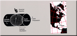
Space-oblique Mercator projection is a map projection devised in the 1970s for preparing maps from Earth-survey satellite data. It is a generalization of the oblique Mercator projection that incorporates the time evolution of a given satellite ground track to optimize its representation on the map. The oblique Mercator projection, on the other hand, optimizes for a given geodesic.

John Parr Snyder was an American cartographer most known for his work on map projections for the United States Geological Survey (USGS). Educated at Purdue and MIT as a chemical engineer, he had a lifetime interest in map projections as a hobby, but found the calculations tedious without the benefit of expensive calculators or computers. At a cartography conference in 1976, he learned of the need for a map projection that would suit the special needs of Landsat satellite imagery. He had recently been able to purchase a pocket calculator (TI-59) of his own and set to work creating what became known as the space-oblique mercator projection, which he provided to the USGS at no charge. Library of Congress historian John Hessler stated it is "perhaps the most complex map projection".

The Peirce quincuncial projection is the conformal map projection from the sphere to an unfolded square dihedron, developed by Charles Sanders Peirce in 1879. Each octant projects onto an isosceles right triangle, and these are arranged into a square. The name quincuncial refers to this arrangement: the north pole at the center and quarters of the south pole in the corners form a quincunx pattern like the pips on the five face of a traditional die. The projection has the distinctive property that it forms a seamless square tiling of the plane, conformal except at four singular points along the equator.
GS50, also hyphenated as GS-50, is a map projection that was developed by John Parr Snyder of the USGS in 1982.
The General Perspective projection is a map projection. When the Earth is photographed from space, the camera records the view as a perspective projection. When the camera is aimed toward the center of the Earth, the resulting projection is called Vertical Perspective. When aimed in other directions, the resulting projection is called a Tilted Perspective.

The Guyou hemisphere-in-a-square projection is a conformal map projection for the hemisphere. It is an oblique aspect of the Peirce quincuncial projection.
In cartography, a conformal map projection is one in which every angle between two curves that cross each other on Earth is preserved in the image of the projection; that is, the projection is a conformal map in the mathematical sense. For example, if two roads cross each other at a 39° angle, their images on a map with a conformal projection cross at a 39° angle.

The Gall stereographic projection, presented by James Gall in 1855, is a cylindrical projection. It is neither equal-area nor conformal but instead tries to balance the distortion inherent in any projection.
Osborn Maitland Miller (1897–1979) was a Scottish-American cartographer, surveyor and aerial photographer. A member of several expeditions himself, he also acted as adviser to other explorers. He developed several map projections, including the Bipolar Oblique Conic Conformal, the Miller Oblated Stereographic, and most notably the Miller Cylindrical in 1942.

The stereographic projection, also known as the planisphere projection or the azimuthal conformal projection, is a conformal map projection whose use dates back to antiquity. Like the orthographic projection and gnomonic projection, the stereographic projection is an azimuthal projection, and when on a sphere, also a perspective projection.
References
- ↑ Snyder, John P. (1993). Flattening the Earth: Two Thousand Years of Map Projections p. 169. Chicago and London: The University of Chicago Press. ISBN 0-226-76746-9.