Paraguay's transportation system ranges from adequate to poor, largely depending on the region of the country. The country has a network of roads, railroads, rivers, and airports, but significant infrastructure and regulation improvements are needed.

Central is a department in Paraguay. The capital is Areguá. With 2,243,792 inhabitants, it is the most populated and the smallest of the 17 departments of Paraguay.

Cordillera is a department in Paraguay. The capital is the city of Caacupé.

Ruta Nacional 3 is an Argentine highway, stretching from the eastern side of the country in Buenos Aires, crossing the provinces of Buenos Aires, Río Negro, Chubut Province, Santa Cruz and Tierra del Fuego. Since its start at Avenida General Paz (A001) until the end, on the bridge over Lapataia River, it measures 3,045 kilometres (1,892 mi).
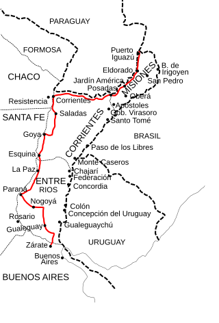
National Route 12 (RN12) is a road in Argentina, connecting the northeast section to the rest of the country. It runs through the provinces of Misiones, Corrientes, Entre Ríos and Buenos Aires.

National Route 117 is a national road in Argentina, in Paso de los Libres Department in the SE of Corrientes Province. From its start in km marker 496 of National Route 14 until its end at the Paso de los Libres-Uruguaiana International Bridge unites the cities of Paso de los Libres, Argentina and Uruguaiana, Brazil for a total length of 12.9 kilometres (8 mi). The road is marked in red in the map.
National Route A005 is an 11 km (6.8 mi)-long two-lane highway connecting National Route 8 and National Route 36 in the city of Río Cuarto, Córdoba Province, Argentina.
Federal Highway 190 is a Federal Highway of Mexico. Federal Highway 190 is split into two segments: the first segment travels from Tehuantepec, Oaxaca in the east to Puebla City, Puebla in the west. The second segment travels from La Ventosa, Juchitán de Zaragoza Municipality, Oaxaca in the west eastward to Ciudad Cuauhtémoc, Chiapas. Fed. Highway 190's eastern segment ends at a Guatemala-Mexico border crossing at Ciudad Cuauhtémoc. The Pan-American Highway route in southern Mexico continues into Guatemala as Central American Highway 1 (CA-1).
Félix Pérez Cardozo is a town and district located in the Guairá Department of Paraguay. It is located approximately 186 km (116 mi) from the national capital Asunción. In this town, its inhabitants are dedicated to the cultivation of sugar cane and tobacco, as well as crafts, especially Ao po'i embroidery.
Route 6 is a National Road in the South American Andean state of Bolivia.

National Road Network of Costa Rica, are a series of numbered road routes that are managed through Costa Rica by the Ministry of Public Works and Transport (MOPT) and its subagency the National Road Council (Conavi).

National Route 20 is a highway in Paraguay, which runs from San Patricio to Paso de Patria, connecting the southern cities of the departments of Misiones and Ñeembucú. It's currently paved only from San Patricio to Yabebyry.

National Route 18 is a highway in Paraguay, which runs from northern Itapúa to Central, crossing also the departments of Caazapá, Guairá and Paraguarí.

National Route 22 is a highway in Paraguay, which connects two northern departments of Paraguay, San Pedro and Concepción.

National Route 12 is a highway in Paraguay, which runs from Chaco'i, part of the district of Villa Hayes, to Pozo Hondo, part of the district of Dr. Pedro P. Peña, connecting the western Chaco region to the metropolitan area of Asunción. It's currently paved only from Chaco'i to Tinfunqué National Park.

National Route 13 is a highway in Paraguay, which runs from Paso Yobai to Ypehú, connecting the departments of Guairá, Caaguazú and Canindeyú.

National Route 15 also known as Corredor Bioceánico is one of 22 national routes of Paraguay.
It has an extension of 531 km, in the middle of the Paraguayan Chaco. Along with routes PY14 and PY16, it is one of the three routes that the Alto Paraguay department will possess for the first time, helping it to come out of isolation. At the beginning of the section of this route, the international bridge that will connect Carmelo Peralta with Porto Murtinho (Brazil) is under construction, which will be financed by Itaipu.
This highway is expected to become an international logistics center by becoming part of the Bi-Oceanic Corridor, and being the shortest passage between the Chilean ports of Antofagasta and Iquique on the Pacific Ocean and the Brazilian port of Santos on the Atlantic Ocean.

National Route 11 (RN11), known officially as Carretera Juan de Garay, is a road in Argentina, which runs through the provinces of Santa Fe, Chaco, and Formosa. From its beginning in the Rosario Beltway until it ends at the San Ignacio de Loyola International Bridge, on the border with Paraguay, it covers 980 km (610 mi), fully paved. In Formosa Province, the 80 km (50 mi) highway is under construction between the intersection with National Route 81 to the north of the City of Formosa and the town of General Lucio V. Mansilla on the shores of the Bermejo River bordering the Chaco Province.
National Route 17 is a highway in Paraguay, which runs from Salto del Guairá to Pedro Juan Caballero, both on the border with Brazil. It has an extension of 380 km (240 mi), in the northeast of the Eastern Region. The entire route is adjacent to the Maracayú and Amambai Mountains.


