Paraguay, officially the Republic of Paraguay, is a landlocked country in South America. It is bordered by Argentina to the south and southwest, Brazil to the east and northeast, and Bolivia to the northwest. It has a population of around 7.4 million, nearly 3 million of whom live in the capital and largest city of Asunción, and its surrounding metro area.
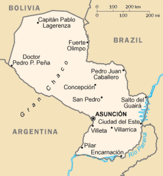
Paraguay is a country in South America, bordering Brazil, Argentina and Bolivia. The Paraguay River divides the country into strikingly different eastern and western regions. Both the eastern region and the western region gently slope toward and are drained into the Paraguay River, which separates and unifies the two regions. With the Paraneña region reaching southward and the Chaco extending to the north, Paraguay straddles the Tropic of Capricorn and experiences both subtropical and tropical climates.
Paraguay's transportation system ranges from adequate to poor, largely depending on the region of the country. The country has a network of roads, railroads, rivers, and airports, but significant infrastructure and regulation improvements are needed.
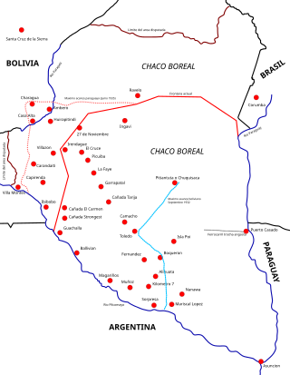
The Chaco War was fought from 1932 to 1935 between Bolivia and Paraguay, over the control of the northern part of the Gran Chaco region of South America, which was thought to be rich in oil. The war is also referred to as La Guerra de la Sed in literary circles since it was fought in the semi-arid Chaco. The bloodiest interstate military conflict fought in South America in the 20th century, it was fought between two of its poorest countries, both of which had lost territory to neighbours in 19th-century wars.

Asunción is the capital and the largest city of Paraguay.

Tarija is a department in Bolivia. It is located in south-eastern Bolivia bordering with Argentina to the south and Paraguay to the east. According to the 2012 census, it has a population of 482,196 inhabitants. It has an area of 37,623 km2 (14,526 sq mi). The city of Tarija is the capital of the department.
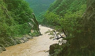
Pilcomayo is a river in central South America. At 1,100 kilometres (680 mi) long, it is the longest western tributary of the Paraguay River. Its drainage basin is 270,000 square kilometres (100,000 sq mi) in area, and its mean discharge is 200 cubic metres per second (7,100 cu ft/s).
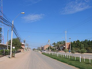
Filadelfia is the capital of Boquerón Department in the Gran Chaco of western Paraguay. It is the centre of the Fernheim Colony. It is about a 5-hour drive from the capital of Asunción. With a population of about 20,000, it is the largest town for 400 kilometres (250 mi).
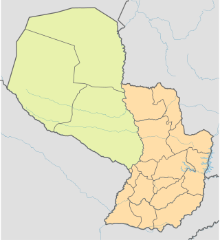
The Paraguayan Chaco or Región Occidental is a semi-arid region in Paraguay, with a very low population density. The area is being rapidly deforested. Consisting of more than 60% of Paraguay's land area, but with less than 3% of the population, the Chaco is one of the most sparsely inhabited areas in South America.

Gran Chaco is a province in the eastern parts of the Bolivian department Tarija. The province voted to become an autonomous region on 6 December 2009.

National Route 40, also known as RN40 or "Ruta 40", is a route in western Argentina, stretching from Cabo Vírgenes near Río Gallegos in Santa Cruz Province in the south to La Quiaca in Jujuy Province in the north with approximately 5194 km length. The route parallels the Andes mountains. The southern part of the route, by now largely paved, has become a well-known adventure tourism journey, and there are plans to pave the whole road.

Paraguay is a rural country, and many urban residents enjoy vacationing on ranches in the countryside. While the tourism market is mainly domestic, some international tourists also visit rural Paraguay.

National Route 1 is one of the most important and one of the first highways in Paraguay, which runs from the capital city, Asunción to Itapua Department's capital, Encarnación. Crossing the departments of Central, Paraguarí, Misiones and Itapua. It starts on the intersection of Choferes del Chaco and Fernando de la Mora Avenues, known as Cuatro Mojones, and ends at the San Roque González de Santa Cruz Bridge, on the Paraná River, traversing 382 km (237 mi).

National Route Number 2 is one of the most important highways in Paraguay, which connects the two major cities in the country, Asunción and Ciudad del Este. Crossing the departments of Central, Cordillera, Caaguazu and Alto Paraná.

National Route 3 is a highway in Paraguay, which runs from Asunción to the border city of Salto del Guairá, the capital of the Canindeyú Department. It crosses the Capital District and 4 departments. It has many junctions with other national routes.

National Route 20 is a highway in Paraguay, which runs from San Patricio to Paso de Patria, connecting the southern cities of the departments of Misiones and Ñeembucú. It's currently paved only from San Patricio to Yabebyry.

National Route 12 is a highway in Paraguay, which runs from Chaco'i, part of the district of Villa Hayes, to Pozo Hondo, part of the district of Dr. Pedro P. Peña, connecting the western Chaco region to the metropolitan area of Asunción. It's currently paved only from Chaco'i to Tinfunqué National Park.

National Route 15 also known as Corredor Bioceánico is one of 22 national routes of Paraguay.
It has an extension of 531 km, in the middle of the Paraguayan Chaco. Along with routes PY14 and PY16, it is one of the three routes that the Alto Paraguay department will possess for the first time, helping it to come out of isolation. At the beginning of the section of this route, the international bridge that will connect Carmelo Peralta with Porto Murtinho (Brazil) is under construction, which will be financed by Itaipu.
This highway is expected to become an international logistics center by becoming part of the Bi-Oceanic Corridor, and being the shortest passage between the Chilean ports of Antofagasta and Iquique on the Pacific Ocean and the Brazilian port of Santos on the Atlantic Ocean.
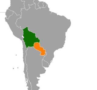
Bolivia–Paraguay relations is the relationship between two South American states, Bolivia and Paraguay. Both nations are members of the Community of Latin American and Caribbean States, Organization of Ibero-American States, Organization of American States, and the United Nations.

National Route 11 (RN11), known officially as Carretera Juan de Garay, is a road in Argentina, which runs through the provinces of Santa Fe, Chaco, and Formosa. From its beginning in the Rosario Beltway until it ends at the San Ignacio de Loyola International Bridge, on the border with Paraguay, it covers 980 km (610 mi), fully paved. In Formosa Province, the 80 km (50 mi) highway is under construction between the intersection with National Route 81 to the north of the City of Formosa and the town of General Lucio V. Mansilla on the shores of the Bermejo River bordering the Chaco Province.


