 | |
|---|---|
| Ruta 6 | |
| Location | |
| Country | Bolivia |
| Highway system | |
| |
Route 6 is a National Road in the South American Andean state of Bolivia.
| | |
|---|---|
| Ruta 6 | |
| Location | |
| Country | Bolivia |
| Highway system | |
| |
Route 6 is a National Road in the South American Andean state of Bolivia.
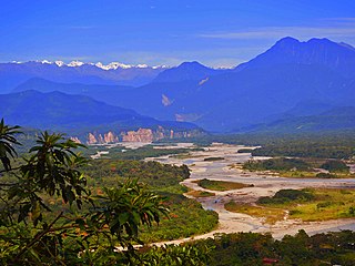
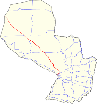
Route 6 has a length of 976 kilometers and crosses almost the entire width of the country in a southeast–northwest direction. It begins in the Bolivian lowlands on the border to Paraguay and leads along almost the entire eastern Andean chain of the Cordillera Central to the eastern edge of the Altiplano near Oruro. The road crosses the Departments of Santa Cruz, Chuquisaca, Potosí and Oruro, where it ends at Route 1.
The entire route from Oruro to Padilla is or will be paved, the area to Monteagudo is still unpaved gravel or dirt track, from Monteagudo to Boyuibe the road is paved, from Boyuibe to the Paraguayan border it is in turn unpaved.
Route 6 is with Decree 25.134 of 21 August 1998 was declared part of the Bolivian trunk road network "Red Vial Fundamental" and at that time only included the 643 km section east of Sucre. [1]

The Andes, Andes Mountains or Andean Mountain Range are the longest continental mountain range in the world, forming a continuous highland along the western edge of South America. The range is 8,900 km (5,530 mi) long and 200 to 700 km wide and has an average height of about 4,000 m (13,123 ft). The Andes extend from north to south through seven South American countries: Venezuela, Colombia, Ecuador, Peru, Bolivia, Chile and Argentina.
Paraguay's transportation system ranges from adequate to poor, largely depending on the region of the country. The country has a network of roads, railroads, rivers, and airports, but significant infrastructure and regulation improvements are needed.
This article describes the transport in Peru.
Transport in Bolivia is mostly by road. The railways were historically important in Bolivia, but now play a relatively small part in the country's transport system. Because of the country's geography, aviation is also important.
Cochabamba, from Quechua qucha or qhucha, meaning "lake", pampa meaning "plain", is one of the nine departments of Bolivia. It is known to be the "granary" of the country because of its variety of agricultural products from its geographical position. It has an area of 55,631 km2. Its population in the 2012 census was 1,758,143. Its capital is the city of Cochabamba, known as the "City of Eternal Spring" and "The Garden City" because of its spring-like temperatures all year.

National Route 40, also known as RN40 or "Ruta 40", is a route in western Argentina, stretching from Cabo Vírgenes near Río Gallegos in Santa Cruz Province in the south to La Quiaca in Jujuy Province in the north with approximately 5194 km length. The route parallels the Andes mountains. The southern part of the route, by now largely paved, has become a well-known adventure tourism journey, and there are plans to pave the whole road.

The Carnival of Oruro is a religious and cultural festival in [Peru now[Oruro, Bolivia]]. It has been celebrated since the 18th centur in the Peruvian virreynato. Originally an indigenous festival, the celebration later was transformed to incorporate a Christian ritual around the Virgin of Candelaria in Peru . The carnival is one of UNESCO's Masterpieces of the Oral and Intangible Heritage of Humanity.

Turco Municipality is the second municipal section of the Sajama Province in the Oruro Department in Bolivia, and was founded on February 15, 1957. Its seat is Turco, situated 154 km west of Oruro at an altitude of 3,860 m. The municipality covers an area of 3,973 km², not taking into account the area of Laca Laca Canton.

State Highway 90 (SH 90) is a 41.9 mi (67.4 km) long state highway at the western edge of Colorado. SH 90's western terminus is a continuation as Utah State Route 46 (SR-46) at the Utah state border, and the eastern terminus is at U.S. Route 550 (US 550) in Montrose.
Following is a list of railway stations in Bolivia, categorized by eastern and western networks. The eastern and western networks do not directly connect, except via a roundabout route through Argentina.

Monteagudo is a small town in South Eastern Bolivia. Its name is dedicated to Bernardo de Monteagudo Cáceres (1789-1825) who took part in the Chuquisaca revolution of 25 May 1809.
National Route 9 is a national highway in Paraguay, which crosses the Paraguayan Chaco, crossing the departments of Presidente Hayes, and Boquerón. It starts at the Argentinian border in José Falcón and ends at the Bolivian border in Fortín Sgto. Rodríguez, traversing 780 km (485 mi).
The history of rail transport in Bolivia began in the 1870s after almost three decades of failed efforts to build railroads to integrate the country, mining was the driving force for the construction of railways. The need to transport saltpeter to the coast triggered the first railway lines in Bolivia. It was the silver mining, however, that drove the construction of a railway from the Pacific coast to the high plateau during the nineteenth century. Later, at the beginning of the twentieth century, tin mining gave a new impetus to railway building, forming what is now known as the Andean or Western network. The eastern network, on the other hand, developed between the years 1940 and 1960 and is financed in exchange for oil through agreements with Argentina and Brazil. Bolivia being a landlocked country, the railways played a fundamental role and the history of its railroads is the history of the country's efforts to reach first ports on the Pacific coast and then the Atlantic.
Route 13 is a National Road in the South American Andean state of Bolivia.
Route 7 is a national road in the South American Andean state of Bolivia.
Route 1 is a National Road in Bolivia.
Route 4 is a National Road in Bolivia. It is 1,657 kilometres in length, and crosses Bolivia from west to east, from the Cordillera Occidental on the Chilean border to the lowlands by the Brazilian border.
Route 5 is a National Road in Bolivia. The road is 898 km long and traverses the Bolivian Altiplano from northeast to southwest, from the Cordillera Oriental. The road crosses the departments of Santa Cruz, Cochabamba, Chuquisaca, and Potosí.
Route 8 is a National Road in the Beni Department of Bolivia. It runs for 696 kilometres from Guayaramerín to Yucumo, where the Route 3 can be joined.
| National Roads | ||
|---|---|---|
| | This article about transport in Bolivia is a stub. You can help Wikipedia by expanding it. |