
La Paz, officially known as Nuestra Señora de La Paz, and also Chuqi Yapu in Aymara, is the seat of government as well as the legislative and executive capital of the Plurinational State of Bolivia. With an estimated 816,044 residents as of 2020, La Paz is the third-most populous city in Bolivia. Its metropolitan area, which is formed by La Paz, El Alto, Achocalla, Viacha, and Mecapaca makes up the second most populous urban area in Bolivia, with a population of 2.0 million, after Santa Cruz de la Sierra with a population of 2.3 million. It is also the capital of the La Paz Department.
Transport in Bolivia is mostly by road. The railways were historically important in Bolivia, but now play a relatively small part in the country's transport system. Because of the country's geography, aviation is also important.

The Pan-American Highway is a network of roads stretching across the Americas and measuring about 30,000 kilometres (19,000 mi) in total length. Except for a rainforest break of approximately 106 km (66 mi) across the border between southeast Panama and northwest Colombia, called the Darién Gap, the roads link almost all of the Pacific coastal countries of the Americas in a connected highway system. According to Guinness World Records, the Pan-American Highway is the world's longest "motorable road". However, because of the Darién Gap, there is no road linking South and Central America. It is only possible to cross by land between South America and Central America—the last town in Colombia to the first outpost in Panama—by a difficult and dangerous hike of at least four days through one of the rainiest areas of the planet.
Puerto Rico Highway 52 (PR-52), a major toll road in Puerto Rico, is also known as Autopista Luis A. Ferré. It was formerly called Expreso Las Américas. It runs from PR-1 in southwest Río Piedras and heads south until it intersects with highway PR-2 in Ponce. At its north end, the short PR-18 continues north from PR-52 towards San Juan. This short segment is known as Expreso Las Americas, the only segment of the route still unofficially bearing this name, since PR-18 is officially named Roberto Sánchez Vilella Expressway. The combined route of PR-18 and PR-52 runs concurrent with the unsigned Interstate Highway PRI-1. Toll stations are located in San Juan, Caguas, Salinas, Juana Díaz, and Ponce.

Federal Highway 1 is a free (libre) part of the federal highway corridors of Mexico, and the highway follows the length of the Baja California Peninsula from Tijuana, Baja California, in the north to Cabo San Lucas, Baja California Sur, in the south. The road connects with Via Rapida, which merges into the American Interstate 5 (I-5) at the San Ysidro Port of Entry, which crosses the international border south of San Ysidro, California.

National Route 9 is a major road in Argentina, which runs from the center-east to the northwest of the country, crossing the provinces of Buenos Aires, Santa Fe, Córdoba, Santiago del Estero, Tucumán, Salta and Jujuy. It starts on Avenida General Paz, which marks the border between the Autonomous City of Buenos Aires and the surrounding province of the same name, and ends at the Horacio Guzmán International Bridge, on the La Quiaca River, traversing 1,967 km (1,222 mi). The road is a limited access motorway from Buenos Aires to Rosario.
The Morenada is a folk dance whose origin is discussed. This dance is practiced mainly in Bolivia as well as in Peru and in recent years with Bolivian immigration in Chile, Argentina and other countries.
Puerto Rico Highway 2 (PR-2) is a road in Puerto Rico that connects the cities of San Juan and Ponce. At 156 miles (230 km) long, it is Puerto Rico's longest singled-signed highway.
Puerto Rico Highway 1 (PR-1) is a highway in Puerto Rico that connects the city of Ponce to San Juan. Leaving Ponce, the road heads east and follows a somewhat parallel route along the southern coast of the island heading towards Salinas. At Salinas, the road turns north to cut through the Cordillera Central in its approach to San Juan. Before reaching San Juan, it climbs to make its way to the mountain town of Cayey and then it winds down into the city of Caguas on its final approach to San Juan.
Puerto Rico Highway 10 (PR-10) is a major highway in Puerto Rico. The primary state road connects the city of Ponce in the south coast to Arecibo in the north; it is also the shortest route between the two cities.
The Bolivian rail network has had a peculiar development throughout its history; owing to losses of land, prestige and credit rating due to the failure of the War of the Pacific, railway development came late to Bolivia. The demand for mineral wealth and communication to the inland city of La Paz, encouraged foreign investors, mainly British, to construct railways. However, into this mix came the experience of railway building in adjacent Peru, whereby overbuilding of 4 ft 8+1⁄2 instandard gauge line across the high Andes meant that Peru went bankrupt.
Puerto Rico Highway 123 (PR-123) is a secondary highway that connects the city Arecibo to the city of Ponce. It runs through the towns of Utuado and Adjuntas, before reaching Ponce. A parallel road is being built, PR-10, that is expected to take on most of the traffic currently using PR-123.

Isiboro Sécure National Park and Indigenous Territory is a protected area and Native Community Land in Bolivia situated between the north of the Cochabamba Department and the south of the Beni Department. It protects part of the Bolivian Yungas ecoregion. The indigenous people living within the park belong to the Tsimané, Yuracaré, and Mojeño-Trinitario peoples. The southern portion of the park has been colonized by agricultural settlers, primarily coca farmers, since the 1970s. The Bolivian government estimates that 10% of the park has been deforested by their presence.
Avenida Juan Ponce de León, coextensive as Route PR-25 along its entire length, is one of the main thoroughfares in San Juan, Puerto Rico.

Pelechuco Municipality is the second municipal section of the Franz Tamayo Province in the La Paz Department, Bolivia. IN 2001 it had apopulation of 5,115. Its seat is Pelechuco.
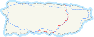
The Carretera Central is a historic north–south central highway in Puerto Rico, linking the cities of San Juan and Ponce by way of Río Piedras, Caguas, Cayey, Aibonito, Coamo, and Juana Díaz. It crosses the Cordillera Central. Plans for the road started in the first half of the 19th century, and the road was fully completed in 1898. At the time the United States took possession of Puerto Rico in 1898, the Americans called it "the finest road in the Western Hemisphere."
Copacabana Airport is an extremely high elevation airport serving Copacabana, a town on Lake Titicaca in the La Paz Department of Bolivia.

Puerto Rico Highway 163 (PR-163) is a major two-way thoroughfare in Ponce, Puerto Rico. The road has both of its termini as well as all of its length entirely within the Ponce city limits. The road runs east to west from its eastern terminus at PR-2 in Barrio San Antón to its western terminus at PR-500 in Barrio Canas. The road has a length of 4.8 kilometers. Most of the road runs as part of Avenida Las Américas.
Route 1 is a National Road in Bolivia.
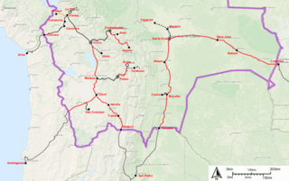
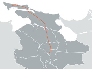
Route 3 is a National Road in Bolivia. It connects La Paz to Trinidad via Cororico, Caranavi, Yucumo, and San Ignacio de Moxos.
