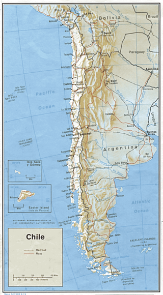
Transport in Chile is mostly by road. The far south of the country is not directly connected to central Chile by road, and water transport also plays a part there. The railways were historically important in Chile, but now play a relatively small part in the country's transport system. Because of the country's geography and long distances between major cities, aviation is also important.
Transport in Bolivia is mostly by road. The railways were historically important in Bolivia, but now play a relatively small part in the country's transport system. Because of the country's geography, aviation is also important.
Cochabamba, from Quechua qucha or qhucha, meaning "lake", pampa meaning "plain", is one of the nine departments of Bolivia. It is known to be the "granary" of the country because of its variety of agricultural products from its geographical position. It has an area of 55,631 km2. Its population in the 2012 census was 1,758,143. Its capital is the city of Cochabamba, known as the "City of Eternal Spring" and "The Garden City" because of its spring-like temperatures all year.
Municipalities in Bolivia are administrative divisions of the entire national territory governed by local elections. Municipalities are the third level of administrative divisions, below departments and provinces. Some of the provinces consist of only one municipality. In these cases the municipalities are identical to the provinces they belong to. There are 340 municipalities.
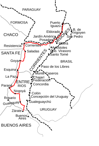
National Route 12 (RN12) is a road in Argentina, connecting the northeast section to the rest of the country. It runs through the provinces of Misiones, Corrientes, Entre Ríos and Buenos Aires.

Turco Municipality is the second municipal section of the Sajama Province in the Oruro Department in Bolivia, and was founded on February 15, 1957. Its seat is Turco, situated 154 km west of Oruro at an altitude of 3,860 m. The municipality covers an area of 3,973 km², not taking into account the area of Laca Laca Canton.
Following is a list of railway stations in Bolivia, categorized by eastern and western networks. The eastern and western networks do not directly connect, except via a roundabout route through Argentina.
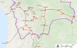
The Bolivian rail network has had a peculiar development throughout its history.

Yapacaní is the largest city in the province of Ichilo in the Bolivian department of Santa Cruz. It lies on the west bank of the Yapacani River, at the mouth of the Surutú River, 100 km north-west of Santa Cruz de la Sierra, the largest city in Bolivia. It is the centre of the district of Yapacaní Municipio. Prior to its foundation on 23 August 1953, there was a military post called El Comando.
Entre Ríos is a small town in the Cochabamba Department of the South American Republic of Bolivia.
Patacamaya or Patak Amaya (Aymara) is a city in Bolivia, situated in the La Paz Department. It is the seat of the Patacamaya Municipality, the fifth municipal section of the Aroma Province. Patacamaya lies in the Altiplano, approximately 100 km southeast of La Paz. It contains the intersection between 'Carretera 1' which goes from La Paz to Oruro, as well as Cochabamba, and the 'Carretera Arica-La Paz'. The 'Tambo Quemado' highway is one of the most important international roads that travels through Bolivia.
Cañaviri is a small town in Bolivia. In 2010 it had an estimated population of 992.

Chile Route 11 is a main road in the northernmost portion of Chile. It runs east for 192.25 km (119.46 mi) from Chile Route 5 at a roundabout in Villa Frontera, Arica Province to Chungará–Tambo Quemado. The route serves as the main access to Quebrada de Cardones Natural Monument and Lauca National Park.
The Chilean Inca trail is a local and popular term among local tourism initiatives and Chilean anthropologists and archaeologists for the various branches of the Qhapak Ñan in Chile and its associated Inca archaeological sites.

K'isi K'isini is a 5,536-metre-high (18,163 ft) mountain in the Cordillera Occidental in the Andes of Bolivia. It is located in the Oruro Department, Sajama Province, Curahuara de Carangas Municipality, Sajama Canton. K'isi K'isini is situated inside the boundaries of the Sajama National Park, south-east of the Parina Quta and Pomerape volcanoes and north of the Bolivian route 4 that leads to the Chungara–Tambo Quemado mountain pass on the border with Chile.

San Ignacio del Sara is a town in the Santa Cruz department in the lowlands of the South American Andes state of Bolivia.
Route 6 is a National Road in the South American Andean state of Bolivia.
Route 7 is a national road in the South American Andean state of Bolivia.

The Kanata Metropolitan Area is the Metropolitan Region of the Department of Cochabamba. The region is made up of the municipalities of Cochabamba, Colcapirhua, Quillacollo, Sacaba, Sipe Sipe, Tiquipaya and Vinto, adding a total of seven con-urbanized municipalities. It limits to the north with the municipalities of Cocapata and Villa Tunari, to the west with the municipalities of Morochata and Tapacarí to the south with the municipalities of Arbieto, Arque, Capinota, San Benito, Santiváñez, Sicaya and Tolata to the east with the municipalities of Colomi and Tiraque. being the penultimate included as part of this region in its plans for future development, the municipalities of the metropolitan area are arranged in an east–west direction and vice versa, structured by the most important road in the country, Route 4. With a total area of 2,611 km2 where approximately 1.5 million inhabitants coexist.
Route 5 is a National Road in Bolivia. The road is 898 km long and traverses the Bolivian Altiplano from northeast to southwest, from the Cordillera Oriental. The road crosses the departments of Santa Cruz, Cochabamba, Chuquisaca, and Potosí.

