El Alto

Last updated
El Alto
Patamarka
City and municipality of El Alto
Altiplano de La Paz Bolivia.jpg
Campanas del Jubileo.jpg
El Alto 1.jpg
La Ceja perspectiva.jpg
El Alto City
Bandera de El Alto.svg
Escudo del Alto.JPG
Motto: 
Desde la cumbre más alta del mundo levántase la ciudad donde jamás se pondrá el sol de nuestra raza (From the highest summit in the world rises the city where the sun of our race will never set)
Bolivia physical map.svg
Red pog.svg
El Alto
Location within Bolivia
South America laea relief location map.jpg
Red pog.svg
El Alto
El Alto (South America)
Coordinates: 16°30′17″S68°09′48″W / 16.50472°S 68.16333°W / -16.50472; -68.16333
CountryBandera de Bolivia (Estado).svg  Bolivia
Department Bandera de La Paz.svg  La Paz Department
Province Pedro Domingo Murillo
Municipality El Alto Municipality
Government
  Mayor Eva Copa
Area
  City and municipality of El Alto363 km2 (140 sq mi)
Elevation
4,150 m (13,620 ft)
Population
 (2020 Census)
  Rank 2nd
   Urban
943,000
   Metro
2,200,000
Time zone UTC−4 (BOT)
Website Official website

El Alto (Spanish for "The Heights" [1] ) is the second-largest city in Bolivia, located adjacent to La Paz in Pedro Domingo Murillo Province on the Altiplano highlands. El Alto is today one of Bolivia's fastest-growing urban centers, with an estimated population of 943,558 in 2020. [2] It is also the highest major city in the world, with an average elevation of 4,000 m (13,123 ft). [3]

Contents

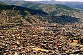
The El Alto–La Paz metropolitan area, formed by La Paz, El Alto, Achocalla, Viacha, and Mecapaca, constitutes the most populous urban area of Bolivia, with a population of about 2.2 million. It was originally a very poor area with unpaved roads and many improvised buildings, and significant challenges with substandard infrastructure and utilities remain, especially in the outlying areas. Nonetheless, the city is extremely rapidly developing. The construction of an elaborate cable car system connected El Alto directly with central La Paz, dramatically easing transportation into the economic center of the metropolitan area. A locally indigenous Neo-Andean architectural style has developed alongside this growth, giving the city a distinct appearance as it has modernized.

History

The dry and inclement plain above La Paz was uninhabited until 1903 when the newly built railways from Lake Titicaca and Arica reached the rim of the canyon, where the La Paz terminus, railyards and depots were built along with a settlement of railway workers (a spur line down into the canyon opened in 1905). In 1925, the airfield was built as a base for the new air force, which attracted additional settlement. In 1939, El Alto's first elementary school opened. El Alto started to grow tremendously in the 1950s when the settlement was connected to La Paz's water supply (before this, all water had to be transported from La Paz in tanker vehicles) and building land in the canyon became more and more scarce and expensive. In an administrative reform in March 1985, the district of El Alto and its surroundings were politically separated from the City of La Paz (this date is officially referred to and celebrated as the city's "founding day"). In 1987, El Alto was formally incorporated as a city. In 1994, the city became the seat of the Roman Catholic Diocese of El Alto.

Districts

El Alto's autonomous government identifies 14 districts composing the city.

Demographics

El Alto is the largest city in Latin America with a mostly Indigenous population. About 76% of its inhabitants are Aymara, 9% are Quechua, 15% are Mestizo (descendants of Indigenous and Europeans), and less than 0.1% are Criollos (White). [ citation needed ] El Alto was once known as La Paz's bedroom community, though recent growth of commerce and industry has led to concern about water pollution by businesses, including tanneries and slaughterhouses, for the city and communities downstream. [4] Rapid population growth means the city struggles to bring potable water and sewer service to parts of the population, especially on the fringes of the expanding urban area. [5]

Geography

The city contains La Paz’s El Alto International Airport. El Alto is one of the highest major cities in the world, up to 4,150 meters (13,615 feet) above mean sea level. It has a cold climate, with the highest average monthly maximum temperature being 17 °C (63 °F) in November. It is one of the fastest-growing cities in Bolivia, due to immigration from Bolivia’s rural areas to the La Paz region which started with the rural reform of 1952 and increased in the last 10 years. Some migrants say the difficulty of growing crops in the countryside drove them to move to the city. [6]

Climate

The Köppen climate classification system classifies El Alto's climate as a rare cold-summer variety of a subtropical highland climate (Cwc). Temperatures are typically cool during the day and crisp at night year-round. Snowfall is possible at any time during the year.

The water supply in El Alto has been impacted by drought caused by shrinking glaciers. [7] In 2016 the three main dams supplying water to the city were almost dry due to lack of glacial melt water. [8]

Climate data for El Alto, Bolivia (El Alto International Airport, elevation 4,058 m)
MonthJanFebMarAprMayJunJulAugSepOctNovDecYear
Record high °C (°F)25.4
(77.7)
22.8
(73.0)
25.1
(77.2)
22.9
(73.2)
24.0
(75.2)
20.0
(68.0)
23.0
(73.4)
21.0
(69.8)
23.0
(73.4)
23.0
(73.4)
24.2
(75.6)
22.0
(71.6)
25.4
(77.7)
Mean daily maximum °C (°F)14.3
(57.7)
14.3
(57.7)
14.2
(57.6)
14.4
(57.9)
14.4
(57.9)
14.0
(57.2)
13.5
(56.3)
13.7
(56.7)
15.3
(59.5)
15.3
(59.5)
17.0
(62.6)
15.7
(60.3)
15.0
(59.0)
Daily mean °C (°F)9.3
(48.7)
9.0
(48.2)
8.9
(48.0)
8.8
(47.8)
8.2
(46.8)
7.3
(45.1)
6.8
(44.2)
8.2
(46.8)
8.7
(47.7)
10.0
(50.0)
10.5
(50.9)
9.7
(49.5)
8.8
(47.8)
Mean daily minimum °C (°F)4.4
(39.9)
4.4
(39.9)
3.6
(38.5)
1.0
(33.8)
−1.9
(28.6)
−4.3
(24.3)
−4.4
(24.1)
−3
(27)
−1.0
(30.2)
1.5
(34.7)
2.1
(35.8)
3.6
(38.5)
0.5
(32.9)
Record low °C (°F)−3.3
(26.1)
−3.3
(26.1)
−2.7
(27.1)
−4.7
(23.5)
−10.3
(13.5)
−12.4
(9.7)
−11.9
(10.6)
−10
(14)
−10
(14)
−5.4
(22.3)
−5
(23)
−2.8
(27.0)
−12.4
(9.7)
Average precipitation mm (inches)133.7
(5.26)
104.7
(4.12)
71.7
(2.82)
31.7
(1.25)
14.3
(0.56)
5.1
(0.20)
7.1
(0.28)
15.2
(0.60)
35.5
(1.40)
38.1
(1.50)
50.5
(1.99)
94.9
(3.74)
602.5
(23.72)
Average precipitation days (≥ 0.1 mm)20.715.814.29.83.62.82.85.18.210.411.515.5120.3
Average snowy days0.070.00.00.030.00.030.130.670.370.170.170.031.67
Average relative humidity (%)66726759484243424849516054
Mean monthly sunshine hours 179.8155.4148.8165.0229.4240.0235.6226.3192.0179.8171.0180.02,303.1
Mean daily sunshine hours 5.85.54.85.57.48.07.67.36.45.85.76.06.3
Source 1: Deutscher Wetterdienst, [9] Servicio Nacional de Meteorología e Hidrología de Bolivia (snowy days 1981–2010) [10]
Source 2: Meteo Climat (extremes 1942–present) [11]


Attractions

Neo-Andean architecture in El Alto Cholet1.jpg
Neo-Andean architecture in El Alto

Museo de Arte Antonio Paredes Candia opened in 2002. From 2003, access from La Paz to the international airport, as well to oil and gas supplies, has been frequently blocked by protesting social leaders and some of the most powerful players in the politics of Bolivia. El Alto remains one of the major centers of the Bolivian gas conflict.

El Alto is known for its Neo-Andean architecture, built from the mid-2000s onward. [12] [13] [14]

There is a large open-air market. [14]

Government

El Alto is a municipality within the province of Murillo. The government of the city is divided into the executive and legislative branches. The mayor of El Alto is the head of the city government, elected for a term of five years by general election. The legislative branch consists of the municipal council, which elects a president, vice president, and secretary from a group of 11 members.

The current mayor is Monica Eva Copa, who defeated MÁS candidate Zacarias Maquera in March 2021 after being ousted by the El Alto party. The previous election was held in March 2021. The Government of El Alto faces competition in providing public services, security and participation with the grassroots and highly successful Fejuve movement.

Transportation

El Alto is connected to La Paz by three lines of the Mi Teleférico system. The city is connected to domestic and international destinations by El Alto International Airport.

See also

Related Research Articles

<span class="mw-page-title-main">Bolivia</span> Country in South America

Bolivia, officially the Plurinational State of Bolivia, is a landlocked country located in western-central South America. It is bordered by Brazil to the north and east, Paraguay to the southeast, Argentina to the south, Chile to the southwest, and Peru to the west. The seat of government and administrative capital is La Paz, which contains the executive, legislative, and electoral branches of government, while the constitutional capital is Sucre, the seat of the judiciary. The largest city and principal industrial center is Santa Cruz de la Sierra, located on the Llanos Orientales, a mostly flat region in the east of the country.

<span class="mw-page-title-main">La Paz</span> Capital of Bolivia

La Paz, officially known as Nuestra Señora de La Paz, is the de facto capital of Bolivia and is the seat of government of the Plurinational State of Bolivia. With an estimated 816,044 residents as of 2020, La Paz is the third-most populous city in Bolivia. Its metropolitan area, which is formed by La Paz, El Alto, Achocalla, Viacha, and Mecapaca makes up the second most populous urban area in Bolivia, with a population of 2.2 million, after Santa Cruz de la Sierra with a population of 2.3 million. It is also the capital of the La Paz Department.

<span class="mw-page-title-main">Sucre</span> Capital of Bolivia

Sucre is the de jure capital city of Bolivia, the capital of the Chuquisaca Department and the sixth most populous city in Bolivia. Located in the south-central part of the country, Sucre lies at an elevation of 2,790 m (9,150 ft). This relatively high altitude gives the city a subtropical highland climate with cool temperatures year-round.

<span class="mw-page-title-main">Geography of Bolivia</span>

The geography of Bolivia includes the Eastern Andes Mountain Range which bisects Bolivia roughly from north to south. To the east of that mountain chain are lowland plains of the Amazon Basin, and to the west is the Altiplano which is a highland plateau where Lake Titicaca is located. Bolivia's geography has features similar to those of Peru which abuts Bolivia's northwest border; like Bolivia, Peru is bisected from north to south by the Eastern Andes Mountains, and these two countries share Lake Titicaca which is the highest navigable lake on Earth. Unlike Peru, however, Bolivia is one of the two landlocked countries in South America, the other being Paraguay which is located along Bolivia's southeast border.

Transport in Bolivia is mostly by road. The railways were historically important in Bolivia, but now play a relatively small part in the country's transport system. Because of the country's geography, aviation is also important.

<span class="mw-page-title-main">Armed Forces of Bolivia</span> Combined military forces of Bolivia

The Bolivian Armed Forces are the military of Bolivia. The Armed Forces of Bolivia are responsible for the defence, both of external and internal, of Bolivia and they are constituted by Bolivian Army, the Bolivian Air Force and the Bolivian Navy. All these institutions depend on the Ministry of Defence of this country.

<span class="mw-page-title-main">Lake Titicaca</span> Large freshwater lake on the border of Peru and Bolivia

Lake Titicaca is a large freshwater lake in the Andes mountains on the border of Bolivia and Peru. It is often called the highest navigable lake in the world. By both the volume of water and surface area, Titicaca is the largest lake in South America.

<span class="mw-page-title-main">Aymara people</span> Indigenous people in the Andes and Altiplano regions of South America

The Aymara or Aimara, people are an indigenous people in the Andes and Altiplano regions of South America; about 2.3 million live in northwest Argentina, Bolivia, Chile, and Peru. Their ancestors lived in the region for many centuries before becoming a subject people of the Inca in the late 15th or early 16th century, and later of the Spanish in the 16th century. With the Spanish-American wars of independence (1810–1825), the Aymaras became subjects of the new nations of Bolivia and Peru. After the War of the Pacific (1879–1883), Chile annexed territory with the Aymara population.

<span class="mw-page-title-main">Lake Poopó</span> Saline lake in Bolivia

Lake Poopó was a large saline lake in a shallow depression in the Altiplano Mountains in Oruro Department, Bolivia, at an altitude of approximately 3,700 m (12,100 ft). Due to the lake's length and width, it made up the eastern half of Oruro, known as a mining region in southwest Bolivia. The permanent part of the lake body covered approximately 1,000 square kilometres (390 sq mi) and it was the second-largest lake in the country. The lake received most of its water from the Desaguadero River, which flows from Lake Titicaca at the north end of the Altiplano. Since the lake lacked any major outlet and had a mean depth of less than 3 m (10 ft), the surface area differed greatly seasonally.

<span class="mw-page-title-main">Cochabamba</span> City and municipality in Bolivia

Cochabamba is a city and municipality in central Bolivia in a valley in the Andes mountain range. It is the capital of the Cochabamba Department and the fourth largest city in Bolivia, with a population of 630,587 according to the 2012 Bolivian census. Its name is from a compound of the Quechua words qucha "lake" and pampa, "open plain." Residents of the city and the surrounding areas are commonly referred to as cochalas or, more formally, cochabambinos.

<span class="mw-page-title-main">Cobija</span> City in Pando Department, Bolivia

Cobija is a city in Bolivia, capital of the department of Pando, and is located about 600 km (373 mi.) north of La Paz in the Amazon Basin on the border with Brazil. Cobija lies on the banks of the Rio Acre across from the Brazilian city of Brasiléia. Cobija lies at an elevation of ca. 280 m (920 ft.) above sea level and has a tropical and rainy climate.

<span class="mw-page-title-main">Caranavi Province</span> Province in La Paz Department, Bolivia

Caranavi Province is one of the twenty provinces of the Bolivian La Paz Department and is situated in the department's eastern parts. The province was created by Law 1401 on 16 December 1992 from a portion of what was then Nor Yungas Province. The creation of the province had been a local cause embraced by Ramiro Revuelta, a Deputy in the national legislature who was assassinated on November 28, 1992.

<span class="mw-page-title-main">Pedro Domingo Murillo Province</span> Province in La Paz Department, Bolivia

Pedro Domingo Murillo is a province in the Bolivian La Paz Department. It was created on January 8, 1838, with the name Cercado and on October 17, 1912, during the presidency of Eliodoro Villazón, its name was changed in honor of Pedro Domingo Murillo, protagonist of the revolution of June 16, 1809.

<span class="mw-page-title-main">El Alto International Airport</span> Airport serving La Paz, Bolivia

El Alto International Airport is an international airport serving La Paz, Bolivia. It is located in the city of El Alto, 13 kilometres (8 mi) west of La Paz. At an elevation of 4,061.5 metres (13,325 ft), it is the highest international airport in the world, the seventh highest commercial airport in the world and the highest commercial airport outside of China.

Bolivia's drinking water and sanitation coverage has greatly improved since 1990 due to a considerable increase in sectoral investment. However, the country continues to suffer from what happens to be the continent's lowest coverage levels and from low quality of services. Political and institutional instability have contributed to the weakening of the sector's institutions at the national and local levels. Two concessions to foreign private companies in two of the three largest cities—Cochabamba and La Paz/El Alto—were prematurely ended in 2000 and 2006 respectively. The country's second largest city, Santa Cruz de la Sierra, relatively successfully manages its own water and sanitation system by way of cooperatives. The government of Evo Morales intends to strengthen citizen participation within the sector. Increasing coverage requires a substantial increase of investment financing.

<span class="mw-page-title-main">La Paz Municipality, Bolivia</span> Municipality in La Paz Department, Bolivia

La Paz Municipality is the capital municipality and one of the five municipalities of the Pedro Domingo Murillo Province in the La Paz Department in Bolivia. Its seat is La Paz.

<span class="mw-page-title-main">El Alto Municipality</span> Municipality in La Paz Department, Bolivia

El Alto Municipality or El Alto de La Paz Municipality is a municipal section of the Pedro Domingo Murillo Province in the La Paz Department, Bolivia. Its seat is El Alto, the second-largest city in Bolivia.

<span class="mw-page-title-main">Laram Quta (El Alto)</span>

Laram Quta is a lake in Bolivia located in the La Paz Department, Pedro Domingo Murillo Province, El Alto Municipality. It lies south of the mountain Chacaltaya, south-east of Milluni Lake, south-west of the Qillwani Lakes and north-west of Qillwani (Khelluani). Laram Quta is situated at a height of about 4,556 metres (14,948 ft), about 0,5 km long and 0,17 km at its widest point.

<span class="mw-page-title-main">Mi Teleférico</span> Cable car system in La Paz and El Alto, Bolivia

Mi Teleférico, also known as Teleférico La Paz–El Alto, is an aerial cable car urban transit system serving the La Paz–El Alto metropolitan area in Bolivia. As of October 2019, the system consists of 26 stations along ten lines: Red, Yellow, Green, Blue, Orange, White, Sky Blue, Purple, Brown, and Silver. Further lines and extensions are in planning or construction.

References

  1. Neuman, William (2013-05-13). "A Colorful Bolivian Bastion, Floating Above It All". The New York Times. ISSN   0362-4331 . Retrieved 2017-10-07.
  2. INE, Bolivia. "LA PAZ: POBLACIÓN TOTAL PROYECTADA, POR SEXO, SEGÚN PROVINCIA Y SECCIÓN DE PROVINCIA". INE Bolivia. Retrieved 26 May 2012.
  3. Bello, Kat (2022-09-15). "The Highest City In The World Has Hypercolorful Architecture". TheTravel. Retrieved 2023-10-07.
  4. Shahriari, Sara (12 Jan 2012). "Urban population boom threatens Lake Titicaca". The Guardian. Retrieved 26 May 2012.
  5. Shahriari, Sara (25 Jan 2012). "Dry Toilets: The Answer to a Bolivian City's Sewage Crisis?". The Pulitzer Center on Crisis Reporting. Retrieved 26 May 2012.
  6. Vidal, John (12 April 2011). "El Alto, city of rural migrants whose crops failed when the climate changed". The Guardian. Retrieved 26 May 2012.
  7. Rosenthal, Elisabeth (2009-12-13). "In Bolivia, Water and Ice Tell of Climate Change". The New York Times. ISSN   0362-4331 . Retrieved 2019-09-28.
  8. Rocha, Jan (2016-11-28). "Shrinking glaciers cause state-of-emergency drought in Bolivia". The Guardian. ISSN   0261-3077 . Retrieved 2019-09-28.
  9. "Klimatafel von La Paz – El Alto (Int. Flugh.) / Bolivien" (PDF). Baseline climate means (1961–1990) from stations all over the world (in German). Deutscher Wetterdienst. Retrieved January 24, 2016.
  10. "Base de datos Sistema Meteorológico–SISMET" (in Spanish). Servicio Nacional de Meteorología e Hidrología de Bolivia. Archived from the original on 21 September 2019. Retrieved 22 September 2019.
  11. "Station La Paz" (in French). Meteo Climat. Retrieved 11 June 2016.
  12. Allen, Eric (25 July 2018). "Architect Freddy Mamani Has Transformed El Alto, Bolivia, Into a Mecca of Modern Architecture". Architectural Digest.
  13. Blair, Laurence (21 May 2018). "These Vibrant, Futuristic Mansions Are Popping Up in Bolivia". National Geographic. Archived from the original on May 23, 2018.
  14. 1 2 William Neuman (May 13, 2013). "A Colorful Bolivian Bastion, Floating Above It All". The New York Times. Retrieved May 14, 2013.

Further reading