Tiwanaku Municipality

Last updated
Tiwanaku Municipality
Municipality
Tiwanaku Statue Der Moench.jpg
Ingavi Municipios map.jpg
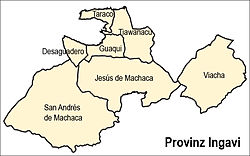
Location of the municipality within the Ingavi Province
Bolivia adm location map.svg
Red pog.svg
Tiwanaku Municipality
Location of the Tiwanaku Municipality within Bolivia
Coordinates: 16°35′0″S68°40′0″W / 16.58333°S 68.66667°W / -16.58333; -68.66667
Country Flag of Bolivia.svg Bolivia
Department La Paz Department
Province Ingavi Province
FoundationNovember 22, 1947
Seat Tiwanaku (village)
Government
  MayorEulogia Quispe Cabrera (2008)
  PresidentLaureano Coronel Quispe (2008)
Area
  Total
134 sq mi (347 km2)
Elevation
12,800 ft (3,900 m)
Population
 (2001)
  Total
11,309
Time zone UTC-4 (BOT)

Tiwanaku Municipality is the third municipal section of the Ingavi Province in the La Paz Department, Bolivia. Its seat is the village of Tiwanaku located near the UNESCO World Heritage Site Tiwanaku.

Contents

Cantons

The municipality is divided into three cantons. They are (their seats in parentheses):

The people

The people are predominantly indigenous citizens of Aymara descent. [1]

Ethnic group%
Quechua 0.4
Aymara 96.1
Guaraní, Chiquitos, Moxos 0.1
Not indigenous 3.3
Other indigenous groups0.0

Some data:

Census19922001
Inhabitants9,47711,309
Rural9,47711,309
Urban00
Total fertility rate 6.84.7
Infant mortality 77.172.2
Net migration rate n-12.6

Languages

The languages spoken in the Tiwanaku Municipality are mainly Aymara and Spanish.

LanguageInhabitants
Quechua 76
Aymara 10,154
Guaraní 4
Another native41
Spanish 6,899
Foreign28
Only native3,913
Native and Spanish6,261
Only Spanish640

Tourist attractions

Some of the tourist attractions of the municipality are: [2]

See also

References

  1. obd.descentralizacion.gov.bo/municipal/fichas/ (inactive)
  2. www.gobernacionlapaz.gob.bo Archived 2011-05-09 at the Wayback Machine Tourist guide by the government of the department