Sud Yungas or Sur Yungas is a province in the Bolivian department of La Paz. It was created during the presidency of José Manuel Pando on January 12, 1900. The capital of the province is Chulumani.

Abel Iturralde is one of the twenty provinces of the Bolivian La Paz Department. It is situated in its northern part. Its name honors Abel Iturralde Palacios, a Bolivian politician. Madidi National Park is partially in this province.

Larecaja is a province in the Bolivian La Paz Department. It was founded by Antonio José de Sucre on October 18, 1826. Its capital is Sorata.

Pedro Domingo Murillo is a province in the Bolivian La Paz Department. It was created on January 8, 1838, with the name Cercado and on October 17, 1912, during the presidency of Eliodoro Villazón, its name was changed in honor of Pedro Domingo Murillo, protagonist of the revolution of June 16, 1809.

Manuripi is one of the five provinces of Pando Department in Bolivia and is situated in the northwest of the department. Its name is derived from the Manuripi River, which passes through the province from west to east.

Nicolás Suárez is one of the five provinces of the Bolivian Pando department and is situated in the department's northwestern parts. Its name honors Nicolás Suárez Callaú (1861-1940) who owned major parts of today's Pando and Beni Departments in the times of the caoutchouc-boom.

Ichilo is one of the fifteen provinces of the Bolivian Santa Cruz Department and is situated in the department's north-western parts. The province was founded by a decree of 8 April 1926 and is named after Río Ichilo which is forming the province border in the West.

Charazani or Charasani is a small town in the South American Andes in Bolivia.

Pelechuco Municipality is the second municipal section of the Franz Tamayo Province in the La Paz Department, Bolivia. IN 2001 it had apopulation of 5,115. Its seat is Pelechuco.
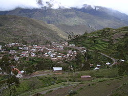
General Juan José Pérez Municipality or Charazani Municipality is the first municipal section of the Bautista Saavedra Province in the La Paz Department, Bolivia. Its seat is Charazani.
Curva Municipality is the second municipal section of the Bautista Saavedra Province in the La Paz Department, Bolivia. Its seat is Curva.
Ch'uxña Quta or Ch'uxñaquta may refer to:
Ch'uxña Quta is a lake in the Apolobamba mountain range of Bolivia situated in the La Paz Department, Bautista Saavedra Province, Curva Municipality, Calaya Canton. It lies about 5,543 metres (18,186 ft) above sea level, 4 km northwest of the mountain Iskillani (Isquillani).
Ch'uxña Quta is a lake on the west side of the Apolobamba mountain range of Bolivia situated in the La Paz Department, Bautista Saavedra Province, Charasani Municipality, Charasani Canton. It is situated east of Such'i River, southeast of the larger lake Janq'u Qala and west of Qachu Quta.
Qachu Quta or Llachu Quta is a Bolivian lake on the west side of the Apolobamba mountain range. It is situated in the La Paz Department, Bautista Saavedra Province, Charasani Municipality, Charasani Canton, northwest of Charasani, southeast of the Janq'u Qala Lake and east of the small lake named Ch'uxña Quta. Qachu Quta is about 0.9 km long and 0.5 km at its widest point and situated at a height of about 4,466 metres (14,652 ft).
Janq'u Qala is a lake on the western side of the Apolobamba mountain range of Bolivia situated in the La Paz Department, Bautista Saavedra Province, Curva Municipality. It lies about 4,489 metres (14,728 ft) above sea level. The lake is about 3.25 km long and 0.47 km at its widest point.
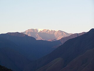
Ulla Qhaya, Jila Khayo, Huelancalloc, Huellancalloc or Pupuya is a 5,617-metre-high (18,428 ft) mountain in the Apolobamba mountain range in Bolivia. It is situated in the La Paz Department at the border of the Bautista Saavedra Province, Curva Municipality, and the Franz Tamayo Province, Pelechuco Municipality. Ulla Qhaya lies east of the lake Ch'uxña Quta and north-west of the mountain Iskillani.
Ch'uxña Quta is a 4,907-metre-high (16,099 ft) mountain in the Andes of Bolivia. It is situated in the La Paz Department, Larecaja Province, Sorata Municipality. Ch'uxña Quta lies in the northern extensions of the Cordillera Real southeast of the mountains Ch'uch'u and Ch'uch'u Apachita and northwest of Llawi Imaña.
K'usilluni is a mountain in the eastern extensions of the Apolobamba mountain range in Bolivia, about 4,600 metres (15,092 ft) high. It is situated in the La Paz Department, Bautista Saavedra Province, Curva Municipality. K'usilluni lies northeast of the mountain Qutañani.
Qillwa Quta is a mountain in the eastern extensions of the Apolobamba mountain range in Bolivia, about 4,900 metres (16,076 ft) high. It is situated in the La Paz Department, Bautista Saavedra Province, Curva Municipality.