Apolo is a location in the Franz Tamayo Province in the La Paz Department, Bolivia, South America, with a population of 2,123 in the year 2001. It is the seat of the Apolo Municipality.

Cobija is a city in Bolivia, capital of the department of Pando, and is located about 600 km (373 mi.) north of La Paz in the Amazon Basin on the border with Brazil. Cobija lies on the banks of the Rio Acre across from the Brazilian city of Brasiléia. Cobija lies at an elevation of ca. 280 m (920 ft.) above sea level and has a tropical and rainy climate.
Sorata is a small town in the La Paz Department in the Bolivian Andes, northwest of the city of La Paz and east of Lake Titicaca. It is the seat of the Larecaja Province and the Sorata Municipality. At the time of census 2001 it had a population of 2,217. It is a somewhat popular weekend getaway and a relaxing base camp for a growing number of hikers. It includes several small hotels, including a converted Italian mansion.

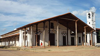
Omasuyos or Uma Suyu is a province in the La Paz Department in Bolivia. Its capital is Achacachi.
Inquisivi is the capital of the Inquisivi Province in the La Paz Department, Bolivia. It was officially named on November 2, 1844. Residents of Inquisivi are called Inquisivenos.

Mizque, Misk'i is a town in the Cochabamba Department, Bolivia. It is the capital of the Mizque Province. Mizque is located in the valley of the Mizque River, one of the main tributaries of the Río Grande.
Tupiza is a city in Potosí Department, Bolivia. It is located at an elevation of about 2850 m. The population is 25,709. Tupiza and its environs are characterized by dramatic red escarpments which jut ruggedly skyward from the coarse, gray terrain; green agricultural land adjacent to the nearby Tupiza River provides welcome respite from the otherwise arid, thorny surroundings. The area quebradas are susceptible to flash flood runoff from sudden cloudbursts.
Salinas de Garci Mendoza is a town in the Bolivian Oruro Department. It is the administrative center of Ladislao Cabrera Province and is located 280 km (170 mi) south-west of Oruro, the capital of the department. It is situated at an elevation of 3,732 m (12,244 ft) at Caricha, 20 km north of the Tunupa stratovolcano. Salar de Coipasa,a salt lake, is 20 km north-west of Salinas de Garci Mendoza, and 15 km in south-eastern direction is Salar de Uyuni, the world's largest salt pan. Salinas de Garci Mendoza is the endpoint of the road from Chuquichamba via Andamarca and Aroma to Salinas de Garci Mendoza.
San Ignacio de Moxos is a town in the Beni Department of northern Bolivia.
Viacha is a city in Bolivia, situated in the Ingavi Province in the La Paz Department. Viacha lies in the Altiplano, 22 km southwest of La Paz. Transportation to and from the city includes cars, buses, and a train.
Batallas is a location in the La Paz Department in Bolivia. It is the seat of the Batallas Municipality, one of the four municipalities of the Los Andes Province.
Caquiaviri is a location in the La Paz Department in Bolivia. It is the seat of the Caquiaviri Municipality, the second municipal section of the Pacajes Province.
Coripata is a town in the La Paz Department, Bolivia.

Irupana is a location in the La Paz Department in Bolivia. It is the seat of the Irupana Municipality, the second municipal section of the Sud Yungas Province.
Luribay is a location in the La Paz Department in Bolivia. It is the seat of the Luribay Municipality, the first municipal section of the José Ramón Loayza Province, and of the province.

Puerto Acosta or Waychu (Aymara) is a town in the La Paz Department, Bolivia.
Carangas (Oruro) is a small village in Bolivia. In 2010 it had an estimated population of 47.

Curahuara de Carangas is a small town in the Bolivian Oruro Department. It is the seat of the Sajama Province. In 2009 it had an estimated population of 1,581.
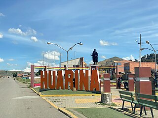
Huarina is a location in the La Paz Department in Bolivia. It is the seat of the Huarina Municipality, one of the four municipalities of the Omasuyos Province. President of Peru Andrés de Santa Cruz was born here.

Vitichi is a location in the Potosí Department in Bolivia. It is the capital of the Vitichi Municipality, the second municipal section of the Nor Chichas Province.