Omasuyos Province

Last updated
Omasuyos

Uma Suyu
Province
Titicacabolivia.JPG
Bolivia La Paz Omasuyos.png
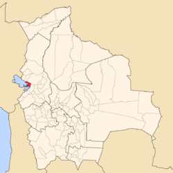
Location of Omasuyos Province within Bolivia
Bolivia Departamento La Paz.png
Provinces of the La Paz Department
Coordinates: 16°3′0″S68°38′0″W / 16.05000°S 68.63333°W / -16.05000; -68.63333
Country Flag of Bolivia.svg Bolivia
Department La Paz Department
Municipalities 4
Capital Achacachi
Area
  Total2,065 km2 (797 sq mi)
Population
 (2012 census)
  Total84,484
  Density41/km2 (110/sq mi)
  Ethnicities
Aymara
Time zone UTC-4 (BOT)
Area code(s) BO.LP.FT
Website Official website

Omasuyos (Hispanicized spelling) or Uma Suyu [1] (Aymara uma water, suyu region, "water region") [2] is a province in the La Paz Department in Bolivia. Its capital is Achacachi (Jach'a Q'achi).

Contents

The province is situated in the Altiplano bordered to the north by the Muñecas Province, to the northeast by the Larecaja Province, to the southeast by the Los Andes Province, to the south and west by Lake Titicaca and to the northwest by the Eliodoro Camacho Province.

Geography

The Cordillera Real traverses the province. Some of the highest mountains of the province are listed below: [3] [4] [5]

Subdivision

The province is divided into six municipalities. [6] [7]

MunicipalityInhabitants (2001) [8] Inhabitants

(2012) [9]

SeatInhabitants (2001)
Achacachi 70,50346,058 Achacachi 7,540
Huarina (included in Achacachi in 2001)7,948 Huarina 1,308
Santiago de Huata 8,562 Santiago de Huata 576
Huatajata 3,927 Huatajata 576
Chua Cocani 5,003 Chua Cocani 852
Ancoraimes 15,19913,136 Ancoraimes 561

° including separated cantons

Huarina and Santiago de Huata, and Huatajata and Chua Cocani received the status of municipalities in 2005, 2009, and 2010, respectively. Formerly they were cantons of the Achacachi Municipality.

See also

Related Research Articles

Ingavi Province Province in La Paz Department, Bolivia

Ingavi is a province in the La Paz Department in Bolivia. This is where the Battle of Ingavi occurred on November 18, 1841 and where the World Heritage Site of Tiwanaku is situated.

Larecaja Province Province in La Paz Department, Bolivia

Larecaja is a province in the Bolivian La Paz Department. It was founded by Antonio José de Sucre on October 18, 1826. Its capital is Sorata.

Loayza Province Province in La Paz Department, Bolivia

Loayza or José Ramón Loayza is a province in the La Paz Department, Bolivia. Its seat is Luribay.

Los Andes Province (Bolivia) Province in La Paz Department, Bolivia

Los Andes is one of the twenty provinces in the central parts of the Bolivian La Paz Department. The province was legally founded on November 24, 1917, during the presidency of José Gutiérrez Guerra. The Spanish name of the province means "The Andes", referring to its position within the Cordillera Real which is part of the Bolivian Andes mountain range. The capital of the province is Pucarani, which has a population of 918 as of the 2001 census. Pucarani is situated in the Altiplano west of the Cordillera Real offering a view of some of its highest mountains such as Ch'iyar Juqhu, Chachakumani, Kunturiri, Wayna Potosí and Chacaltaya.

Pedro Domingo Murillo Province Province in La Paz Department, Bolivia

Pedro Domingo Murillo is a province in the Bolivian La Paz Department. It was created on January 8, 1838, with the name Cercado and on October 17, 1912, during the presidency of Eliodoro Villazón, its name was changed in honor of Pedro Domingo Murillo, protagonist of the revolution of June 16, 1809.

Sorata Municipality Municipality in La Paz Department, Bolivia

Sorata Municipality is the first municipal section of the Larecaja Province in the La Paz Department, Bolivia. Its capital is Sorata. The Illampu - Janq'u Uma massif is located within the municipality, site of the 17th highest lake in the world, Laguna Glaciar.

Batallas Municipality is the third municipal section of the Los Andes Province in the La Paz Department, Bolivia. Its capital is Batallas.

Ancoraimes Municipality Municipality in La Paz Department, Bolivia

Ancoraimes or Janq'u Laymi (Aymara) is the second municipal section of the Omasuyos Province in the La Paz Department, Bolivia. Its seat is Ancoraimes.

Calacoto Municipality Municipality in La Paz Department, Bolivia

Calacoto or Qala Qutu is the third municipal section of the Pacajes Province in the La Paz Department, Bolivia. Its seat is Calacoto.

Luribay Municipality Municipality in La Paz Department, Bolivia

Luribay Municipality is the first municipal section of the Loayza Province in the La Paz Department, Bolivia. Its seat is Luribay.

Malla Municipality is the fourth municipal section of the Loayza Province in the La Paz Department, Bolivia. Its seat is Malla.

Jacha Jawira (Los Andes)

Jach'a Jawira which downstream is named Japha Jawira is a Bolivian river east of Lake Titicaca in the La Paz Department, Los Andes Province, Batallas Municipality and in the Omasuyos Province, Achacachi Municipality. Its waters flow to Lake Titicaca via the Qiqa Jawira.

Chilla-Kimsa Chata mountain range

The Chilla-Kimsa Chata mountain range is situated in Bolivia south east of Wiñaymarka Lake, the southern part of Lake Titicaca, in the La Paz Department, Ingavi Province. The range is named after one of highest mountains, the Kimsa Chata complex rising up to 4,735 metres (15,535 ft) about 15 km south of Tiwanaku.

Jacha Qullu (Los Andes)

Jach'a Qullu is a 5,298-metre-high (17,382 ft) mountain in the Cordillera Real in the Andes of Bolivia. It lies in the La Paz Department, Los Andes Province, Batallas Municipality. Jach'a Qullu is situated southwest of Jisk'a Pata and Jach'a Pata, southwest of Jach'a Juqhu and northwest of Wila Lluxi, Warawarani and Qala T'uxu.

Wari Qalluni Pata

Wari Qalluni Pata is a 5,064-metre-high (16,614 ft) mountain in the Cordillera Real in the Andes of Bolivia. It is situated in the La Paz Department, Larecaja Province, Guanay Municipality, and in the Omasuyos Province, Achacachi Municipality, west of the mountain Ch'iyar Juqhu.

Qara Qullu

Q'ara Qullu is a 4,956-metre-high (16,260 ft) mountain in the Andes of Bolivia. It is situated in the La Paz Department, Omasuyos Province, Achacachi Municipality. Q'ara Qullu lies south of Janq'u Uma and Janq'u K'ark'a of the Cordillera Real. San Francisco Lake is at its feet, east of it.

Janqu Karka (Larecaja-Omasuyos)

Janq'u K'ark'a is a mountain in the Cordillera Real in the Andes of Bolivia, about 5,200 metres (17,060 ft) high. It is situated in the La Paz Department, Larecaja Province, Sorata Municipality, and in the Omasuyos Province, Achacachi Municipality. Janq'u K'ark'a lies south of the Janq'u Uma-Illampu massif, southeast of the mountain Quña Quñani and the lakes Warawarani (Huara Huarani) and Jisk'a Warawarani (Jiskha Huara Huarani).

Jach'a Jawira which later is named Q'ara Qullu and Waña Jawira is a Bolivian river in the La Paz Department and in the Oruro Department. Its waters flow towards Uru Uru Lake.

Piqiñ Qullu

P'iq'iñ Qullu is a mountain in the north of the Cordillera Real in the Andes of Bolivia, about 4,875-metre (15,994 ft) high. It is situated in the La Paz Department, Larecaja Province, Sorata Municipality. P'iq'iñ Qullu lies west of the Janq'u Uma-Illampu massif southeast of Sorata.

The Llallawa Jawira which upstream successively is named Patu Uma, Ch'alla Jawira, Jach'a Qura, Lupipi and Chuqi Phuju is a river in the La Paz Department in Bolivia. It is a left tributary of the Desaguadero River.

References

  1. Yaticha Kamani / Ministerio de Educación, Aymara aru thakhinchawi, Chuqi Yapu 2011
  2. Radio San Gabriel, "Instituto Radiofonico de Promoción Aymara" (IRPA) 1993, Republicado por Instituto de las Lenguas y Literaturas Andinas-Amazónicas (ILLLA-A) 2011, Transcripción del Vocabulario de la Lengua Aymara, P. Ludovico Bertonio 1612 (Spanish-Aymara-Aymara-Spanish dictionary)
  3. Bolivian IGM map 1:50,000 5846-III Ancoraimes
  4. Bolivian IGM map 1:50,000 5846-IV Mina Matilde
  5. "Ancoraimes". INE, Bolivia. Archived from the original on February 15, 2016. Retrieved February 10, 2016. labelled (Khara Kella)
  6. www.bolivia.com (Spanish)
  7. www.planguarani.com Archived 2011-07-15 at the Wayback Machine (Spanish)
  8. National Institute of Statistics of Bolivia Archived 2009-10-27 at the Wayback Machine (Spanish)
  9. Instituto Nacional de Estadística. "Ficha Resúmen Censo de Poblacion y Vivienda 2012" . Retrieved 19 September 2017.

Commons-logo.svg Media related to Omasuyos Province at Wikimedia Commons

Coordinates: 16°03′S68°38′W / 16.050°S 68.633°W / -16.050; -68.633