Eliodoro Camacho | |
---|---|
Province | |
![]() Suches River in Umanata | |
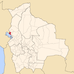
![]() Location of Eliodoro Camacho Province within Bolivia | |
![]() Provinces of the La Paz Department | |
Coordinates: 15°30′0″S69°5′0″W / 15.50000°S 69.08333°W | |
Country | ![]() |
Department | La Paz Department |
Municipalities | 5 |
Foundation | November 5, 1908 |
Capital | Puerto Acosta |
Area | |
• Total | 2,080 km2 (800 sq mi) |
Population (2024 census) [1] | |
• Total | 63,266 |
• Density | 30/km2 (79/sq mi) |
• Ethnicities | Aymara |
Time zone | UTC-4 (BOT) |
Website | Official website |
Eliodoro Camacho is a province in the La Paz Department in Bolivia situated at Lake Titicaca. Its seat is Puerto Acosta.
Camacho Province is situated in the western region of the La Paz Department bordered to the north by the Muñecas Province, to the east by the Larecaja Province, to the south by the Omasuyos Province, to the west by Lake Titicaca and Moho Province located in the Puno Region of Peru.
Camacho Province was created during the presidency of General Ismael Montes on November 5, 1908, [2] named after the Bolivian politician and officer Eliodoro Camacho. Originally it was composed of the cantons Huaycho, Escoma, Carabuco, Italaque, Mocomoco and Ambaná. Huaycho became the capital of the province under the name "Puerto Acosta" (meaning: "Port Acosta") in honor of the writer Nicolás Acosta (1844 - 1893). [3]
The province is divided into five municipalities [4] which are further subdivided into cantons.
Section | Municipality | Seat | Inhabitants (2001) [5] |
---|---|---|---|
1st | Puerto Acosta Municipality | Puerto Acosta | 1,123 |
2nd | Mocomoco Municipality | Mocomoco | 444 |
3rd | Puerto Carabuco Municipality | Puerto Carabuco | 416 |
4th | Umanata Municipality (also Humanata Municipality) | Umanata (also Humanata) | 192 |
5th | Escoma Municipality | Escoma | 576 |
The Bolivian Armed Forces are the military of Bolivia. The Armed Forces of Bolivia are responsible for the defence, both of external and internal, of Bolivia and they are constituted by Bolivian Army, the Bolivian Air Force and the Bolivian Navy. All these institutions depend on the Ministry of Defence of this country.
The La Paz Department of Bolivia comprises 133,985 square kilometres (51,732 sq mi) with a 2024 census population of 3,022,566 inhabitants. It is situated at the western border of Bolivia, sharing Lake Titicaca with the neighboring Peru. It contains the Cordillera Real mountain range, which reaches altitudes of 6.6 kilometers (22,000 ft). Northeast of the Cordillera Real are the Yungas, the steep eastern slopes of the Andes Mountains that make the transition to the Amazon River basin to the northeast. The capital of the department is the city of La Paz and is the administrative city and seat of government/national capital of Bolivia.
Aroma is one of the twenty provinces of the Bolivian La Paz Department. It is situated in the southern parts of the department. Its seat is Sica Sica.
Bautista Saavedra is one of the twenty provinces of the Bolivian La Paz Department situated in the northwestern parts of the department. It was created on November 17, 1948 in honor of Bautista Saavedra Mallea (1870-1939) who was Bolivia's president from 1920 to 1925. The capital of the province is Charazani.
Caranavi Province is one of the twenty provinces of the Bolivian La Paz Department and is situated in the department's eastern parts. The province was created by Law 1401 on 16 December 1992 from a portion of what was then Nor Yungas Province. The creation of the province had been a local cause embraced by Ramiro Revuelta, a Deputy in the national legislature who was assassinated on November 28, 1992.
Ingavi is a province in the La Paz Department in Bolivia. This is where the Battle of Ingavi occurred on November 18, 1841, and where the World Heritage Site of Tiwanaku is situated.
José Manuel Pando is a province in the La Paz Department in Bolivia. It was founded on April 22, 1986, during the presidency of Víctor Paz Estenssoro. The province was named after José Manuel Pando (1848–1917) who was the president of Bolivia from 1899 till 1904. Its capital is Santiago de Machaca.
Omasuyos or Uma Suyu is a province in the La Paz Department in Bolivia. Its capital is Achacachi.
Pedro Domingo Murillo is a province in the Bolivian La Paz Department. It was created on January 8, 1838, with the name Cercado and on October 17, 1912, during the presidency of Eliodoro Villazón, its name was changed in honor of Pedro Domingo Murillo, protagonist of the revolution of June 16, 1809.
Achacachi is a town on the Altiplano plateau in the South American Andes in the La Paz Department in Bolivia. It is the capital of the Omasuyos Province.
Yampupata is a Bolivian peninsula of Lake Titicaca situated in the north-western part of the Copacabana Peninsula in the La Paz Department, Manco Kapac Province, Copacabana Municipality, Zampaya Canton. It is located near the islands Isla de la Luna and Isla del Sol forming the Strait of Yampupata together with the latter one.
Achacachi Municipality is one of six municipalities of the Omasuyos Province in the La Paz Department in Bolivia. Its seat is Achacachi.
Puerto Acosta Municipality is the first municipal section of the Eliodoro Camacho Province in the La Paz Department in Bolivia. Its seat is Puerto Acosta. At the time of census 2001 the municipality had a population of 27,296, still including Umanata and Escoma as cantons.
Puerto Carabuco Municipality is the third municipal section of the Eliodoro Camacho Province in the La Paz Department, Bolivia. Its seat is Puerto Carabuco.
Inquisivi Municipality is the first municipal section of the Inquisivi Province in the La Paz Department in Bolivia. Its seat is Inquisivi.
Achiri is a location in the La Paz Department in Bolivia. In 2010 it had an estimated population of 817.
Escoma is a location in the La Paz Department in Bolivia. It is the seat of the Escoma Municipality, one of five municipalities of the Eliodoro Camacho Province. In 2009 Escoma had an estimated population of 712.
Villa Rosario de Wilacala is a village in the La Paz Department in Bolivia. It is the seat of the Villa Rosario de Wila Khala Canton, one of the five cantons of the Mocomoco Municipality which is the second municipal section of the Eliodoro Camacho Province. The village is situated 4,264 m high at the north-western edge of the Muñecas Mountain Range (Cordillera Muñecas) near the border to Peru. At the time of census 2001 it had a population of 303.
Umanata Municipality is the fourth municipal section of the Eliodoro Camacho Province in the La Paz Department in Bolivia. It was created on February 6, 2009. Until then it was one of the cantons of the Viacha Municipality. Its seat is Umanata with 196 inhabitants in 2001.
Escoma Municipality is the fifth municipal section of the Eliodoro Camacho Province in the La Paz Department in Bolivia. It was created on February 6, 2009. Until then this area was part of the Viacha Municipality. Its seat is Escoma with 576 inhabitants in the year 2001.
15°30′S69°05′W / 15.500°S 69.083°W