Inquisivi is a province in the La Paz Department in Bolivia. During the presidency of José Ballivián it was created on November 2, 1844. The capital of the province is Inquisivi.
José Manuel Pando is a province in the La Paz Department in Bolivia. It was founded on April 22, 1986, during the presidency of Víctor Paz Estenssoro. The province was named after José Manuel Pando (1848–1917) who was the president of Bolivia from 1899 till 1904. Its capital is Santiago de Machaca.

Loayza or José Ramón Loayza is a province in the La Paz Department, Bolivia. Its seat is Luribay.

Pedro Domingo Murillo is a province in the Bolivian La Paz Department. It was created on January 8, 1838, with the name Cercado and on October 17, 1912, during the presidency of Eliodoro Villazón, its name was changed in honor of Pedro Domingo Murillo, protagonist of the revolution of June 16, 1809.

Pacajes is a province in the Bolivian department of La Paz. Its capital is Coro Coro.

Turco Municipality is the second municipal section of the Sajama Province in the Oruro Department in Bolivia, and was founded on February 15, 1957. Its seat is Turco, situated 154 km west of Oruro at an altitude of 3,860 m. The municipality covers an area of 3,973 km², not taking into account the area of Laca Laca Canton.
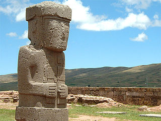
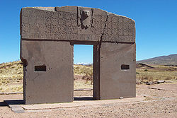
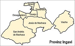
Tiwanaku Municipality is the third municipal section of the Ingavi Province in the La Paz Department, Bolivia. Its seat is the village of Tiwanaku located near the UNESCO World Heritage Site Tiwanaku.

Jesús de Machaca Municipality is the sixth municipal section of the Ingavi Province in the La Paz Department in Bolivia. It was created by Law No. 2351 on May 7, 2002, during the presidency of Jorge Quiroga Ramírez. Its seat is Jesús de Machaca.
Calacoto or Qala Qutu is the third municipal section of the Pacajes Province in the La Paz Department, Bolivia. Its seat is Calacoto.
Malla Municipality is the fourth municipal section of the Loayza Province in the La Paz Department, Bolivia. Its seat is Malla.
The Jach'a Jawira is a river in the La Paz Department of Bolivia, south of Wiñaymarka, the southern branch of Lake Titicaca. It is a tributary of the Desaguadero River.
Katari River which upstream successively is named Jach'a Jawira, Colorado, Mani and then Colorado again is a river in the La Paz Department of Bolivia, about 90 km long, southeast of Lake Titicaca. It empties into Wiñaymarka Lake, the southern part of Lake Titicaca.

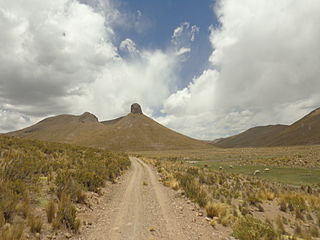
The Chilla-Kimsa Chata mountain range is situated in Bolivia south east of Wiñaymarka Lake, the southern part of Lake Titicaca, in the La Paz Department, Ingavi Province. The range is named after one of highest mountains, the Kimsa Chata complex rising up to 4,735 metres (15,535 ft) about 15 km south of Tiwanaku.
Chuqi Ch'iwani is a 4,695-metre-high (15,404 ft) mountain in the Chilla-Kimsa Chata mountain range in the Andes of Bolivia. It lies south-east of Wiñaymarka Lake, the southern part of Lake Titicaca. It is located in the La Paz Department, Ingavi Province, at the border of the Jesús de Machaca Municipality and the Tiwanaku Municipality. Chuqi Ch'iwani is situated south of the mountains Nasa Puqi and Kimsa Chata.
Chuqi Q'awa is a 4,790-metre-high (15,715 ft) mountain in the Chilla-Kimsa Chata mountain range in the Andes of Bolivia. It lies in the La Paz Department, Ingavi Province, Jesús de Machaca Municipality. Chuqi Q'awa is situated west of the mountain Pukara.
Chuqi Q'awa is a 4,570-metre-high (14,993 ft) mountain in the Chilla-Kimsa Chata mountain range in the Andes of Bolivia. It lies in the La Paz Department, Ingavi Province, in the north of the Jesús de Machaca Municipality, near the border with the Tiwanaku Municipality. Chuqi Q'awa is situated south of the river Chuñuni Jawira (Chununi Jahuira).
Chhuxlla Willk'i is a 4,664-metre-high (15,302 ft) mountain in the Chilla-Kimsa Chata mountain range in the Andes of Bolivia. It lies in the La Paz Department, Ingavi Province, Jesús de Machaca Municipality. Chhuxlla Willk'i is situated south-east of the 4,737-metre-high (15,541 ft) mountain named Qala Cruz (Khala Cruz) and Ch'alla Qullu, and north-east of a 4,522-metre-high (14,836 ft) mountain which is also called Qala Cruz.
Ch'alla Qullu is a mountain in the Chilla-Kimsa Chata mountain range in the Andes of Bolivia which reaches a height of about 4,660 m (15,290 ft). It is located in the La Paz Department, Ingavi Province, Jesús de Machaca Municipality. Ch'alla Qullu lies northwest of Chhuxlla Willk'i. The Ch'uñu Jawira originates near the mountain. It flows to the south as a right affluent of the Jach'a Jawira.
Wila Qullu is a mountain in the Chilla-Kimsa Chata mountain range in the Andes of Bolivia which reaches a height of approximately 4,400 m (14,400 ft). It is located in the La Paz Department, Ingavi Province, on the border of the municipalities of Jesús de Machaca and Tiwanaku. Wila Qullu lies north of Chuqi Q'awa.
The Llallawa Jawira which upstream successively is named Patu Uma, Ch'alla Jawira, Jach'a Qura, Lupipi and Chuqi Phuju is a river in the La Paz Department in Bolivia. It is a left tributary of the Desaguadero River.