Sorata

Last updated
Sorata
Sorata, Bolivia.jpg
Panoramic view of Sorata
Bolivia adm location map.svg
Red pog.svg
Sorata
Location within Bolivia
Coordinates: 15°46′S68°38′W / 15.767°S 68.633°W / -15.767; -68.633
Country Flag of Bolivia.svg Bolivia
Department Flag of La paz.svg La Paz Department
Province Larecaja Province
Municipality Sorata Municipality
Canton Sorata Canton
Elevation
8,786 ft (2,678 m)
Population
 (2029)
  Total2,217
Time zone UTC-4 (BOT)

Sorata (Aymara: Surat'a) is a small town in the La Paz Department in the Bolivian Andes, northwest of the city of La Paz and east of Lake Titicaca. It is the seat of the Larecaja Province and the Sorata Municipality. At the time of census 2001 it had a population of 2,217. [1] It is a somewhat popular weekend getaway and a relaxing base camp for a growing number of hikers. It includes several small hotels, including a converted Italian mansion.

Contents

History

In colonial days, Sorata provided a link to the Alto Beni goldfields and rubber plantations, and a gateway to the Amazon Basin. In August 1781 it was the site of an unorthodox siege by the nephew of Tupac Amaru, Andres, and his 16,000 soldiers. They constructed dikes above the town, and when these had been filled with runoff from the slopes of the nearby peak Illampu, they opened the floodgates and the town was washed away. [2] [3] The citizens of Sorata have, in recent history, violently opposed what they see as the rule of a too centralised government. For example, in the summer of 2005, the town was blockaded and inaccessible for several days in response to the government's plans to privatise Bolivia'a oil reserves.[ citation needed ] It is said that during world war 2, many immigrants from the war came to this city.

Cityscape

Sorata2.jpg

Sorata is no longer a major commercial center, as there is now a more direct route to the Yungas from La Paz. Today it is best known to foreign tourists, trekkers, and climbers, who visit this formerly little-known destination. The main square, Plaza General Enrique Penaranda, is Sorata's showcase. It is graced by towering date palms and immaculate gardens. The main town fiesta is held on September 14. Of note is Casa Gunthere, a historic mansion that now houses the Residencial Sorata. It was built in 1895 as the home of the Richters, a quinine trading family.

Sorata1.jpg

Sorata is located at the base of the mountains Illampu, 6,368 m (20,892 ft), and Janq'u Uma, 6,427 m (21,086 ft), which are the northern anchors of the Cordillera Real. By the most reliable figures, Janq'u Uma is 11 m (36 ft) lower than Illimani, near La Paz, but surveys in the area are imperfect, and there is much debate between the citizens of both areas as to which mountain is higher.


Climate

Sorata features an unusual subtropical highland climate, with oceanic elements and high levels of diurnal temperature variation.

Climate data for Sorata, elevation 2,647 m (8,684 ft)
MonthJanFebMarAprMayJunJulAugSepOctNovDecYear
Mean daily maximum °C (°F)21.3
(70.3)
20.8
(69.4)
21.1
(70.0)
21.4
(70.5)
20.9
(69.6)
20.4
(68.7)
20.1
(68.2)
21.3
(70.3)
22.2
(72.0)
23.0
(73.4)
22.9
(73.2)
22.2
(72.0)
21.5
(70.6)
Daily mean °C (°F)15.7
(60.3)
15.6
(60.1)
15.4
(59.7)
15.3
(59.5)
14.4
(57.9)
13.7
(56.7)
13.4
(56.1)
14.5
(58.1)
15.4
(59.7)
16.2
(61.2)
16.4
(61.5)
16.0
(60.8)
15.2
(59.3)
Mean daily minimum °C (°F)10.1
(50.2)
10.3
(50.5)
9.8
(49.6)
9.2
(48.6)
8.0
(46.4)
7.0
(44.6)
6.7
(44.1)
7.8
(46.0)
8.7
(47.7)
9.4
(48.9)
9.9
(49.8)
9.9
(49.8)
8.9
(48.0)
Average precipitation mm (inches)178.4
(7.02)
160.5
(6.32)
142.1
(5.59)
53.2
(2.09)
19.2
(0.76)
8.0
(0.31)
6.2
(0.24)
14.7
(0.58)
34.1
(1.34)
53.7
(2.11)
63.6
(2.50)
116.9
(4.60)
850.6
(33.46)
Average precipitation days20.518.818.89.04.22.32.53.66.38.69.715.9120.2
Average relative humidity (%)84.184.984.381.677.673.475.275.075.976.778.081.079.0
Source: Servicio Nacional de Meteorología e Hidrología de Bolivia [4] [5]

Related Research Articles

Apolo is a location in the Franz Tamayo Province in the La Paz Department, Bolivia, South America, with a population of 2,123 in the year 2001. It is the seat of the Apolo Municipality.

<span class="mw-page-title-main">Larecaja Province</span> Province in La Paz Department, Bolivia

Larecaja is a province in the Bolivian La Paz Department. It was founded by Antonio José de Sucre on October 18, 1826. Its capital is Sorata.

<span class="mw-page-title-main">Achacachi</span> Place in La Paz Department, Bolivia

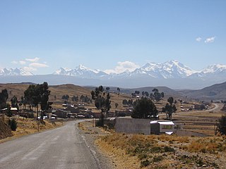
Achacachi is a town on the Altiplano plateau in the South American Andes in the La Paz Department in Bolivia. It is the capital of the Omasuyos Province.

<span class="mw-page-title-main">Illampu</span> Mountain in Bolivia

Illampu is the fourth highest mountain in Bolivia. It is located in the northern section of the Cordillera Real, part of the Andes, east of Lake Titicaca. It lies just north of the slightly higher Janq'u Uma, near the town of Sorata. Laguna Glaciar, located in the Illampu-Janq'u Uma massif, is the 17th highest lake in the world.

<span class="mw-page-title-main">Ancohuma</span> Mountain in Bolivia

Ancohuma or Janq'u Uma is the third highest mountain in Bolivia. It is located in the northern section of the Cordillera Real, part of the Andes, east of Lake Titicaca. It lies just south of the slightly lower Illampu, near the town of Sorata.

<span class="mw-page-title-main">Sorata Municipality</span> Municipality in La Paz Department, Bolivia

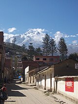
Sorata Municipality is the first municipal section of the Larecaja Province in the La Paz Department, Bolivia. Its capital is Sorata. The Illampu - Janq'u Uma massif is located within the municipality, site of the 17th highest lake in the world, Laguna Glaciar.

Coripata is a town in the La Paz Department, Bolivia.

<span class="mw-page-title-main">Huarina</span> Town in La Paz Department, Bolivia

Huarina is a location in the La Paz Department in Bolivia. It is the seat of the Huarina Municipality, one of the four municipalities of the Omasuyos Province. President of Peru Andrés de Santa Cruz was born here.

<span class="mw-page-title-main">Q'asiri (Larecaja)</span> Mountain in Bolivia

Q'asiri is a mountain in the Cordillera Real in the Andes of Bolivia, about 5,828 m (19,121 ft) high. It is located in the La Paz Department, Larecaja Province, Sorata Municipality. It is situated south-east of the mountain Janq'u Uma, north-west of the mountains Qalsata and Ch'iyar Juqhu and north-east of San Francisco Lake.

Ch'iyar Qullu is a 4,875-metre-high (15,994 ft) mountain in the north of the Cordillera Real in the Andes of Bolivia. It is situated in the La Paz Department, Larecaja Province, Sorata Municipality. Ch'iyar Qullu lies west of the Janq'u Uma-Illampu massif and north-east of the mountain Achachi Qullu (Achachi Kkollu).

<span class="mw-page-title-main">Jach'a Pukara</span> Mountain in Bolivia

Jach'a Pukara is a mountain in the Andes of Bolivia, about 4,300 metres (14,108 ft) high. It is situated in the La Paz Department, Larecaja Province, Sorata Municipality. Jach'a Pukara lies between Lake Titicaca in the west and the Janq'u Uma-Illampu massif of the Cordillera Real in the east.

Wiluyu Janq'u Uma or Wiluyu is a mountain in the Cordillera Real in the Andes of Bolivia, about 5,540 metres (18,176 ft) high. It is located in the La Paz Department, Larecaja Province, Sorata Municipality. It lies northwest of the mountain Yapuchañani, northeast of Misk'i T'ant'a and Uma Jalanta and east of Illampu.

Janq'u K'ark'a is a mountain in the Cordillera Real in the Andes of Bolivia, about 5,200 metres (17,060 ft) high. It is situated in the La Paz Department, Larecaja Province, Sorata Municipality, and in the Omasuyos Province, Achacachi Municipality. Janq'u K'ark'a lies south of the Janq'u Uma-Illampu massif, southeast of the mountain Quña Quñani and the lakes Warawarani (Huara Huarani) and Jisk'a Warawarani (Jiskha Huara Huarani).

Wila Quta is a mountain in the Andes of Bolivia, about 4,960 metres (16,273 ft) high. It is situated in the La Paz Department, Larecaja Province, Sorata Municipality, north of the massif of Janq'u Uma and Illampu of the Cordillera Real. The river Janq'u Uma Jawira originates south of the mountain. It flows to the north-east.

Ch'uch'u Jawira is a Bolivian river in the La Paz Department, Larecaja Province, Sorata Municipality. Its waters flow the Kaka River which belongs to the watershed of the Beni River.

P'iq'iñ Qullu is a mountain in the north of the Cordillera Real in the Andes of Bolivia, about 4,875-metre (15,994 ft) high. It is situated in the La Paz Department, Larecaja Province, Sorata Municipality. P'iq'iñ Qullu lies west of the Janq'u Uma-Illampu massif southeast of Sorata.

Jach'a Apachita is a mountain in the Andes of Bolivia, about 4,420 metres (14,501 ft) high. It is situated in the La Paz Department, Larecaja Province, Sorata Municipality. Jach'a Apachita lies northeast of the Janq'u Uma-Illampu massif of the Cordillera Real.

Ch'uxñani is a 4,680-metre-high (15,354 ft) mountain in the Andes of Bolivia. It is located in the La Paz Department, Larecaja Province, Sorata Municipality, in the northern extensions of the Cordillera Real southeast of the mountain Jach'a Waylla Punta. Ch'uxñani lies near the confluence of the rivers Ch'uch'u Jawira which comes from the northwest and Jach'a Uma Jawira which originates between the mountain Wila Quta and the Janq'u Uma-Illampu massif.

Qala Phusa is a 4,884-metre-high (16,024 ft) mountain in the Andes of Bolivia. It is situated in the La Paz Department, Larecaja Province, Sorata Municipality. Qala Phusa lies north of the Janq'u Uma-Illampu massif of the Cordillera Real, northwest of the mountain Wila Quta and southeast of Llawi Imaña.

Quña Quñani is a 5,006-metre-high (16,424 ft) mountain in the north of the Cordillera Real in the Andes of Bolivia. It is located in the La Paz Department, Larecaja Province, Sorata Municipality. Quña Quñani lies south of the Janq'u Uma-Illampu massif between the lakes Laram Quta in the northwest and Warawarani (Huara Huarani) and Jisk'a Warawarani (Jiskha Huara Huarani) in the east and southeast. It is situated north and northwest of the mountains Salluyu (Salluyo) and Janq'u K'ark'a.

References

  1. World-Gazetteer [ dead link ]
  2. Deanna Swaney, Robert Strauss, Bolivia (Second Edition), Lonely Planet, 1992.
  3. The siege is mentioned in Herbert S. Klein, Bolivia: the evolution of a multi-ethnic society (second edition), Oxford, 1992; however that book makes no mention of the tactic of flooding the town.
  4. "Base de datos Sistema Meteorológico–SISMET" (in Spanish). Servicio Nacional de Meteorología e Hidrología de Bolivia. Archived from the original on 7 June 2018. Retrieved 13 June 2024.
  5. "índices climáticos para 149 estaciones meteorológicas en Bolivia" (in Spanish). Servicio Nacional de Meteorología e Hidrología de Bolivia. Retrieved 13 June 2024.

15°46′24″S68°38′53″W / 15.77333°S 68.64806°W / -15.77333; -68.64806