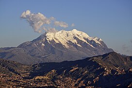
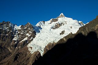
Illimani (Aymara and Spanish pronunciation:[iʎiˈmani]) is the highest mountain in the Cordillera Real (part of the Cordillera Oriental, a subrange of the Andes) of western Bolivia. It lies near the cities of El Alto and La Paz at the eastern edge of the Altiplano. It is the second highest peak in Bolivia, after Nevado Sajama, and the eighteenth highest peak in South America.[3] The snow line lies at about 4,570 metres (15,000ft) above sea level, and glaciers are found on the northern face at 4,982m (16,350ft). The mountain has four main peaks; the highest is the south summit, Nevado Illimani, which is a popular ascent for mountain climbers.
Illimani is quite visible from the cities of El Alto and La Paz, and is their major landmark. The mountain has been the subject of many local songs, most importantly "Illimani", with the following refrain: "¡Illimani, Illimani, centinela tú eres de La Paz! ¡Illimani, Illimani, perla andina eres de Bolivia!" ("Illimani, Illimani, you are the sentinel of La Paz! Illimani, Illimani, you are Bolivia's andean pearl!")
Climbing
Illimani has become a symbol of La Paz, Bolivia's seat of government.
Illimani was first attempted in 1877 by the French explorator Charles Wiener, J. de Grumkow, and J. C. Ocampo. They failed to reach the main summit, but did reach a southeastern subsummit, on 19 May 1877, Wiener named it the "Pic de Paris", and left a French flag on top of it.[5] In 1898, British climber William Martin Conway and two Italian guides, J.A. Maquignaz and L. Pellissier, made the first recorded ascent of the peak, again from the southeast. (They found a piece of Aymara rope at over 6,000m (20,000ft), so an earlier ascent cannot be completely discounted[6]).
The current standard route on the mountain climbs the west ridge of the main summit. It was first climbed in 1940, by the Germans R. Boetcher, F. Fritz, and W. Kühn, and is graded French PD+/AD-.[6] This route usually requires four days, the summit being reached in the morning of the third day.
In July 2010 German climber Florian Hill and long-time Bolivian resident Robert Rauch climbed a new route on the 'South Face', completing most of the 1700m of ascent in 21 hours. Deliver Me (WI 6 and M6+) appears to climb the gable-end of the South West Ridge, a very steep wall threatened by large broken seracs.[7]
Incidents
In 1973 Pierre Dedieu, French, and Ernesto Sánchez, Bolivia's best climber, perished climbing Illimani in August. In November an Italian expedition after ascending Illimani undertook the search for their bodies, locating the body of Sánchez, but on the 23rd of that month, during extended search for Dedieu, the Italian leader Carlo Nembrini fell to his death.[8]
US Major Kenneth R. Miller, US Colonel Paul Bruce Kappelman, and Bolivian guide Vincente Perez died in a climbing accident on June 7, 2003.[9]
A German climber died on May 2, 2017, due to an avalanche occurring during the evening as he and his guide were climbing.[10] The guide survived with minor injuries.
American climber Daniel Granberg died on the summit of Illimani in September 2021. His body was recovered after a two-day effort.[11]
↑ This is sometimes given as 6,462 m, but topographic map sources, including a very accurate map by the German Alpine Club, agree that it is 6,438 m. This figure comes from a differential GPS survey; see the reference to World Mountaineering.
↑ Yossi Brain, Bolivia: a climbing guide, The Mountaineers, 1999, ISBN0-89886-495-X. Some sources claim that Illimani is an extinct stratovolcano, but this is not correct. In fact none of the peaks of the Cordillera Real are volcanic; see Tom Simkin and Lee Siebert, Volcanoes of the World, a regional directory... (second edition), Smithsonian Institution/Geoscience Press, 1994, ISBN0-945005-12-1.
↑ René, Verneau (18 May 2018). "Charles Wiener". Journal de la société des américanistes. 11 (1).
1 2 Lindsay Griffin (1998). "Illimani". In Audrey Salkeld (ed.). World Mountaineering. Bulfinch Press. pp.254–257. ISBN0-8212-2502-2.
Aconcagua is a mountain in the Principal Cordillera of the Andes mountain range, in Mendoza Province, Argentina. It is the highest mountain in the Americas, the highest outside Asia, and the highest in both the Western Hemisphere and the Southern Hemisphere with a summit elevation of 6,961 metres (22,838 ft). Despite its impressive size and stature, it is only the 189th highest mountain in the world. It lies 112 kilometres northwest of the provincial capital, the city of Mendoza, about five kilometres from San Juan Province, and 15 km (9 mi) from Argentina's border with Chile. The mountain is one of the Seven Summits of the seven continents.
Alpamayo or Shuyturaju is one of the most conspicuous peaks in the Cordillera Blanca of the Peruvian Andes. Alpamayo Creek originates northwest of it.
Huascarán, Nevado Huascarán or Mataraju is a mountain located in Yungay Province, Department of Ancash, Peru. It is situated in the Cordillera Blanca range of the western Andes. The southern summit of Huascarán, which reaches 6,768 metres (22,205 ft), is the highest point in Peru, the northern Andes, and in all of the earth's Tropics. Huascarán is the 4th highest mountain in South America after Aconcagua, Ojos del Salado, and Monte Pissis. Huascarán is ranked 25th by topographic isolation.
Huayna Potosí is a mountain in Bolivia, located near El Alto and about 25 km north of La Paz in the Cordillera Real.
Ancohuma or Janq'u Uma is the third highest mountain in Bolivia. It is located in the northern section of the Cordillera Real, part of the Andes, east of Lake Titicaca. It lies just south of the slightly lower Illampu, near the town of Sorata.
Apolobamba(Cordillera Apolobamba) is a mountain range in the South American Andes.
Chachacomani is a mountain in the Cordillera Real of the Andes Mountains, east of Lake Titicaca in Bolivia.
Chearoco, Chiaraco or Chiaroco is a mountain in the Cordillera Real in the Andes of Bolivia. It has a height of about 6,127 m (20,102 ft). It is situated in the La Paz Department, Larecaja Province, Guanay Municipality, southeast of the peak of Aman Pata. Chearoco lies between Qalsata in the northwest and Chachakumani in the southeast.
Chaupi Orco or Viscachani is a mountain in the Andes on the border of Bolivia and Peru. It has a height of 6,044 metres (19,829 ft). On the Bolivian side it is located in the La Paz Department, Franz Tamayo Province, Pelechuco Municipality, and on the Peruvian side it lies in the Puno Region, Putina Province, Sina District. It lies north of Salluyu. Chaupi Orco is the highest peak of the Apolobamba mountain range.
Jachacunocollo, also known as Jacha Cuno Collo, Tres Marias, Don Luis or Jacha Collo is a mountain in the Andes in Bolivia. It is the highest elevation in the Quimsa Cruz Range reaching an elevation of about 5,800 metres (19,029 ft). Jachacunocollo is situated in the La Paz Department, Inquisivi Province, Quime Municipality, north-west of Wayna Khunu Qullu, the second highest mountain in this mountain range.
Wayna Khunu Qullu or Wayna Khunuqullu is one of the highest peaks in the Kimsa Cruz mountain range in the Andes of Bolivia. Its summit reaches about 5,640 metres (18,504 ft) above sea level.
Calzada is a mountain in the Andes, about 5,874 m (19,272 ft) high, located in the Cordillera Real of Bolivia. It lies in the La Paz Department, Larecaja Province, on the border of the Sorata Municipality and the Guanay Municipality. It is situated south-east of Ancohuma, between the mountain Q'asiri in the north-west and Chearoco in the south-east, and east of San Francisco Lake.
Chacraraju or Chakraraju is a mountain in the Cordillera Blanca range in the Andes of Peru. The mountain has two distinctive peaks: Chacraraju Oeste and Chacraraju Este. Chacraraju is located in Huaylas Province, Ancash; south and southeast of Pirámide and east of Lake Parón. The peak is accessible from the Pisco base camp at Cebollapampa.
Sahuasiray, Sawasiray,Colque Cruz or Ccolque Cruz, is one of the highest mountains in the Urubamba mountain range in the Andes of Peru, about 5,818 metres (19,088 ft) high. It lies in the Cusco Region, Calca Province, northwest of Calca. It is situated northeast of Chicón and Canchacanchajasa, southeast of Sirihuani and northwest of Condorhuachana.
Pucaranra is a mountain in the Cordillera Blanca in the Andes of Peru, about 6,147 metres (20,167 ft) high (although other sources cite an elevation of 6,156 metres. It is located in Ancash, southwest of mount Chinchey. Its territory is within the Peruvian protection area of Huascarán National Park, at the border of two provinces: Carhuaz and Huaraz.
Ranrapalca is a mountain in the Cordillera Blanca range in the Andes of Peru. It has an elevation of 6,162 m (20,217 ft). It is located in the region of Ancash, east of Ocshapalca. Its territory is within Huascarán National Park, province of Huaraz, within the territory of the local communes Independencia and Tarica.
Layqa Qullu is a 6,166-metre-high (20,230 ft) peak in the Cordillera Real in the Andes of Bolivia. It is one of the highest peaks in the Illimani massif. It is situated in the La Paz Department, Murillo Province, Palca Municipality, and in the Sud Yungas Province, Irupana Municipality. Layqa Qullu lies south-east of the highest point of the massif, north-west of Link'u Link'u and Silla Pata.
Nevado Sajama is an extinct volcano and the highest peak in Bolivia. The mountain is located in Sajama Province, in Oruro Department. It is situated in Sajama National Park and is a composite volcano consisting of a stratovolcano on top of several lava domes. It is not clear when it erupted last but it may have been during the Pleistocene or Holocene.
The Cholita Climbers of Bolivia are a group of Aymara women who summit different mountains all throughout Latin America while wearing their traditional dresses. The group was formed in 2015, and the women are all part of a tight knit community who work and live in the mountains. Their most recent expedition has become their most notable, as on January 23, 2019 they became the first Aymara women to summit Aconcagua.
Hugo Ayaviri is a Bolivian mountaineer. In 2021, he became the first Bolivian to summit Broad Peak and K2 without oxygen in ten days. He also climbed Ñanga Parbat, Gasherbrum II and Gasherbrum I without oxygen in 2023.
This page is based on this Wikipedia article Text is available under the CC BY-SA 4.0 license; additional terms may apply. Images, videos and audio are available under their respective licenses.