Taraco, La Paz | |
|---|---|
Town | |
| Country | |
| Department | La Paz Department |
| Time zone | UTC-4 (BOT) |
| Climate | Cwc |
Taraco, La Paz is a town in the La Paz Department, Bolivia.
Taraco, La Paz | |
|---|---|
Town | |
| Country | |
| Department | La Paz Department |
| Time zone | UTC-4 (BOT) |
| Climate | Cwc |
Taraco, La Paz is a town in the La Paz Department, Bolivia.
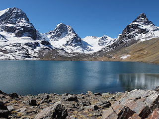
The La Paz Department of Bolivia comprises 133,985 square kilometres (51,732 sq mi) with a 2012 census population of 2,706,359 inhabitants. It is situated at the western border of Bolivia, sharing Lake Titicaca with adjacent Peru. It contains the Cordillera Real, which reaches altitudes of 6.6 kilometers (4.1 mi). Northeast of the Cordillera Real are the Yungas, the steep eastern slopes of the Andes Mountains that make the transition to the Amazon River basin to the northeast. The capital of the department is the city of La Paz and is the administrative city and seat of government/national capital of Bolivia.

The Plurinational Legislative Assembly is the national legislature of Bolivia, placed in La Paz, the country's seat of government.

Estadio Hernando Siles is a sports stadium in La Paz, Bolivia. It is the country's largest sports complex with a capacity of 41,143 seats. It is named after Hernando Siles Reyes, the 31st President of Bolivia (1926–1930). The stadium is located in the Miraflores borough of La Paz, at an altitude of 3,637 metres above sea level, making it one of the highest professional stadiums in the world. The Stadium was opened in 1931 with a match between The Strongest and its classic rival, Universitario, with The Strongest winning 4–1. It is the home ground of three major Bolivian league football clubs, Club Bolivar, The Strongest and La Paz F.C. as well as several smaller top sides: Universitario de La Paz, Chaco Petrolero and Mariscal Braun. The stadium also hosts lower league clubs: Fraternidad Tigres and Academia de Balompié Boliviano.

Pedro Domingo Murillo is a province in the Bolivian La Paz Department. It was created on January 8, 1838, with the name Cercado and on October 17, 1912, during the presidency of Eliodoro Villazón, its name was changed in honor of Pedro Domingo Murillo, protagonist of the revolution of June 16, 1809.

The Choqueyapu River, sometimes called the La Paz River, is a river in the La Paz Department of Bolivia. It belongs to the drainage basin of the Amazon. The river originates in a spring called Achachi Qala in the Cordillera Real near the mountain Chacaltaya at a height of 5,395 m. It crosses the city La Paz from north to south. South of Illimani and north of the Kimsa Cruz mountain range it turns to the east; at this point it is better known as the La Paz River. The confluence with Cotacajes River is the beginning of the Beni River, also known as Alto Beni in this region.

Calamarca or Qala Marka is the fourth municipal section of Aroma Province in the La Paz Department of Bolivia. It is located on the Altiplano and its seat is the town of Calamarca.

Collana Municipality is the seventh municipal section of the Aroma Province in the La Paz Department, Bolivia. Its seat is Collana.
Colquencha Municipality is the sixth municipal section of the Aroma Province in the La Paz Department, Bolivia. Its seat is Colquencha.
Laja Municipality is the second municipal section of the Los Andes Province in the La Paz Department, Bolivia. Its seat is Laja.
Puerto Pérez or Ch'ililaya (Aymara) is the fourth municipal section of the Los Andes Province in the La Paz Department, Bolivia. Its seat is Puerto Pérez.
Tito Yupanqui Municipality is the third municipal section of the Manco Kapac Province in the La Paz Department, Bolivia. Its seat is Tito Yupanqui.
Colquencha is a town in Aroma Province in the La Paz Department, Bolivia. It is the seat of the Colquencha Municipality.
Jesús de Machaca is a location in the La Paz Department, Bolivia. It is the seat of the Jesús de Machaca Municipality, the sixth municipal section of the Ingavi Province, and of the Jesús de Machaca Canton. In 2001 it had a population of 396.
Tiwanaku is a village in the La Paz Department, Bolivia with a population of 860 persons. Towards the south of the village there's the archaeological site of Tiwanaku.
Tito Yupanqui is a town in the La Paz Department, Bolivia. It was named after an indigenous artist, Francisco Tito Yupanqui, a 16th-century wood sculptor who sculptured a famous statue of the Blessed Virgin Mary, known as Our Lady of Candles.
San Andrés de Machaca is a town in the La Paz Department, Bolivia.
San Pedro de Tiquina is a town in the La Paz Department, Bolivia.
Huarina is a location in the La Paz Department in Bolivia. It is the seat of the Huarina Municipality, one of the four municipalities of the Omasuyos Province. President of Peru Andrés de Santa Cruz was born here.
American Cooperative School of La Paz or ACS Calvert (ACS), is an American international school in La Paz, Bolivia, serving kindergarten through grade 12.

The Cathedral Basilica of Our Lady of Peace, also called La Paz Cathedral, is a cathedral and minor basilica is located in Murillo Square in the city of La Paz in Bolivia. It was built in 1835 with a neoclassical architecture with Baroque elements. It has an interior consisting of five naves with different layers.
