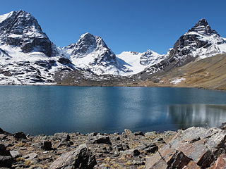
The La Paz Department of Bolivia comprises 133,985 square kilometres (51,732 sq mi) with a 2012 census population of 2,706,359 inhabitants. It is situated at the western border of Bolivia, sharing Lake Titicaca with adjacent Peru. It contains the Cordillera Real, which reaches altitudes of 6.6 kilometers (4.1 mi). Northeast of the Cordillera Real are the Yungas, the steep eastern slopes of the Andes Mountains that make the transition to the Amazon River basin to the northeast. The capital of the department is the city of La Paz and is the administrative city and seat of government/national capital of Bolivia.

Ingavi is a province in the La Paz Department in Bolivia. This is where the Battle of Ingavi occurred on November 18, 1841 and where the World Heritage Site of Tiwanaku is situated.

Los Andes is one of the twenty provinces in the central parts of the Bolivian La Paz Department. The province was legally founded on November 24, 1917, during the presidency of José Gutiérrez Guerra. The Spanish name of the province means "The Andes", referring to its position within the Cordillera Real which is part of the Bolivian Andes mountain range. The capital of the province is Pucarani, which has a population of 918 as of the 2001 census. Pucarani is situated in the Altiplano west of the Cordillera Real offering a view of some of its highest mountains such as Ch'iyar Juqhu, Chachakumani, Kunturiri, Wayna Potosí and Chacaltaya.

Omasuyos or Uma Suyu is a province in the La Paz Department in Bolivia. Its capital is Achacachi.

Pedro Domingo Murillo is a province in the Bolivian La Paz Department. It was created on January 8, 1838, with the name Cercado and on October 17, 1912, during the presidency of Eliodoro Villazón, its name was changed in honor of Pedro Domingo Murillo, protagonist of the revolution of June 16, 1809.

Desaguadero or Chaka Marka is a town on the Bolivian-Peruvian border. On the Bolivian side it is situated in the La Paz Department, Ingavi Province, Desaguadero Municipality, Desaguadero Canton. On the Peruvian side it lies in the Puno Region, Chucuito Province, Desaguadero District. Both parts of the town are united by a binational bridge.
Desaguadero Municipality is the fourth municipal section of Ingavi Province in La Paz Department, Bolivia. Its capital is Desaguadero.
Batallas Municipality is the third municipal section of the Los Andes Province in the La Paz Department, Bolivia. Its capital is Batallas.

Palca or Pallqa (Aymara) is the first municipal section of the Pedro Domingo Murillo Province in the La Paz Department, Bolivia. Its seat is Palca.
Calacoto or Qala Qutu is the third municipal section of the Pacajes Province in the La Paz Department, Bolivia. Its seat is Calacoto.

The Choqueyapu River, sometimes called the La Paz River, is a river in the La Paz Department of Bolivia. It belongs to the drainage basin of the Amazon. The river originates in a spring called Achachi Qala in the Cordillera Real near the mountain Chacaltaya at a height of 5,395 m. It crosses the city La Paz from north to south. South of Illimani and north of the Kimsa Cruz mountain range it turns to the east; at this point it is better known as the La Paz River. The confluence with Cotacajes River is the beginning of the Beni River, also known as Alto Beni in this region.
Cairoma Municipality is the fifth municipal section of the Loayza Province in the La Paz Department, Bolivia. Its seat is Cairoma.
Calamarca or Qala Marka is a town in the La Paz Department in Bolivia. It is the seat of Calamarca Municipality, the fourth municipal section of Aroma Province. It lies on the Altiplano on the east side of the main road between La Paz and Patacamaya, about 60 km south of La Paz.
Machacamarca is a small town in the La Paz Department in Bolivia. It is the seat of the Nueva Esperanza de Machacamarca Canton, one of the five cantons of the Colquencha Municipality which is the sixth municipal section of the Aroma Province. The town is situated at the railway that leads from La Paz to Oruro. At the time of census 2001 Machacamarca had a population of 1,400.
Villa Rosario de Wilacala is a village in the La Paz Department in Bolivia. It is the seat of the Villa Rosario de Wila Khala Canton, one of the five cantons of the Mocomoco Municipality which is the second municipal section of the Eliodoro Camacho Province. The village is situated 4,264 m high at the north-western edge of the Muñecas Mountain Range (Cordillera Muñecas) near the border to Peru. At the time of census 2001 it had a population of 303.
Qala T'uxu or Qala Tuqu is a mountain in the Cordillera Real in the Andes of Bolivia, about 5,076 metres (16,654 ft) high. It is located in the La Paz Department, Los Andes Province, Batallas Municipality, Chachacomani Canton. It is situated south-west of the mountains Wila Lluxi and Warawarani and north-west of the mountain Phaq'u Kiwuta.
Qala Phusa or Q'ululu is a 5,465-metre-high (17,930 ft) mountain in the Apolobamba mountain range in Bolivia. It situated in the La Paz Department, Franz Tamayo Province, Pelechuco Municipality. Qala Phusa lies southwest of Waracha and southeast of Jach'a Waracha.
Qala Phusa is a 4,884-metre-high (16,024 ft) mountain in the Andes of Bolivia. It is situated in the La Paz Department, Larecaja Province, Sorata Municipality. Qala Phusa lies north of the Janq'u Uma-Illampu massif of the Cordillera Real, northwest of the mountain Wila Quta and southeast of Llawi Imaña.
The Llallawa Jawira which upstream successively is named Patu Uma, Ch'alla Jawira, Jach'a Qura, Lupipi and Chuqi Phuju is a river in the La Paz Department in Bolivia. It is a left tributary of the Desaguadero River.

Samuel Plata Plata is a Bolivian auto mechanic and politician who served as a uninominal member of the Chamber of Deputies from La Paz, representing circumscription 22 from 2010 to 2015. Born in a peasant community in the Altiplano plateau, Plata scaled the ranks of traditional leadership, serving as president of the Chuncarcota school board, mallku of his Aymara township, and finally, jach'a mallku cantonal of the three ayllus in the Urinsaya Marka, the sector's highest indigenous authority. Plata's prominent local presence led regional peasant sectors to nominate him as their representative in the Legislative Assembly, with the Movement for Socialism sponsoring his successful candidacy for a seat in the Chamber of Deputies.


