Franz Tamayo Province | |
---|---|
Province | |
![]() Chalalan Lake | |
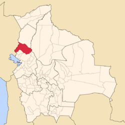
![]() Location of Franz Tamayo Province within Bolivia | |
![]() Provinces of the La Paz Department | |
Coordinates: 16°0′0″S67°5′0″W / 16.00000°S 67.08333°W | |
Country | ![]() |
Department | La Paz Department |
Municipalities | 2 |
Cantons | 9 |
Capital | Apolo |
Area | |
• Total | 15,900 km2 (6,100 sq mi) |
Population (2024 census) | |
• Total | 28,040 |
• Density | 1.8/km2 (4.6/sq mi) |
• Ethnicities | Quechua Aymara |
Time zone | UTC-4 (BOT) |
Area code | BO.LP.FT |
Website | Official website |
Franz Tamayo is a province in the Bolivian department of La Paz. It lies in the western part of the nation, and includes the Ulla Ulla National Reserve - which today is part of the Apolobamba Integrated Management Natural Area - in the high Andean plain on the western border with Peru. Its capital is Apolo.
The province was founded with the name Caupollcán on January 23, 1826. On December 20, 1967 the name was changed in honor of the Bolivian intellectual, writer and politician Franz Tamayo (1878–1956).
The Apolobamba mountain range traverses the province. The highest mountain of the province is Chawpi Urqu (Wisk'achani) at 6,044 m (19,829 ft). Other mountains are listed below: [1] [2]
Franz Tamayo Province is divided into two municipalities which are further subdivided into nine cantons.
Section | Municipality | Seat |
---|---|---|
1st | Apolo Municipality | Apolo |
2nd | Pelechuco Municipality | Pelechuco |
Some of the tourist attractions of the municipalities are: [3]
Other remarkable places are Pilón Lajas Biosphere Reserve and Communal Lands, Chalalan Lake and Chalalan ecolodge.
Bautista Saavedra is one of the twenty provinces of the Bolivian La Paz Department situated in the northwestern parts of the department. It was created on November 17, 1948 in honor of Bautista Saavedra Mallea (1870-1939) who was Bolivia's president from 1920 to 1925. The capital of the province is Charazani.
Larecaja is a province in the Bolivian La Paz Department. It was founded by Antonio José de Sucre on October 18, 1826. Its capital is Sorata.
Pedro Domingo Murillo is a province in the Bolivian La Paz Department. It was created on January 8, 1838, with the name Cercado and on October 17, 1912, during the presidency of Eliodoro Villazón, its name was changed in honor of Pedro Domingo Murillo, protagonist of the revolution of June 16, 1809.
Madidi is a national park in the upper Amazon river basin in Bolivia. It was established in 1995 with a total land area of 18,958 km2. Together with the nearby protected areas Manuripi-Heath and Apolobamba and the Manu Biosphere Reserve (Peru), Madidi is part of one of the largest protected areas in the world.
Chalalán is an ecological lodge of the Indigenous People of San José de Uchupiamonas dedicated to ethnic ecotourism. It is located in the Madidi National Park in Bolivia. The cabins are located in the vicinity of Chalalán Lake, on the south bank of the Tuichi River, about 100 km south west of Rurrenabaque.
Apolobamba(Cordillera Apolobamba) is a mountain range in the South American Andes.
Cololo Lake is a lake in the Apolobamba mountain range in the La Paz Department in Bolivia. It is situated in the Antaquilla de Copacabana Canton of the Pelechuco Municipality in the Franz Tamayo Province at an elevation of 4,538 m at a distance of about 20 km north west from the Cololo mountain. Its surface area is 5.2 km2.
Apolo Municipality is the first municipal section of the Franz Tamayo Province in the La Paz Department, Bolivia. Its seat is Apolo.
Pelechuco Municipality is the second municipal section of the Franz Tamayo Province in the La Paz Department, Bolivia. IN 2001 it had apopulation of 5,115. Its seat is Pelechuco.
Chaupi Orco or Viscachani is a mountain in the Andes on the border of Bolivia and Peru. It has a height of 6,044 metres (19,829 ft). On the Bolivian side it is located in the La Paz Department, Franz Tamayo Province, Pelechuco Municipality, and on the Peruvian side it lies in the Puno Region, Putina Province, Sina District. It lies north of Salluyu. Chaupi Orco is the highest peak of the Apolobamba mountain range.
Ulla Qhaya, Jila Khayo, Huelancalloc, Huellancalloc or Pupuya is a 5,617-metre-high (18,428 ft) mountain in the Apolobamba mountain range in Bolivia. It is situated in the La Paz Department at the border of the Bautista Saavedra Province, Curva Municipality, and the Franz Tamayo Province, Pelechuco Municipality. Ulla Qhaya lies east of the lake Ch'uxña Quta and north-west of the mountain Iskillani.
K'ayrani Quta is a lake west of the Apolobamba mountain range in the Andes of Bolivia. It is situated in the La Paz Department, Franz Tamayo Province, Pelechuco Municipality.
K'iski Quta is a lake in the Apolobamba mountain range in the Andes of Bolivia. It is situated in the La Paz Department, Franz Tamayo Province, Pelechuco Municipality. K'iski Quta lies northwest of the mountain Jach'a Waracha.
Chawpi Urqu is a 4,617-metre-high (15,148 ft) mountain in the Apolobamba mountain range in Bolivia. It is located in the La Paz Department, Franz Tamayo Province, Pelechuco Municipality, near the Peruvian border. Chawpi Urqu lies east of the mountains Surapata and Kulli Pata and north of Q'umir Pata.
Q'umir Pata is a mountain in the north of the Apolobamba mountain range in Bolivia, about 4,720 metres (15,486 ft) high. It is located in the La Paz Department, Franz Tamayo Province, Pelechuco Municipality, near the Peruvian border. Q'umir Pata lies southeast of the mountains Surapata and Kulli Pata and south of Chawpi Urqu.
Kulli Pata or Kullipata is a mountain in the north of the Apolobamba mountain range in Bolivia, about 4,800 metres (15,748 ft) high. It is located in the La Paz Department, Franz Tamayo Province, Pelechuco Municipality, near the Peruvian border. Kulli Pata lies west of Chawpi Urqu and northeast of Surapata.
Punta Yavre or Punta Yayre is a mountain in the northeast of the Apolobamba mountain range on the border of Bolivia and Peru. It is about 4,600 metres (15,092 ft) high. On the Bolivian side it is located in the La Paz Department, Franz Tamayo Province, Pelechuco Municipality, and on the Peruvian side it lies in the Puno Region, Putina Province, Sina District. Punta Yavre is situated northwest and northeast of the mountains Chawpi Urqu and Kulli Pata.
Wank'uchiri is a 5,382-metre-high (17,657 ft) mountain in the Apolobamba mountain range in the Andes of Bolivia. It is located in the La Paz Department, Franz Tamayo Province, Pelechuco Municipality, near the Peruvian border. Wank'uchiri is situated southwest of the mountain Chuquyu, northwest of K'iski Quta and southeast of Palumani and Such'i Lake. A little lake named Saywa Quta (Saihuacota) lies at its feet, south of it.
Chinkani is a mountain east of the Apolobamba mountain range in the Andes of Bolivia, about 4,600 metres (15,092 ft) high. It is located in the La Paz Department, Franz Tamayo Province, Pelechuco Municipality. Chinkani lies northeast of the mountain Allqamarini and east of Q'umir Pata at a small lake and river named Quchapata (Khochapata).
Sorapata is a mountain in the north of the Apolobamba mountain range on the border of Bolivia and Peru. It is about 6,000 metres (19,685 ft) high. On the Bolivian side it is located in the La Paz Department, Franz Tamayo Province, Pelechuco Municipality, and on the Peruvian side it lies in the Puno Region, Putina Province, Sina District. Sorapata is situated between Locopauchenta and Cunuyo in the north and Chaupi Orco in the south. The lake Japucocha lies southwest of it.