Bautista Saavedra is one of the twenty provinces of the Bolivian La Paz Department situated in the northwestern parts of the department. It was created on November 17, 1948 in honor of Bautista Saavedra Mallea (1870-1939) who was Bolivia's president from 1920 to 1925. The capital of the province is Charazani.

The Ocongate District is one of the twelve districts in the Quispicanchi Province in Peru. Created on January 2, 1857, its capital is the town of Ocongate.

Curva Municipality is the second municipal section of the Bautista Saavedra Province in the La Paz Department, Bolivia. Its seat is Curva.
Jolljepunco, Colquepunco or Sasahui (sasawi) local name for Leucheria daucifolia, -ni an Aymara suffix to indicate ownership, "the one with the sasawi plant", hispanicized Sasahuini) is a mountain in the Andes of Peru and the name of a lake near the peak. The mountain is about 5,522 metres (18,117 ft) high. It is situated in the northern extensions of the Vilcanota mountain range in the Cusco Region, Quispicanchi Province, in the districts Ccarhuayo and Ocongate and in the Paucartambo Province, Kosñipata District. Jolljepunco lies northwest of the lake Singrenacocha, southeast of Minasnioc. The lake named Jolljepunco is situated south of the mountain at 13°32′04″S71°12′29″W.

Huayruro Punco is a mountain in the Vilcanota mountain range in the Andes of Peru, about 5,550 metres (18,209 ft) high. It is situated in the Cusco Region, Canchis Province, Pitumarca District. Huayruro Punco lies southeast of Callangate, southwest of Chumpe and north of Cóndor Tuco and Comercocha, between the Chillcamayu which originates near Huayruro Punco and the lake named Sibinacocha.
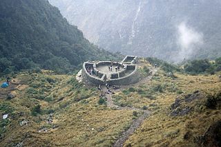
Runkuraqay or Runku Raqay is an archaeological site on a mountain of the same name in Peru located in the Cusco Region, Urubamba Province, Machupicchu District. It is situated southeast of the archaeological site Machu Picchu and south of the Vilcanota river. The ruins lie on the southern slope of the mountain Runkuraqay near the Runkuraqay pass, northeast of the archaeological site Sayacmarca and southeast of the site Qunchamarka.

Saqra is a traditional dance in the highlands of the Cusco Region in Peru. The dancers dress as animal figures. This traditional dance has its origins in the late 19th century in the province of Paucartambo, Cusco and was inspired by the sacred paintings of the so called “Mamacha Carmen” also known as the "Virgen del Carmen". Saqra means roguery, restlessness, agility or mischief in English.

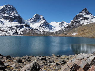
Wila Kunka is a mountain in the Apolobamba mountain range in Bolivia, about 4,520 metres (14,829 ft) high. It is situated in the La Paz Department, Bautista Saavedra Province, Curva Municipality. Wila Kunka lies south of the mountains Ulla Qhaya and Iskillani.
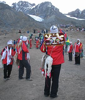
Anta Punco is mountain in the northern extensions of the Vilcanota mountain range in the Andes of Peru, about 5,000 metres (16,404 ft) high. It is located in the Cusco Region, Quispicanchi Province, Ocongate District. Anta Punco lies west of Jarjapata and southeast of Jolljepunco where the annual Quyllur Rit'i festival takes place.

Ticlla is a 5,303-metre-high (17,398 ft) mountain in the Chila mountain range in the Andes of Peru. It is located in the Arequipa Region, Castilla Province, Chachas District. Ticlla lies southwest of Chila and Chila Pillune at a valley named Puncuhuaico. Its intermittent stream flows to Chachas Lake.
Yuaytacondorsenja is a 5,345-metre-high (17,536 ft) mountain in the Chila mountain range in the Andes of Peru. It is located in the Arequipa Region, Castilla Province, Chachas District. Yuaytacondorsenja lies northwest of Chila and Chila Pillune. It is situated at the end of a valley named Puncuhuaico. Its stream flows to Chachas Lake.
P'unquchayuq is a mountain in the Cusco Region in Peru, about 4,400 metres (14,436 ft) high. It is situated in the Calca Province, San Salvador District, and in the Paucartambo Province, Caicay District. P'unquchayuq lies south of Hatun Punta and southeast of Qhiwar.
Saqra Mach'ay is a mountain in the Andes of Peru, about 4,600 m (15,100 ft) high. It is located in the Pasco Region, Daniel Alcides Carrión Province, Yanahuanca District. Saqra Mach'ay lies southwest of Puka Mach'ay.
Saqra Mach'ay is a mountain in the Andes of Peru, about 4,750 m (15,580 ft) high. It is located in the Huánuco Region, Pachitea Province, Panao District, and in the Pasco Region, Pasco Province, Ticlacayan District. Saqra Mach'ay lies northwest of the Waqurunchu mountain range, southeast of Wamanripayuq.
Puncuyoc is a mountain north of the Urubamba mountain range in the Andes of Peru, about 4,400 m (14,400 ft) high. It is located in the Cusco Region, La Convención Province, Ocobamba District. Puncuyoc lies northeast of Llaulliyoc.
Saqra Waqra is a mountain in the Andes of Peru which reaches a height of approximately 4,000 m (13,000 ft). It is located in the Huánuco Region, Dos de Mayo Province, Marías District. Saqra Waqra lies southwest of a lake named Ñat'inqucha.
Sagrahuagra is a mountain in the Andes of Peru which reaches a height of approximately 4,200 m (13,800 ft). It is located in the Huánuco Region, Huánuco Province, Churubamba District.
Supay Q'asa is a mountain in the Bolivian Andes which reaches a height of approximately 2,920 m (9,580 ft). It is located in the Chuquisaca Department, Tomina Province, Sopachuy Municipality. It lies at the Supay Q'asa River.
Anta P'unqu is a mountain in the Cordillera Central in the Andes of Peru which reaches a height of approximately 4,800 metres (15,748 ft). It is located in the Lima Region, Yauyos Province, Huantán District. Anta P'unqu lies northwest of Paquchi.
Yana P'unqu is mountain Cordillera Central in the Andes of Peru which reaches a height of approximately 4,800 metres (15,748 ft). It is located in the Lima Region, Yauyos Province, Laraos District. Yana P'unqu lies north of a lake named Pumaqucha.