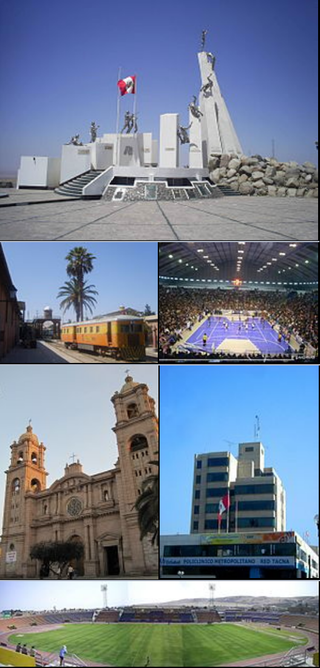
Tacna is a city in southern Peru and the regional capital of the Tacna Region. A very commercially active city, it is located only 35 km (22 mi) north of the border with Arica y Parinacota Region from Chile, inland from the Pacific Ocean and in the valley of the Caplina River. It is Peru's tenth most populous city.

The Atacama Desert border dispute was a dispute between Chile and Bolivia from 1825 to 1879 for the territories of the Atacama Coast due to the different views of both countries of the territory inherited from the Spanish Empire. During the dispute, both countries signed Treaties in 1866 and 1874. The dispute occurred prior to the War of the Pacific, which settled the dispute in favor of Chile. Due to the surrender of land by Bolivia, the Puna de Atacama dispute was generated between Chile and Argentina and was settled in 1899.
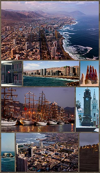
Antofagasta is a port city in northern Chile, about 1,100 kilometres (700 mi) north of Santiago. It is the capital of Antofagasta Province and Antofagasta Region. According to the 2015 census, the city has a population of 402,669.

The Diego Ramírez Islands are a small group of subantarctic islands located in the southernmost extreme of Chile.
Grímsey is a small Icelandic island, 40 kilometres off the north coast of the main island of Iceland, straddling the Arctic Circle. In January 2018 Grímsey had 61 inhabitants.
Ōmu is a town located in Okhotsk Subprefecture, Hokkaido, Japan.
Ndilǫ is a First Nations community in the North Slave Region of the Northwest Territories, Canada. The small Dene community is located on the edge of Yellowknife on the tip of Latham Island. It had a population of approximately 321 people in 2016. Ndilǫ and Dettah are the communities of the Yellowknives. Ndilǫ is represented by the Yellowknives Dene First Nation (Ndilǫ) and are part of the Akaitcho Territory Government.

Mjóifjörður is a village of 7 people in East Iceland, sitting on a fjord of the same name. It is part of the municipality of Fjarðabyggð.

Le Luc, also known as Le Luc-en-Provence, is a commune in the Var department in the Provence-Alpes-Côte d'Azur region in Southeastern France. In 2019, it had a population of 11,094. Le Luc is the seat of its own canton, the larger canton of Le Luc. Inhabitants of Le Luc are called Lucois (masculine) and Lucoises (feminine).

Inukjuak is a northern village located on Hudson Bay at the mouth of the Innuksuak River in Nunavik, in the Nord-du-Québec region of northern Quebec, Canada. Its population is 1,821 as of the 2021 Canadian Census. An older spelling is Inoucdjouac; its former name was Port Harrison.

Ardtalnaig is a hamlet on the south shore of Loch Tay in Perth and Kinross in Scotland. It is approximately 6 miles (10 km) from Kenmore in whose parish it lies.
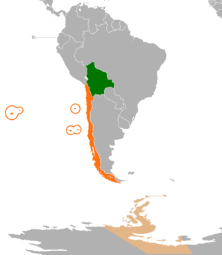
International relations between the Republic of Chile and the Plurinational State of Bolivia have been strained ever since independence in the early 19th century because of the Atacama border dispute. Relations soured even more after Bolivia lost its coast to Chile during the War of the Pacific and became a landlocked country. Chile and Bolivia have maintained only consular relations since 1978, when territorial negotiations failed and Bolivia decided to sever diplomatic relations with Chile. However, in spite of straining relationship, Chile and Bolivia still have economic treaties supporting tourism and cooperation; therefore, trading between two nations is not affected by the territorial dispute.
Les Moutiers-en-Retz is a commune in the Loire-Atlantique department in western France.

The Arica–La Paz railway or Ferrocarril de Arica–La Paz (FCALP) was built by the Chilean government under the Treaty of Peace and Friendship of 1904 between Chile and Bolivia. The railway line was inaugurated on 13 May 1913 and is the shortest line from the Pacific Coast to Bolivia. It is 440 km (273 mi) long, of which 233 km (145 mi) is in Bolivian territory. The Railway is meter gauged. However, until 1968, it was rack worked over a 43 km section, on the Chilean side, between Central and Puquios. The line reaches a height of 4257 meters above sea level at General Lagos. The Chile - Bolivia border is crossed between the stations of Visviri and Charaña. When the railway is in operation, it is used for the export of Bolivian minerals and some agricultural production as well as the import of merchandise into Bolivia.
Charaña Municipality is the fifth municipal section of the Pacajes Province in the La Paz Department, Bolivia. Its seat is Charaña.

Laram Q'awa is a 5,182-metre-high (17,001 ft) mountain in the Andes. According to the Bolivian IGM map 1:50,000 'Nevados Payachata Hoja 5739-I' it is situated on Bolivian terrain in the La Paz Department, Pacajes Province, at the border with Chile. It lies north-west of the mountains Kunturiri, Phaq'u Q'awa and another mountain on the border named Laram Q'awa (Laram Khaua). One of three different rivers of this area called Kunturiri (Condoriri) originates north-east of the mountain near Phaq'u Q'awa. It flows in a bow along the northern slopes of Laram Q'awa towards Chile.
Charaña Airport Spanish: Aeropuerto Charaña, is an extremely high elevation airstrip serving Charaña, a town in the altiplano of the La Paz Department of Bolivia. The airport is east of the town and 3 kilometres (1.9 mi) east of the border with Chile.
Phaq'u Q'awa is a 5,252-metre-high (17,231 ft) mountain in the Andes. According to the Bolivian IGM map 1:50,000 'Nevados Payachata Hoja 5739-I' it is situated on Bolivian terrain in the La Paz Department, Pacajes Province, Charaña Municipality, at the border with Chile. Phaq'u Q'awa lies north-west of the mountain Kunturiri and south-east of the mountain Laram Q'awa. The nearest peak to the east is Jaruma. One of three different rivers of this area called Kunturiri (Condoriri) originates north of the mountain. It flows in a bow along the northern slopes of Laram Q'awa towards Chile.

The Charaña Accord, also known as the Hug of Charaña or the Act of Charaña, is the name given to an unrealized treaty that was discussed between the dictators of Bolivia and Chile, Hugo Banzer and Augusto Pinochet respectively. These discussions took place mostly on the Bolivian train station of Charaña on February 8, 1975, and included the brief reestablishment of diplomatic relations between the two nations which had been severed on 1962 because of the Atacama border dispute which was to be solved via a Chilean proposal for the exchange of territories between Bolivia and Chile, with the former receiving a corridor to the Pacific Ocean which would provide it with access to the sea and Chile receiving an equivalent amount of territory from Bolivia along its border with Chile.

The Chilean–Peruvian territorial dispute is a territorial dispute between Chile and Peru that started in the aftermath of the War of the Pacific and ended significantly in 1929 with the signing of the Treaty of Lima and in 2014 with a ruling by the International Court of Justice. The dispute applies since 2014 to a 37,610 km2 territory in the Chile–Peru border, as a result of the maritime dispute between both states.

