Aroma Province

Last updated
Aroma
Province
P8040003 Illimani.JPG
Illimani, as seen from Collana
Bolivia La Paz Aroma.png
Location of Aroma Province within Bolivia
Bolivia Departamento La Paz.png
Provinces of the La Paz Department
Coordinates: 17°20′0″S67°50′0″W / 17.33333°S 67.83333°W / -17.33333; -67.83333
Country Flag of Bolivia.svg Bolivia
Department La Paz Department
Capital Sica Sica (Sika Sika)
Area
  Total4,510 km2 (1,740 sq mi)
Population
 (2024 census)
  Total112,015
  Density25/km2 (64/sq mi)
  Ethnicities
Aymara
Time zone UTC-4 (BOT)

Aroma is one of the twenty provinces of the Bolivian La Paz Department. It is situated in the southern parts of the department. Its seat is Sica Sica (Sika Sika).

Contents

Location

Aroma province is located between 16° 43' and 17° 35' South and between 67° 22' and 68° 23' West. It extends over 120 km from north west to south east, and up to 55 km from north east to south west.

The province is situated on the Bolivian Altiplano south east of Lake Titicaca and borders Ingavi Province in the north west, Pacajes Province in the west, Gualberto Villarroel Province in the south, Oruro Department in the south east, Loayza Province in the east, and Pedro Domingo Murillo Province in the north.

Geography

Some of the highest mountains of the province are listed below: [1]

Population

The population of Aroma Province has increased by 80% over the recent two decades:

45.1% of the population are younger than 15 years old. (1992)

79.9% of the population speak Spanish, 93.9% speak Aymara, and 6.7% Quechua. (2001)

The literacy rate of the population of the province is 78.4%. (1992)

82.1% of the population have no access to electricity, 88.0% have no sanitary facilities. (1992)

69.2% of the population are Catholics, 25.5% are Protestants. (1992)

Division

The province comprises seven municipios which are further subdivided into cantons.

SectionMunicipalityInhabitants (2001) [3] SeatInhabitants (2001) [3]
1st Sica Sica Municipality 26,818 Sica Sica 3,831
2nd Umala Municipality 9,583 Umala 152
3rd Ayo Ayo Municipality 6,981 Ayo Ayo 647
4th Calamarca Municipality 12,112 Calamarca 943
5th Patacamaya Municipality 20,039 Patacamaya 8,414
6th Colquencha Municipality 8,020 Colquencha 2,352
7th Collana Municipality 2,927 Collana 1,936

Villages

See also

Related Research Articles

<span class="mw-page-title-main">Puno Province</span> Province in Puno, Peru

Puno is a province in the Puno Region, in southeastern Peru. It borders the provinces of Huancane, San Román, El Collao and the Moquegua Region's province of General Sánchez Cerro. Its capital is the city of Puno, which is located at the edge of Lake Titicaca, the world's highest navigable lake. It is the economic powerhouse of the region.

<span class="mw-page-title-main">Tapacarí Province</span> Province in Bolivia

Tapacarí is a province in the Cochabamba Department, Bolivia. Its capital is Tapacarí. The province is located at a turnoff from the major highway that links Cochabamba and Oruro. It has traditionally been amongst the poorest in the department. Tapacarí Province and neighboring Arque Province are the two poorest of the 16 provinces that make up the department of Cochabamba.

<span class="mw-page-title-main">Ingavi Province</span> Province in La Paz Department, Bolivia

Ingavi is a province in the La Paz Department in Bolivia. This is where the Battle of Ingavi occurred on November 18, 1841, and where the World Heritage Site of Tiwanaku is situated.

<span class="mw-page-title-main">Inquisivi Province</span> Province in La Paz, Bolivia

Inquisivi is a province in the La Paz Department in Bolivia. During the presidency of José Ballivián it was created on November 2, 1844. The capital of the province is Inquisivi.

<span class="mw-page-title-main">Larecaja Province</span> Province in La Paz Department, Bolivia

Larecaja is a province in the Bolivian La Paz Department. It was founded by Antonio José de Sucre on October 18, 1826. Its capital is Sorata.

<span class="mw-page-title-main">Loayza Province</span> Province in La Paz Department, Bolivia

Loayza or José Ramón Loayza is a province in the La Paz Department, Bolivia. Its seat is Luribay.

<span class="mw-page-title-main">Pacajes Province</span> Province in La Paz Department, Bolivia

Pacajes is a province in the Bolivian department of La Paz. Its capital is Coro Coro.

<span class="mw-page-title-main">Tomás Frías Province</span> Province in Potosí Department, Bolivia

Tomás Frías is a province in the northern parts of the Bolivian Potosí Department. Its capital is Potosí which is also the capital of the department. The province is named after the former president Tomás Frías Ametller.

<span class="mw-page-title-main">Antonio Quijarro Province</span> Province in Potosí Department, Bolivia

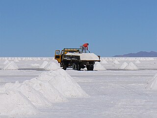
Antonio Quijarro is a province in the central parts of the Bolivian Potosí Department situated at the Salar de Uyuni. Its seat is Uyuni.

<span class="mw-page-title-main">San Pedro de Totora Province</span> Province in Oruro, Bolivia

San Pedro de Totora is a province in the northern parts of the Bolivian department of Oruro.

<span class="mw-page-title-main">Turco Municipality</span> Municipality in Oruro Department, Bolivia

Turco Municipality is the second municipal section of the Sajama Province in the Oruro Department in Bolivia, and was founded on February 15, 1957. Its seat is Turco, situated 154 km west of Oruro at an altitude of 3,860 m. The municipality covers an area of 3,973 km², not taking into account the area of Laca Laca Canton.

<span class="mw-page-title-main">Chucuito Province</span> Province in Puno, Peru

Chucuito Province is a province of the Puno Region in Peru. The capital of the province is the city of Juli.

<span class="mw-page-title-main">Pichacani District</span> District in Puno, Peru

Pichacani or Pichaqani is one of fifteen districts of the Puno Province in the Puno Region in Peru.

Calacoto or Qala Qutu is the third municipal section of the Pacajes Province in the La Paz Department, Bolivia. Its seat is Calacoto.

Luribay Municipality is the first municipal section of the Loayza Province in the La Paz Department, Bolivia. Its seat is Luribay.

Colquiri Municipality is the fourth municipal section of the Inquisivi Province in the La Paz Department, Bolivia. Its seat is Colquiri.

Malla Municipality is the fourth municipal section of the Loayza Province in the La Paz Department, Bolivia. Its seat is Malla.

Patacamaya or Patakamaya (Aymara) is the fifth municipal section of the Aroma Province in the La Paz Department, Bolivia. Its seat is Patacamaya.

Sica Sica Municipality is the first municipal section of the Aroma Province in the La Paz Department, Bolivia. Its seat is Sica Sica.

<span class="mw-page-title-main">Chilla-Kimsa Chata mountain range</span> Mountain in Bolivia

The Chilla-Kimsa Chata mountain range is situated in Bolivia south east of Wiñaymarka Lake, the southern part of Lake Titicaca, in the La Paz Department, Ingavi Province. The range is named after one of highest mountains, the Kimsa Chata complex rising up to 4,735 metres (15,535 ft) about 15 km south of Tiwanaku.

References

  1. IGM map 1:50,000 Sicasica 6042-II
  2. "Bolivia: Administrative Division (Departments and Provinces) - Population Statistics, Charts and Map". www.citypopulation.de. Retrieved 2024-09-11.
  3. 1 2 National Institute of Statistics of Bolivia Archived 2009-10-27 at the Wayback Machine (in Spanish)

17°20′S67°50′W / 17.333°S 67.833°W / -17.333; -67.833