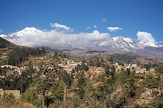
Sorata is a small town in the La Paz Department in the Bolivian Andes, northwest of the city of La Paz and east of Lake Titicaca. It is the seat of the Larecaja Province and the Sorata Municipality. At the time of census 2001 it had a population of 2,217. It is a somewhat popular weekend getaway and a relaxing base camp for a growing number of hikers. It includes several small hotels, including a converted Italian mansion.

Illampu is the fourth highest mountain in Bolivia. It is located in the northern section of the Cordillera Real, part of the Andes, east of Lake Titicaca. It lies just north of the slightly higher Janq'u Uma, near the town of Sorata. Laguna Glaciar, located in the Illampu-Janq'u Uma massif, is the 17th highest lake in the world.

Sorata Municipality is the first municipal section of the Larecaja Province in the La Paz Department, Bolivia. Its capital is Sorata. The Illampu - Janq'u Uma massif is located within the municipality, site of the 17th highest lake in the world, Laguna Glaciar.
Q'asiri is a mountain in the Cordillera Real in the Andes of Bolivia, about 5,828 m (19,121 ft) high. It is located in the La Paz Department, Larecaja Province, Sorata Municipality. It is situated south-east of the mountain Janq'u Uma, north-west of the mountains Qalsata and Ch'iyar Juqhu and north-east of San Francisco Lake.
Ch'iyar Qullu is a 4,875-metre-high (15,994 ft) mountain in the north of the Cordillera Real in the Andes of Bolivia. It is situated in the La Paz Department, Larecaja Province, Sorata Municipality. Ch'iyar Qullu lies west of the Janq'u Uma-Illampu massif and north-east of the mountain Achachi Qullu (Achachi Kkollu).

Jach'a Pukara is a mountain in the Andes of Bolivia, about 4,300 metres (14,108 ft) high. It is situated in the La Paz Department, Larecaja Province, Sorata Municipality. Jach'a Pukara lies between Lake Titicaca in the west and the Janq'u Uma-Illampu massif of the Cordillera Real in the east.
Janq'u Quta is a lake in the Cordillera Real in the Andes of Bolivia. It is located in the La Paz Department, Larecaja Province, in the south-west of the Guanay Municipality. Janq'u Quta lies near the mountain Ch'iyar Juqhu. Lake can be reached from village Chajolpaya, Municipio Sorata, Provincia Larecaja, La Paz, Bolivia.
Uma Jalanta is a mountain in the Cordillera Real in the Andes of Bolivia, about 5,723 metres (18,776 ft) high. It is located in the La Paz Department, Larecaja Province, Sorata Municipality. It lies south-east of the mountains Janq'u Uma and Janq'u Piti, near the mountain Misk'i T'ant'a.
Yapuchañani is a mountain in the Cordillera Real in the Andes of Bolivia, about 5,526 metres (18,130 ft) high. It is located in the La Paz Department, Larecaja Province, Sorata Municipality. It lies northeast of Misk'i T'ant'a and Uma Jalanta, east of Janq'u Uma and Janq'u Piti and southeast of Wiluyu Janq'u Uma.
Wiluyu Janq'u Uma or Wiluyu is a mountain in the Cordillera Real in the Andes of Bolivia, about 5,540 metres (18,176 ft) high. It is located in the La Paz Department, Larecaja Province, Sorata Municipality. It lies northwest of the mountain Yapuchañani, northeast of Misk'i T'ant'a and Uma Jalanta and east of Illampu.
Janq'u K'ark'a is a mountain in the Cordillera Real in the Andes of Bolivia, about 5,200 metres (17,060 ft) high. It is situated in the La Paz Department, Larecaja Province, Sorata Municipality, and in the Omasuyos Province, Achacachi Municipality. Janq'u K'ark'a lies south of the Janq'u Uma-Illampu massif, southeast of the mountain Quña Quñani and the lakes Warawarani (Huara Huarani) and Jisk'a Warawarani (Jiskha Huara Huarani).
Wila Quta is a mountain in the Andes of Bolivia, about 4,960 metres (16,273 ft) high. It is situated in the La Paz Department, Larecaja Province, Sorata Municipality, north of the massif of Janq'u Uma and Illampu of the Cordillera Real. The river Janq'u Uma Jawira originates south of the mountain. It flows to the north-east.
Warus Quta is a lake in the Cordillera Real in the Andes of Bolivia. It is situated in the La Paz Department, Larecaja Province, Sorata Municipality. Warus Quta lies south-east of the mountains Wiluyu Janq'u Uma and Yapuchañani and north-east of Uma Jalanta.
Ch'uch'u Jawira is a Bolivian river in the La Paz Department, Larecaja Province, Sorata Municipality. Its waters flow the Kaka River which belongs to the watershed of the Beni River.
P'iq'iñ Qullu is a mountain in the north of the Cordillera Real in the Andes of Bolivia, about 4,875-metre (15,994 ft) high. It is situated in the La Paz Department, Larecaja Province, Sorata Municipality. P'iq'iñ Qullu lies west of the Janq'u Uma-Illampu massif southeast of Sorata.
Jach'a Apachita is a mountain in the Andes of Bolivia, about 4,420 metres (14,501 ft) high. It is situated in the La Paz Department, Larecaja Province, Sorata Municipality. Jach'a Apachita lies northeast of the Janq'u Uma-Illampu massif of the Cordillera Real.
Jukumarini is a 4,552-metre-high (14,934 ft) mountain in the Andes of Bolivia. It is situated in the La Paz Department, Larecaja Province, Sorata Municipality. Jukumarini lies north of the main range of the Cordillera Real, southwest of the mountain Ch'uch'u and west of Ch'uch'u Apachita.
Ch'uxñani is a 4,680-metre-high (15,354 ft) mountain in the Andes of Bolivia. It is located in the La Paz Department, Larecaja Province, Sorata Municipality, in the northern extensions of the Cordillera Real southeast of the mountain Jach'a Waylla Punta. Ch'uxñani lies near the confluence of the rivers Ch'uch'u Jawira which comes from the northwest and Jach'a Uma Jawira which originates between the mountain Wila Quta and the Janq'u Uma-Illampu massif.
Qala Phusa is a 4,884-metre-high (16,024 ft) mountain in the Andes of Bolivia. It is situated in the La Paz Department, Larecaja Province, Sorata Municipality. Qala Phusa lies north of the Janq'u Uma-Illampu massif of the Cordillera Real, northwest of the mountain Wila Quta and southeast of Llawi Imaña.
Quña Quñani is a 5,006-metre-high (16,424 ft) mountain in the north of the Cordillera Real in the Andes of Bolivia. It is located in the La Paz Department, Larecaja Province, Sorata Municipality. Quña Quñani lies south of the Janq'u Uma-Illampu massif between the lakes Laram Quta in the northwest and Warawarani (Huara Huarani) and Jisk'a Warawarani (Jiskha Huara Huarani) in the east and southeast. It is situated north and northwest of the mountains Salluyu (Salluyo) and Janq'u K'ark'a.


