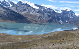
The Cordillera Blanca is a mountain range in Peru that is part of the larger Andes range and extends for 200 kilometres (124 mi) between 8°08' and 9°58'S and 77°00' and 77°52'W, in a northwesterly direction. It includes several peaks over 6,000 metres (19,690 ft) high and 722 individual glaciers. The highest mountain in Peru, Huascarán, at 6,768 metres (22,205 ft) high, is located there.
The Cordillera Negra, Yana Walla in qechua is part of the Cordillera Occidental, one of three mountain ranges in the Andes of west central Peru. It is almost entirely located within the Ancash Region.

Macari District is one of nine districts of the Melgar Province in Peru. The capital of the district is Macari.

Chaupi Orco or Viscachani is a mountain in the Andes on the border of Bolivia and Peru. It has a height of 6,044 metres (19,829 ft). On the Bolivian side it is located in the La Paz Department, Franz Tamayo Province, Pelechuco Municipality, and on the Peruvian side it lies in the Puno Region, Putina Province, Sina District. It lies north of Salluyu. Chaupi Orco is the highest peak of the Apolobamba mountain range.

The Cordillera Vilcanota is a mountain range located in Peru southeast of Cusco, on the boundary between the regions of Cusco and Puno. It extends between 13°39' and 14°29'S and 70°31' and 71°20'W for about 80 km. It includes 469 glaciers.
The Cordillera Quimsa Cruz is a mountain range in the La Paz Department in Bolivia situated south east of Lake Titicaca and north of Lake Uru Uru, measuring about 35–40 km in length and 12 km at its widest point. It is the continuation of the Cordillera Real of Bolivia extending in a north to south-eastern direction from Asiento pass south of Illimani to Tres Cruces pass.
Wila Lluxita is a 5,244-metre-high (17,205 ft) mountain in the Andes. It is located in the Cordillera Real of Bolivia in the La Paz Department, Larecaja Province, Guanay Municipality. It is situated at the end of the Janq'u Quta valley between Janq'u Laya and Janq'u Uyu in the west and Mullu Apachita in the southeast, all of them higher than 5,000 m.

The Huaytapallana mountain range lies in the Junín Region in the Andes of Peru. It extends between 11°47' and 11°56'S and 75°00' and 75°05'W for about 17 km. The surface area of the zone is 378'40 km2. The range is located in the provinces of Concepción and Huancayo.

The Urubambamountain range lies in the Cusco Region in Peru. It extends in a northwesterly direction between 13°08' and 13°17'S and 71°58' and 72°16'W for about 30 km.

The Chonta mountain range lies in the Huancavelica Region in the Andes of Peru. It extends between 12°37' and 13°07'S and 75°00' and 75°30'W for about 50 km. It is located in the Castrovirreyna Province and in the Huancavelica Province.
Raura is a mountain range located in the Andes of Peru, on the boundaries of the regions of Huánuco, Lima and Pasco. It extends between 10°21' and 10°31'S and 76°41' and 76°50'W for about 20 km. It lies a few kilometres southeast of Huayhuash mountain range.
Riti Urmasca or Ritiurcamasca is a mountain in the Andes of Peru, about 5,200 metres (17,060 ft) high. It is situated in the Puno Region, Putina Province, on the border of the districts Ananea and Sina. Riti Urmasca lies southeast of the mountain Ritipata and southwest of Chaupi Orco at the mountain pass Iscaycruz.
Llusca Ritti is a mountain in the Vilcanota mountain range in the Andes of Peru, about 5,200 metres (17,060 ft) high. It is located in the Puno Region, Carabaya Province, Corani District. Llusca Ritti lies southeast of the mountains Taruca Sayana and Quello Sallayoc, southwest of the mountain Riti Huasi and north of the mountain Yana Sallayoc.
Churu is a 5,200-metre-high (17,060 ft) mountain in the Cordillera Real in the Bolivian Andes. It is situated in the La Paz Department, Sud Yungas Province, Irupana Municipality, near the border with the Murillo Province, Palca Municipality. Churu lies south-west of the mountain Mururata, west of a small lake named Qillwa Quta, east of the mountain Wila Quta and south-east of the mountain Qutapata.
Rit'i Apachita is a 5,029-metre-high (16,499 ft) mountain in the Apolobamba mountain range in Bolivia. It is situated in the La Paz Department, Franz Tamayo Province, Pelechuco Municipality, north-west of Pelechuco. Rit'i Apachita lies northeast of the mountain Sural (Soral) and southeast of the mountain Apachita Pura Pura.
Waxra Apachita is a mountain in the Cordillera Real in the Andes of Bolivia, about 5,200 metres (17,060 ft) high. It is located in the La Paz Department, Los Andes Province, Batallas Municipality. It is situated southwest of the mountain Wila Lluxita, north of the lake Janq'u Quta, northeast of Wila Lluxi and southeast of Janq'u Uyu. The two small lakes southwest of Waxra Apachita are Muruqu Quta (Morokho Kkota) and Ch'uxña Quta
Qillwa Quta is a mountain in the eastern extensions of the Apolobamba mountain range in Bolivia, about 4,900 metres (16,076 ft) high. It is situated in the La Paz Department, Bautista Saavedra Province, Curva Municipality.
Punta Yavre or Punta Yayre is a mountain in the northeast of the Apolobamba mountain range on the border of Bolivia and Peru. It is about 4,600 metres (15,092 ft) high. On the Bolivian side it is located in the La Paz Department, Franz Tamayo Province, Pelechuco Municipality, and on the Peruvian side it lies in the Puno Region, Putina Province, Sina District. Punta Yavre is situated northwest and northeast of the mountains Chawpi Urqu and Kulli Pata.
The Huanzo mountain range lies in the Andes of Peru. It extends between 14°30 and 15°01'S and 72°10 and 73°15W for about 57 km. It is situated in the Apurímac Region, Antabamba Province, in the Arequipa Region, Castilla Province, La Unión Province, in the Ayacucho Region, Parinacochas Province, and in the Chumbivilcas Province of the Cusco Region.
Qiwllaqucha is a mountain in the Andes of Peru, about 4,800 m (15,748 ft) high. It is situated in the Huancavelica Region, Angaraes Province, Lircay District. Qiwllaqucha lies southwest of Hatun Rit'i and south of Wayra Q'asa.