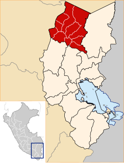
Puno is a department in southeastern Peru. It is bordered by Bolivia on the east, the departments of Madre de Dios on the north, Cusco and Arequipa on the west, Moquegua on the southwest, and Tacna on the south. Its capital is the city of Puno, which is located on Lake Titicaca in the geographical region known as the Altiplano or high sierra.

Carabaya Province is a province of the Puno Region in the southern part of Peru. It is bounded on the north by the Madre de Dios Region, on the east by the Sandia Province, on the south by the provinces of Azángaro, Melgar and Putina and on the west by the Cusco Region. The capital of the province is the city of Macusani.

San Antonio de Putina Province is a province of the Puno Region in Peru.
San José District is one of fifteen districts of the Azángaro Province in Peru.
Cuyocuyo District is one of ten districts of the province Sandia in Peru.
Quiaca District is one of ten districts of the province Sandia in Peru.

Ananea District is one of five districts of the San Antonio de Putina Province in Peru.

Sina District is one of five districts of the San Antonio de Putina Province in the Puno Region of Peru.
Putina District is one of five districts of the San Antonio de Putina Province in Peru.
Pedro Vilca Apaza District is one of five districts of the province San Antonio de Putina in Peru.

Chaupi Orco or Viscachani is a mountain in the Andes on the border of Bolivia and Peru. It has a height of 6,044 metres (19,829 ft). On the Bolivian side it is located in the La Paz Department, Franz Tamayo Province, Pelechuco Municipality, and on the Peruvian side it lies in the Puno Region, Putina Province, Sina District. It lies north of Salluyu.

Ritipata is a 5,350-metre-high (17,552 ft) mountain in the Apolobamba mountain range in the Andes of Peru. It is located in the Puno Region, Putina Province, Ananea District, as well as in the Sandia Province, Quiaca District. Ritipata is situated south-east of the mountain Vilacota, east of the mountain Ananea and north-west of the mountain Chapi, next to it.

Chapi or Ch'api is a 5,400-metre-high (17,717 ft) mountain in the Apolobamba mountain range in the Andes of Peru. It is located in the Puno Region, Putina Province, on the border of the districts Ananea and Sina. Chapi is situated southeast of the mountains Ananea and Ritipata, north-west of Riti Urmasca and north-east of the lake Asnococha.

Riti Urmasca or Ritiurcamasca is a mountain in the Andes of Peru, about 5,200 metres (17,060 ft) high. It is situated in the Puno Region, Putina Province, on the border of the districts Ananea and Sina. Riti Urmasca lies southeast of the mountain Ritipata and southwest of Chaupi Orco at the mountain pass Iscaycruz.

Punta Yavre or Punta Yayre is a mountain in the northeast of the Apolobamba mountain range on the border of Bolivia and Peru. It is about 4,600 metres (15,092 ft) high. On the Bolivian side it is located in the La Paz Department, Franz Tamayo Province, Pelechuco Municipality, and on the Peruvian side it lies in the Puno Region, Putina Province, Sina District. Punta Yavre is situated northwest and northeast of the mountains Chawpi Urqu and Kulli Pata.

Choquechambi is a mountain in the Apolobamba mountain range in Peru, about 5,000 metres (16,404 ft) high. It is situated in the Puno Region, Putina Province, on the border of the Ananea District and the Sina District. Choquechambi lies northwest of Riti Urmasca and southeast of Ritipata, Chapi and Yanauma.
Lake Chullpacocha is a lake in the Andes of Peru. It is located in the Puno Region, Putina Province, Ananea District, south of Ananea.

Puma Wachana is a mountain in Peru, about 5,000 metres (16,404 ft) high. It is located in the Puno Region, Putina Province, in the west of the Ananea District.
Sayt'uqucha or Sayt'u Qucha is a lake in Peru. It is situated in the Puno Region, Sandia Province, Cuyocuyo District.

Yanauma is a 5,009-metre-high (16,434 ft) mountain in the Apolobamba mountain range in the Andes of Peru. It is situated in the Puno Region, Putina Province, on the border of the districts of Ananea and Sina. Yanauma lies northwest of the Riti Urmasca, north of Choquechambi, east of Chapi and southeast of Ritipata.


