Sina District

Last updated
Sina
Location of the province San Antonio de Putina in Puno.svg
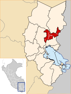
Location of Sina in the San Antonio de Putina Province
Country Flag of Peru.svg  Peru
Region Puno
Province San Antonio de Putina
FoundedMay 2, 1854
Capital Sina
Government
   Mayor Ricardo Flores Hilasaca
Area
  Total
163.43 km2 (63.10 sq mi)
Elevation
3,229 m (10,594 ft)
Population
  Total
1,472
  Density9.0/km2 (23/sq mi)
Time zone UTC-5 (PET)
UBIGEO 211005

Sina District is one of five districts of the San Antonio de Putina Province in the Puno Region of Peru. [1]

Contents

Geography

The Apolobamba mountain range traverses the district. The highest peaks of the district is Chawpi Urqu at 6,044 m (19,829 ft) above sea level which is also the highest elevation of the range. Other mountains are listed below: [2]

History

Sina District was created on May 2, 1854.

Ethnic groups

The people in the district are mainly indigenous citizens of Quechua descent. Quechua is the language which the majority of the population (80.79%) learnt to speak in childhood, 15.54% of the residents started speaking using the Spanish language (2007 Peru Census). [3]

Mayors

Festivities

References

  1. (in Spanish) Instituto Nacional de Estadística e Informática. Banco de Información Distrital Archived 2008-04-23 at the Wayback Machine . Retrieved April 11, 2008.
  2. escale.minedu.gob.pe/ UGEL map Putina Province (Puno Region)
  3. inei.gob.pe Archived 2013-01-27 at the Wayback Machine INEI, Peru, Censos Nacionales 2007, Frequencias: Preguntas de Población: Idioma o lengua con el que aprendió hablar (in Spanish)

14°30′05″S69°34′30″W / 14.5013°S 69.5749°W / -14.5013; -69.5749