
Calacoto or Qala Qutu is the third municipal section of the Pacajes Province in the La Paz Department, Bolivia. Its seat is Calacoto.
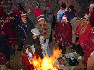
Willkakuti, Machaq Mara, Mara T'aqa, Jach'a Laymi or Pacha Kuti is an Aymara celebration in Bolivia, Chile and in the Southern Peru which commemorates the winter solstice in the Southern Hemisphere.

Kimsa Chata, also spelled Kimsachata, is a 4,735-metre-high (15,535 ft) mountain in the Andes in Bolivia. It is located in the Chilla-Kimsa Chata mountain range south-east of Wiñaymarka Lake, the southern part of Lake Titicaca. It lies in the La Paz Department, Ingavi Province, Tiwanaku Municipality, about 15 km south of the archaeological site of Tiwanaku and the village of the same name. Kimsa Chata is situated between the mountains Nasa Puqi in the north and Chuqi Ch'iwani in the south.

Qala T'uxu or Qala Tuqu is a mountain in the Cordillera Real in the Andes of Bolivia, about 5,076 metres (16,654 ft) high. It is located in the La Paz Department, Los Andes Province, Batallas Municipality, Chachacomani Canton. It is situated south-west of the mountains Wila Lluxi and Warawarani and north-west of the mountain Phaq'u Kiwuta.
Uma Jalanta is a mountain in the Cordillera Real in the Andes of Bolivia, about 5,723 metres (18,776 ft) high. It is located in the La Paz Department, Larecaja Province, Sorata Municipality. It lies south-east of the mountains Janq'u Uma and Janq'u Piti, near the mountain Misk'i T'ant'a.
Wiluyu Janq'u Uma or Wiluyu is a mountain in the Cordillera Real in the Andes of Bolivia, about 5,540 metres (18,176 ft) high. It is located in the La Paz Department, Larecaja Province, Sorata Municipality. It lies northwest of the mountain Yapuchañani, northeast of Misk'i T'ant'a and Uma Jalanta and east of Illampu.
Nasa Puqi is a 4,735-metre-high (15,535 ft) mountain in the Andes in Bolivia. It is located in the Chilla-Kimsa Chata mountain range south-east of Wiñaymarka Lake, the southern part of Lake Titicaca. It lies in the La Paz Department, Ingavi Province, Tiwanaku Municipality. Nasa Puqi is situated north of the mountains Chuqi Ch'iwani and Kimsa Chata.
Chuqi Ch'iwani is a 4,695-metre-high (15,404 ft) mountain in the Chilla-Kimsa Chata mountain range in the Andes of Bolivia. It lies south-east of Wiñaymarka Lake, the southern part of Lake Titicaca. It is located in the La Paz Department, Ingavi Province, at the border of the Jesús de Machaca Municipality and the Tiwanaku Municipality. Chuqi Ch'iwani is situated south of the mountains Nasa Puqi and Kimsa Chata.
Chuqi Q'awa is a 4,570-metre-high (14,993 ft) mountain in the Chilla-Kimsa Chata mountain range in the Andes of Bolivia. It lies in the La Paz Department, Ingavi Province, in the north of the Jesús de Machaca Municipality, near the border with the Tiwanaku Municipality. Chuqi Q'awa is situated south of the river Chuñuni Jawira (Chununi Jahuira).
Qala Waxrani is a 4,316-metre-high (14,160 ft) mountain in the Chilla-Kimsa Chata mountain range in the Andes of Bolivia. It is situated in the La Paz Department, Ingavi Province, Guaqui Municipality, south-east of Guaqui.
Qala P'axrani is a 4,262-metre-high (13,983 ft) mountain in the Chilla-Kimsa Chata mountain range in the Andes of Bolivia. It lies in the La Paz Department, Los Andes Province, Laja Municipality. Qala P'axrani is situated south-west of Pukara (Pucara), north-west of the mountain Kunkani. The river Ch'amaka Jawira originates near the mountain. It flows to the north as a left tributary of Wakira River.

Layqa Qullu is a 6,166-metre-high (20,230 ft) peak in the Cordillera Real in the Andes of Bolivia. It is one of the highest peaks in the Illimani massif. It is situated in the La Paz Department, Murillo Province, Palca Municipality, and in the Sud Yungas Province, Irupana Municipality. Layqa Qullu lies south-east of the highest point of the massif, north-west of Link'u Link'u and Silla Pata.
Uyu K'uchu is a mountain in the Cordillera Real in the Andes of Bolivia, about 4,800 metres (15,748 ft) high. It is situated in the La Paz Department, Murillo Province, La Paz Municipality. Uyu K'uchu lies south of the mountain Sankayuni and north-east of the mountain Kunturiri.
Qala Phusa is a 4,884-metre-high (16,024 ft) mountain in the Andes of Bolivia. It is situated in the La Paz Department, Larecaja Province, Sorata Municipality. Qala Phusa lies north of the Janq'u Uma-Illampu massif of the Cordillera Real, northwest of the mountain Wila Quta and southeast of Llawi Imaña.
Salluyu is a mountain in the Apolobamba mountain range at the border of Bolivia and Peru, about 5,650 metres (18,537 ft) high. It is situated in the La Paz Department, Franz Tamayo Province, Pelechuco Municipality, near 14°40′03″S69°13′57″W. Salluyu lies between the peaks of Chawpi Urqu in the north and Palumani in the south.
Cunuyo is a mountain in the north of the Apolobamba mountain range on the border of Bolivia and Peru. It is about 5,100 metres (16,732 ft) high. On the Bolivian side it is located in the La Paz Department, Franz Tamayo Province, Pelechuco Municipality, and on the Peruvian side it lies in the Puno Region, Putina Province, Sina District. Cunuyo is situated southwest of the mountain Locopauchenta and east of Losojocha.
Wila Qullu is a mountain in the Chilla-Kimsa Chata mountain range in the Andes of Bolivia which reaches a height of approximately 4,400 m (14,400 ft). It is located in the La Paz Department, Ingavi Province, on the border of the municipalities of Jesús de Machaca and Tiwanaku. Wila Qullu lies north of Chuqi Q'awa.
The Ch'alla Jawira is a river in the La Paz Department in Bolivia. It is a left tributary of the Tiwanaku River which empties into Wiñaymarka Lake, the southern part of Lake Titicaca.
Qiwñuyu is a 4,428-metre-high (14,528 ft) mountain in the Andes of Bolivia. It is situated in the La Paz Department, José Manuel Pando Province, Catacora Municipality. The Junt'uni Jawira originates at the mountain. It flows to the southeast.


