Instrument flight rules (IFR) is one of two sets of regulations governing all aspects of civil aviation aircraft operations; the other is visual flight rules (VFR).
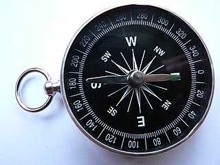
A compass is an instrument used for navigation and orientation that shows direction relative to the geographic cardinal directions. Usually, a diagram called a compass rose shows the directions north, south, east, and west on the compass face as abbreviated initials. When the compass is used, the rose can be aligned with the corresponding geographic directions; for example, the "N" mark on the rose points northward. Compasses often display markings for angles in degrees in addition to the rose. North corresponds to 0°, and the angles increase clockwise, so east is 90° degrees, south is 180°, and west is 270°. These numbers allow the compass to show magnetic North azimuths or true North azimuths or bearings, which are commonly stated in this notation. If magnetic declination between the magnetic North and true North at latitude angle and longitude angle is known, then direction of magnetic North also gives direction of true North.

Flight instruments are the instruments in the cockpit of an aircraft that provide the pilot with information about the flight situation of that aircraft, such as altitude, airspeed and direction. They improve safety by allowing the pilot to fly the aircraft in level flight, and make turns, without a reference outside the aircraft such as the horizon. Visual flight rules (VFR) require an airspeed indicator, an altimeter, and a compass or other suitable magnetic direction indicator. Instrument flight rules (IFR) additionally require a gyroscopic pitch-bank, direction and rate of turn indicator, plus a slip-skid indicator, adjustable altimeter, and a clock. Flight into Instrument meteorological conditions (IMC) require radio navigation instruments for precise takeoffs and landings.

Magnetic declination, or magnetic variation, is the angle on the horizontal plane between magnetic north and true north. This angle varies depending on position on the Earth's surface and changes over time.

The basic principles of air navigation are identical to general navigation, which includes the process of planning, recording, and controlling the movement of a craft from one place to another.

A non-directional (radio) beacon (NDB) is a radio transmitter at a known location, used as an aviation or marine navigational aid. As the name implies, the signal transmitted does not include inherent directional information, in contrast to other navigational aids such as low frequency radio range, VHF omnidirectional range (VOR) and TACAN. NDB signals follow the curvature of the Earth, so they can be received at much greater distances at lower altitudes, a major advantage over VOR. However, NDB signals are also affected more by atmospheric conditions, mountainous terrain, coastal refraction and electrical storms, particularly at long range.
Piloting or pilotage is navigating, using fixed points of reference on the sea or on land, usually with reference to a nautical chart or aeronautical chart to obtain a fix of the position of the vessel or aircraft with respect to a desired course or location. Horizontal fixes of position from known reference points may be obtained by sight or by radar. Vertical position may be obtained by depth sounder to determine depth of the water body below a vessel or by altimeter to determine an aircraft's altitude, from which its distance above the ground can be deduced. Piloting a vessel is usually practiced close to shore or on inland waterways. Pilotage of an aircraft is practiced under visual meteorological conditions for flight.

Flight plans are documents filed by a pilot or flight dispatcher with the local Civil Aviation Authority prior to departure which indicate the plane's planned route or flight path. Flight plan format is specified in ICAO Doc 4444. They generally include basic information such as departure and arrival points, estimated time en route, alternate airports in case of bad weather, type of flight, the pilot's information, number of people on board and information about the aircraft itself. In most countries, flight plans are required for flights under IFR, but may be optional for flying VFR unless crossing international borders. Flight plans are highly recommended, especially when flying over inhospitable areas, such as water, as they provide a way of alerting rescuers if the flight is overdue. In the United States and Canada, when an aircraft is crossing the Air Defense Identification Zone (ADIZ), either an IFR or a special type of VFR flight plan called a DVFR flight plan must be filed. For IFR flights, flight plans are used by air traffic control to initiate tracking and routing services. For VFR flights, their only purpose is to provide needed information should search and rescue operations be required, or for use by air traffic control when flying in a "Special Flight Rules Area".

Emergency evacuation is the urgent immediate egress or escape of people away from an area that contains an imminent threat, an ongoing threat or a hazard to lives or property.
A second mate or second officer (2/O) is a licensed member of the deck department of a merchant ship holding a Second Mates Certificate of Competency, which is issued by the administration. The second mate is the third in command and a watchkeeping officer, customarily the ship's navigator. Other duties vary, but the second mate is often the medical officer and in charge of maintaining distress signaling equipment. On oil tankers, the second mate usually assists the chief mate with the Cargo operations.

A helmsman or helm is a person who steers a ship, sailboat, submarine, other type of maritime vessel, or spacecraft. The rank and seniority of the helmsman may vary: on small vessels such as fishing vessels and yachts, the functions of the helmsman are combined with that of the skipper; on larger vessels, there is a separate officer of the watch who is responsible for the safe navigation of the ship and gives orders to the helmsman, who physically steers the ship in accordance with those orders.
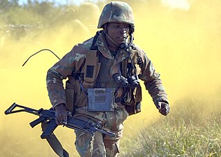
The five paragraph order or five paragraph field order is a style of organizing information about a military situation for a unit in the field. It is an element of United States Army, United States Marine Corps and United States Navy Seabees of small unit tactics, and similar order styles are used by military groups around the world. An order specifies the instruction to a unit in a structured format that makes it easy to find each specific requirement. The five paragraphs can be remembered with the acronym SMEAC: "S" Situation, "M" Mission, "E" Execution, "A" Administration/Logistics, "C" Command/Signal.

Diver navigation, termed "underwater navigation" by scuba divers, is a set of techniques—including observing natural features, the use of a compass, and surface observations—that divers use to navigate underwater. Free-divers do not spend enough time underwater for navigation to be important, and surface supplied divers are limited in the distance they can travel by the length of their umbilicals and are usually directed from the surface control point. On those occasions when they need to navigate they can use the same methods used by scuba divers.
Global Navigation Satellite System (GNSS) receivers, using the GPS, GLONASS, Galileo or BeiDou system, are used in many applications. The first systems were developed in the 20th century, mainly to help military personnel find their way, but location awareness soon found many civilian applications.

TWA Flight 3 was a twin-engined Douglas DC-3-382 propliner, registration NC1946, operated by Transcontinental and Western Air as a scheduled domestic passenger flight from New York City, to Burbank, California, via Indianapolis, Indiana, St. Louis, Missouri, Albuquerque, New Mexico, and Las Vegas, Nevada. On January 16, 1942, at 19:20 PST, 15 minutes after takeoff from Las Vegas Airport bound for Burbank, the aircraft slammed into a sheer cliff on Potosi Mountain, 32 miles (51 km) southwest of the airport, at an elevation of 7,770 ft (2,370 m) above sea level, and was destroyed. All 22 people on board — including movie star Carole Lombard, her mother, and three crew members — died in the crash. The Civil Aeronautics Board (CAB) investigated the accident and determined it was caused by a navigation error by the captain.
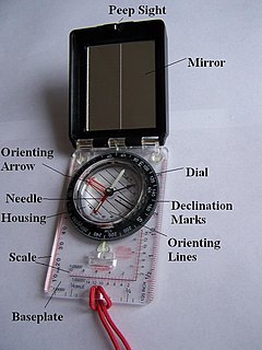
A hand compass is a compact magnetic compass capable of one-hand use and fitted with a sighting device to record a precise bearing or azimuth to a given target or to determine a location. Hand or sighting compasses include instruments with simple notch-and-post alignment ("gunsights"), prismatic sights, direct or lensatic sights, and mirror/vee (reflected-image) sights. With the additional precision offered by the sighting arrangement, and depending upon construction, sighting compasses provide increased accuracy when measuring precise bearings to an objective.
Resection is a method for determining an unknown position measuring angles with respect to known positions. Measurements can be made with a compass and topographic map, Theodolite or with a total station using known points of a Geodetic network or landmarks of a map.

The Military Load Classification (MLC) is a system of standards used by NATO to classify the safe amount of load a surface can withstand. Load-carrying capacity is shown in whole numbers for vehicles, bridges, roads, and routes. Vehicles are classified by weight, type, and effect on routes. Bridges, roads, and routes are classified by physical characteristics, type and flow of traffic, effects of weather, and other special conditions.
The compass was invented more than 2,000 years ago. The first compasses were made of lodestone, a naturally magnetized stone of iron, in Han dynasty China between 300 and 200 BC. The compass was later used for navigation by the Song Dynasty. Later compasses were made of iron needles, magnetized by striking them with a lodestone. Dry compasses begin appearing around 1300 in Medieval Europe and the Medieval Islamic world. This was replaced in the early 20th century by the liquid-filled magnetic compass.