
Cidade Velha is a city in the southern part of the island of Santiago, Cape Verde. Founded in 1462, it is the oldest settlement in Cape Verde and its former capital. Once called Ribeira Grande, its name was changed to Cidade Velha in the late 18th century. It is the seat of the Ribeira Grande de Santiago municipality.

Estádio Municipal Adérito Sena is a multi-use stadium in Mindelo, Cape Verde. It is currently used mostly for football matches and is the home stadium of FC Derby as well as CS Mindelense, Académica, GD Amarantes and Batuque FC and the lesser club of Corinthians São Vicente. The stadium holds 5,000 people and area is 105x68 m and its ground is artificial grass. The stadium is owned by the municipality of São Vicente and is operated by the São Vicente Regional Football Association (ARFSV). It is a certified stadium by FIFA for international competition as well as friendly matches

The Radiotelevisão Caboverdiana is Cape Verde's first radio and television station broadcasting local programs from Cape Verde, Portugal and Brazil as well as the rest of the world especially France. It is a publicly owned company and enterprise and is located in the Capeverdean capital city of Praia, in the southern part in the middle of Achada Santo António RTC also has a few buildings, it also has offices in São Vicente, Sal, São Filipe on Fogo Island and Assomada in Santa Catarina. The building size is very small, only like local affiliates in North America as well as Latin America, Australia and Europe. The radio building is in the south on Rua 13 de Janeiro and the television station is in the north. Its current president is José Emanuel Tavares Moreira/
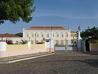
The Palácio da Presidência da República is a public building in the city centre of Praia, the capital of Cape Verde. It is situated on Rua Serpa Pinto, at the south end of Plateau, the historic district of Praia. It was constructed around 1894 in neoclassical style as a residence of the Portuguese governor of Cape Verde. After Cape Verde gained independence in 1975, it became the presidential palace.

Avenida Marginal is an important street in Mindelo, São Vicente island, Cape Verde. It runs along the coast of the Porto Grande Bay, connecting the city centre with the northwestern outskirts (Matiota). Its southern end is the intersection with Rua Libertadores de África and Rua da Praia, that continues south along the coast. Avenida Marginal runs along the port of Mindelo, below Fortim d'El-Rei and along Praia da Laginha in Matiota.

Rua Libertadores de África is one of the main streets in the city centre of Mindelo, Cape Verde It was formerly called Rua Lisboa. It runs from the seaside Avenida Marginal to the Palácio do Povo.
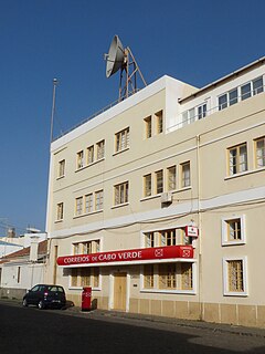
Correios de Cabo Verde is the company responsible for postal service in Cape Verde. The headquarters of the company are in the city centre of Praia, at Rua Cesário Lacerda, nº 2.

Cape Verde was a colony of the Portuguese Empire from the initial settlement of the Cape Verde Islands in 1462 until the independence of Cape Verde in 1975.

The Arquivo Nacional de Cabo Verde is the national archive of Cape Verde. It is located in the capital city of Praia, on Avenida Combatentes da Liberdade da Patria, in the subdivision of Chã de Areia. It is housed in the former customs building, that was built in 1878.
Museu Etnográfico da Praia is an ethnographic museum in the Cape Verdean capital of Praia on the island of Santiago. It is located at 45 Rua 5 de Julho, in the historic part of the city, the Plateau. The museum was opened in November 1997 and is located in a 19th century building. The museum contains a selection of objects that represent the traditional uses and customs of the Cape Verdean people.

Praça Alexandre Albuquerque is the main square of the capital city of Praia, Cape Verde. It is located in the southwestern part of the Plateau, the historical city centre of Praia. Formerly known as Praça do Pelourinho, it received its current name in 1876 in honour of the Portuguese colonial governor Caetano Alexandre de Almeida e Albuquerque. It is lined with several historical public buildings and townhouses, many of which date from the 19th century. The square is surrounded by Rua Patrice Lumumba, Rua Serpa Pinto and Avenida Amílcar Cabral.

GimnodesportivoVavá Duarte is a multi-purpose stadium in Praia, Cape Verde south of the city center's plateau in the subdivision of Gamboa just south of Várzea and is located on Avenida de Cuba, a road connecting the south of the city and the north and the southwest of the island. It is currently used for basketball, volleyball and futsal matches. The arena are operated by the Santiago South Regional Basketball Association for basketball, the Santiago South Regional Volleyball Association for volleyball and probably the Santiago Regional Futsal Association for futsal. These associations are also headquartered in the arena and around it.

Avenida Andrade Corvo is an avenue in the Plateau of Praia, in the city centre of Praia, Santiago island, Cape Verde. It was named in honour of 19th century Portuguese politician João de Andrade Corvo. It runs south to north in the eastern part of the Plateau, parallel to Rua Serpa Pinto. Its northern end is formed by Praça Luís de Camões.

There is also Rua Serpa Pinto in the neighbourhood of Mártires in Lisbon, Portugal

Avenida Amílcar Cabral is an avenue in the Plateau, the historic centre of Praia, Santiago island, Cape Verde. It is the neighborhood's longest street and the main artery of the city centre. Formerly named Rua Sá da Bandeira after 19th century Portuguese politician Sá da Bandeira, it was renamed after Cape Verdean independence in honour of Amílcar Cabral, leader of the independence movement of Cape Verde and Guinea-Bissau. It runs south to north in the western part of the Plateau, parallel to Rua 5 de Julho, Rua Serpa Pinto and Avenida Andrade Corvo. It forms the west side of Praça Alexandre Albuquerque.

Quintal da Música, abbreviation: 5tal da Música is a music pub located in the downtown area of Praia, the Plateau and is located at 70A Avenida Amílcar Cabral in the northern part of the center, across Rua António Pusich and south of Rua António Macedo. It is one of the most famous and most used pubs and music pubs in Cape Verde.

Avenida Cidade de Lisboa is an avenue west of the center of Praia, Santiago island, Cape Verde. It runs along the neighbourhoods of Várzea, Achadinha and Chã de Areia. It is one of the major arterial roads of the city. The street is named for Praia's town twinning with the city of Lisbon, Portugal. It runs south to north, west of the Plateau. The annual carnival parade takes place on Avenida Cidade de Lisboa.
Praça Luís de Camões is the second main square of the capital city of Praia, Cape Verde. It is located between Rua Serpa Pinto and Avenida Andrade Corvo in the eastern part of the Plateau, the historical city centre of Praia. The square is named after the 16th century Portuguese writer Luís de Camões.

Liceu Domingos Ramos is a public secondary school in the northern part of the city centre (Plateau) of Praia, Cape Verde. As of 2015, it has 2,300 students, 63 classes and 110 teachers. It was established as Liceu Adriano Moreira in 1960. In 1975, at the independence of Cape Verde, it was renamed Liceu Domingos Ramos.


