There is also Rua Serpa Pinto in the neighbourhood of Mártires in Lisbon, Portugal

Lisbon is the capital and the largest city of Portugal, with an estimated population of 505,526 within its administrative limits in an area of 100.05 km2. Its urban area extends beyond the city's administrative limits with a population of around 2.8 million people, being the 11th-most populous urban area in the European Union. About 3 million people live in the Lisbon Metropolitan Area. It is mainland Europe's westernmost capital city and the only one along the Atlantic coast. Lisbon lies in the western Iberian Peninsula on the Atlantic Ocean and the River Tagus. The westernmost areas of its metro area form the westernmost point of Continental Europe, which is known as Cabo da Roca, located in the Sintra Mountains.
 | |
| Former name(s) | Rua do Lencastre |
|---|---|
| Namesake | Alexandre de Serpa Pinto |
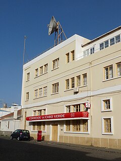
| Location | Praia, Cape Verde |
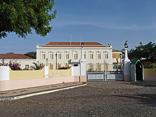
| South end | Presidential Palace |
| North end | Praça Domingos Ramos |
Rua Serpa Pinto (formerly Rua do Lencastre) is a street in the Plateau, the historic centre of Praia, Santiago island, Cape Verde. [1] It is one of the main arteries of the city centre. Formerly named Rua do Lencastre after early 19th century Portuguese governor António Lencastre, it was renamed in honour of Alexandre de Serpa Pinto, Portuguese colonial administrator. It runs south to north in the central part of the Plateau, parallel to Rua 5 de Julho and Avenida Andrade Corvo. It forms the east side of Praça Alexandre Albuquerque and the west side of Praça Luís de Camões.
Plateau is the historic centre of the capital city of Praia in the island of Santiago, Cape Verde. It gets its name because it is situated on a plateau overlooking the port of Praia. Its average elevation is 37 meters above sea level. The population of Plateau was 1,019 at the 2010 census. Many public buildings are situated in Plateau, notably the Presidential Palace, the cathedral, the city hall and the Ethnographic Museum.

Praia, is the capital and largest city of Cape Verde, an island nation in the Atlantic Ocean west of Senegal. It lies on the southern coast of Santiago island in the Sotavento Islands group. It is the island's ferry port and is home to one of the nation's four international airports. The city centre is known as Plateau due to its location on a small plateau.

Santiago is the largest island of Cape Verde, its most important agricultural centre and home to half the nation’s population. Part of the Sotavento Islands, it lies between the islands of Maio and Fogo. It was the first of the islands to be settled: the town of Ribeira Grande was founded in 1462. Santiago is home to the nation's capital city of Praia.
Notable buildings along the street: [1]
- Presidential Palace (Palácio Presidencial)
- Pro-Cathedral of Our Lady of Grace, at Praça Alexandre Albuquerque
- Escola Grande, at Praça Luís de Camões
- the Nazarene church, built in 1947
- Liceu Domingos Ramos, at Praça Domingos Ramos
The Palácio da Presidência da República is a public building in the city centre of Praia, the capital of Cape Verde. It is situated on Rua Serpa Pinto, at the south end of Plateau, the historic district of Praia. It was constructed around 1894 in neoclassical style as a residence of the Portuguese governor of Cape Verde. After Cape Verde gained independence in 1975, it became the presidential palace.

The Pro-Cathedral of Our Lady of Grace is a catholic church on the east side of Praça Alexandre Albuquerque, in the city centre of Praia, on the island of Santiago, Cape Verde. The church was built between 1894 and 1902. It is the seat of the Roman Catholic Diocese of Santiago de Cabo Verde, which was created in 1533. It is under the pastoral responsibility of Arlindo Gomes Furtado Cardinal.

Liceu Domingos Ramos is a public secondary school in the northern part of the city centre (Plateau) of Praia, Cape Verde. As of 2015, it has 2,300 students, 63 classes and 110 teachers. It was established as Liceu Adriano Moreira in 1960. In 1975, at the independence of Cape Verde, it was renamed Liceu Domingos Ramos.