
The history of Greenland is a history of life under extreme Arctic conditions: currently, an ice sheet covers about eighty percent of the island, restricting human activity largely to the coasts.
The Thule or proto-Inuit were the ancestors of all modern Inuit. They developed in coastal Alaska by the year 1000 and expanded eastward across northern Canada, reaching Greenland by the 13th century. In the process, they replaced people of the earlier Dorset culture that had previously inhabited the region. The appellation "Thule" originates from the location of Thule in northwest Greenland, facing Canada, where the archaeological remains of the people were first found at Comer's Midden. The links between the Thule and the Inuit are biological, cultural, and linguistic.

The Norse exploration of North America began in the late 10th century, when Norsemen explored areas of the North Atlantic colonizing Greenland and creating a short term settlement near the northern tip of Newfoundland. This is known now as L'Anse aux Meadows where the remains of buildings were found in 1960 dating to approximately 1,000 years ago. This discovery helped reignite archaeological exploration for the Norse in the North Atlantic. This single settlement, located on the island of Newfoundland and not on the North American mainland, was abruptly abandoned.
Skræling is the name the Norse Greenlanders used for the peoples they encountered in North America. In surviving sources, it is first applied to the Thule people, the proto-Inuit group with whom the Norse coexisted in Greenland after about the 13th century. In the sagas, it is also used for the peoples of the region known as Vinland whom the Norse encountered and fought during their expeditions there in the early 11th century.

The Dorset was a Paleo-Eskimo culture, lasting from 500 BCE to between 1000 CE and 1500 CE, that followed the Pre-Dorset and preceded the Thule people (proto-Inuit) in the North American Arctic. The culture and people are named after Cape Dorset in Nunavut, Canada, where the first evidence of its existence was found. The culture has been defined as having four phases due to the distinct differences in the technologies relating to hunting and tool making. Artifacts include distinctive triangular end-blades, oil lamps made of soapstone, and burins.

Nares Strait is a waterway between Ellesmere Island and Greenland that connects the northern part of Baffin Bay in the Atlantic Ocean with the Lincoln Sea in the Arctic Ocean. From south to north, the strait includes Smith Sound, Kane Basin, Kennedy Channel, Hall Basin and Robeson Channel. Nares Strait has a nearly permanent current from the north, powered by the Beaufort Gyre, making it harder to traverse for ships coming from the south.
Skraeling Island lies off the east coast of Ellesmere Island in the Canadian territory of Nunavut, at the mouth of Alexandra Fiord. Buchanan Bay lies to its north-east.
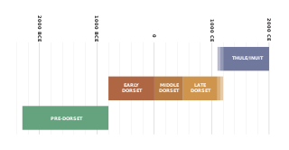
The history of Nunavut covers the period from the arrival of the Paleo-Eskimo thousands of years ago to present day. Prior to the colonization of the continent by Europeans, the lands encompassing present-day Nunavut were inhabited by several historical cultural groups, including the Pre-Dorset, the Dorsets, the Thule and their descendants, the Inuit.
James A. Tuck, was an American-born archaeologist whose work as a faculty member of the Memorial University of Newfoundland was focused on the early history of Newfoundland and Labrador.
Based on archeological finds, Brooman Point Village is an abandoned village in Qikiqtaaluk Region, Nunavut, Canada. It is located in the central High Arctic near Brooman Point of the Gregory Peninsula, part of the eastern coast of Bathurst Island. Brooman was both a Late Dorset culture Paleo-Eskimo village as well as an Early Thule culture village. Both the artifacts and the architecture, specifically longhouses, are considered important historical remains of the two cultures. The site shows traces of Palaeo-Eskimo occupations between about 2000 BC and 1 AD, but the major prehistoric settlement occurred from about 900 to 1200 AD.
Comer's Midden was a 1916 archaeological excavation site near Thule, north of Mt. Dundas in North Star Bay in northern Greenland. It is the find after which the Thule culture was named. The site was first excavated in 1916 by whaling Captain George Comer, ice master of the Crocker Land Expedition's relief team, and of members of Knud Rasmussen's Second Danish Thule Expedition who were in the area charting the North Greenland coast.

Therkel Mathiassen was an archaeologist, anthropologist, cartographer, and ethnographer notable for his scientific study of the Arctic.

Greenlanders are people identified with Greenland or the indigenous people, the Greenlandic Inuit. This connection may be residential, legal, historical, or cultural. For most Greenlanders, many of these connections exist and are collectively the source of their being Greenlandic. However, the term can in different contexts be delimited more precisely in different ways: as the inhabitants of Greenland, as nationals of Greenland or more broadly as persons who feel a cultural affiliation in a broad sense to Greenland. More controversial is a more recent use of the word in the sense persons of Greenlandic origin, i.e. persons whose parents were born in Greenland.
Dr. Erik Holtved was a Danish artist, archaeologist, linguist, and ethnologist. He was the first university-trained ethnologist to study the Inughuit, the northernmost Greenlandic Inuit.
Inglefield Land is an unglaciated area along the northwestern coast of Greenland. It was named after English explorer Edward Augustus Inglefield.

Herjolfsnes was a Norse settlement in Greenland, 50 km northwest of Cape Farewell. It was established by Herjolf Bardsson in the late 10th century and is believed to have lasted some 500 years. The fate of its inhabitants, along with all the other Norse Greenlanders, is unknown. The site is known today for having yielded remarkably well-preserved medieval garments, excavated by Danish archaeologist Poul Nörlund in 1921. Its name roughly translates as Herjolf's Point or Cape.

Skjoldungen is a large uninhabited island in the King Frederick VI Coast, southeastern Greenland. Administratively it is part of the Sermersooq municipality. The weather of the island is characterized by tundra climate.

King Frederick VI Coast is a major geographic division of Greenland. It comprises the coastal area of Southeastern Greenland in Sermersooq and Kujalleq municipalities fronting the Irminger Sea of the North Atlantic Ocean. It is bordered by King Christian IX Land on the north and the Greenland Ice Sheet to the west.

Vatnahverfi was a district in the Norse Greenlanders’ Eastern Settlement (Eystribyggð) and is generally regarded by archaeologists and historians as having the best pastoral land in the colony. The Norse settled Vatnahverfi in the late 10th century and farmed there for nearly 500 years before mysteriously disappearing from the district and the entirety of Greenland, likely at some point in the latter 15th century. Its name is roughly translated as “Lake District."

Kujataa is a sub-arctic farming landscape in the southern region of Greenland. It is the first known example of agriculture in the Arctic, and the oldest evidence of the Old Norse culture spreading outside Europe. The unique juxtaposition of farming and hunting for marine mammals that occurred in the region from the 10th through 15th centuries and from the 18th century to today headlined the region's inscription on the UNESCO World Heritage List in 2017.

